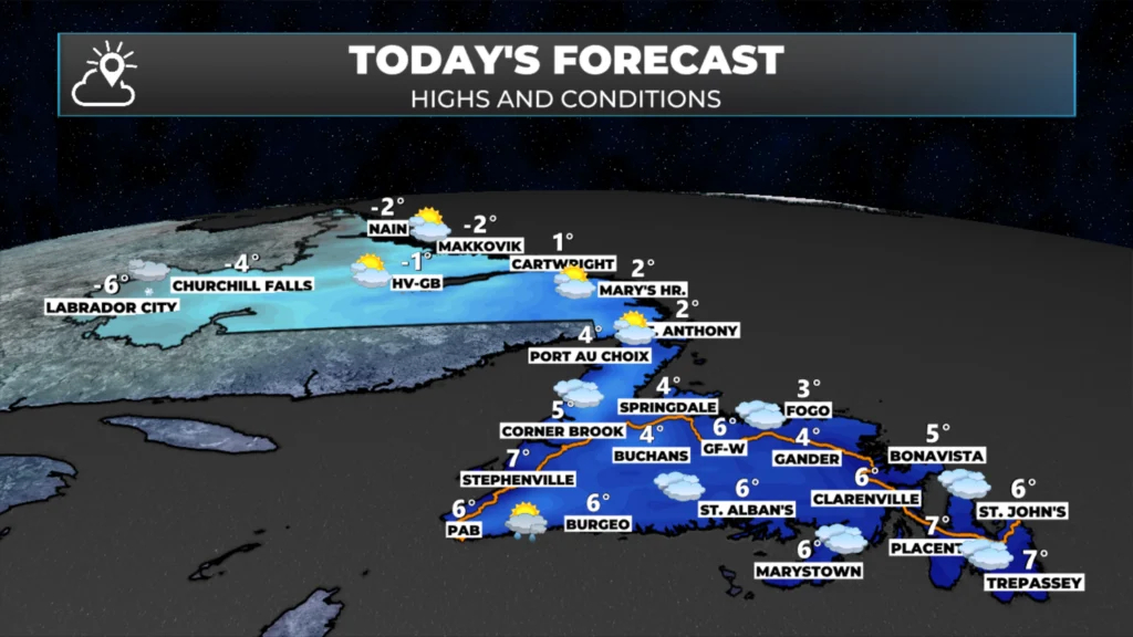
Today will be a good day to take care of any last-minute preparations before this next weather maker moves in. A developing area of low pressure located over eastern Long Island this morning will send rain into Newfoundland and snow into Labrador by this evening.
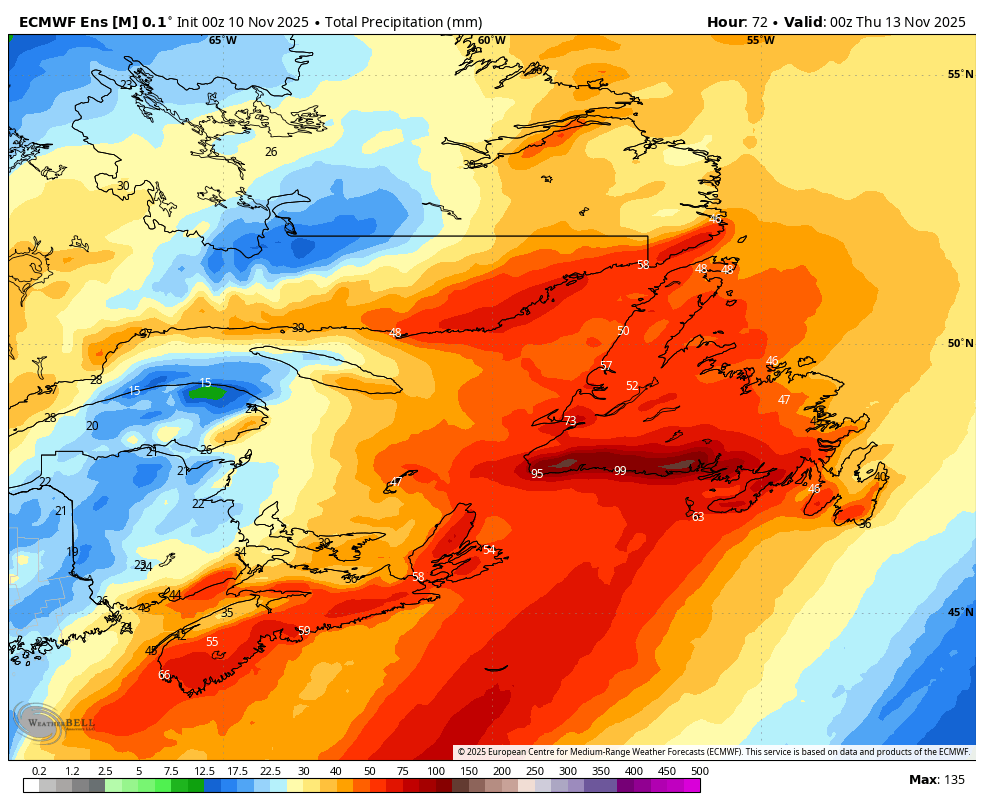
The area of low pressure that will send rain and snow into the region is currently located to the east of New York City. As this low moves north, it’s going to deepen and tap into a considerable amount of moisture. On top of that, there is a tremendous differential in temperature between the west and east sides of this low. The cold air this morning is plunging south and will eventually reach Florida. This is the recipe for a prolonged, high-impact rain event that has the potential to deliver over 100 mm of rain to southern areas of the Island over the next 48 hours or more.
Visit MakeTheCall.ca to learn more about what the law firm can do for you!
The map below shows the current temperature setup stremlines at 5,000 feet (850 mb for you weather nerds) above your head. This gives you a great view of our developing system and how the atmosphere is oriented as this is heading our way.
This system will send rain onto the Island by this afternoon, while Labrador will see snow moving in. As this is a fairly mature low, tapping into various air masses and cutting west of the Big Land, most of Labrador will see a transition to rain tonight or early Tuesday. The rain will continue through Tuesday from this low. A secondary low will develop over the Gulf on Tuesday afternoon, which will then keep the rain going through Tuesday night and into Wednesday on the Island. In Labrador, this second low will tap into some cold air, changing the rain back to snow for areas just inland from the coast, possibly including the Goose Bay area. Rain may also change to snow on Wednesday over parts of western Newfoundland. The animation below shows this well.
THE WIND
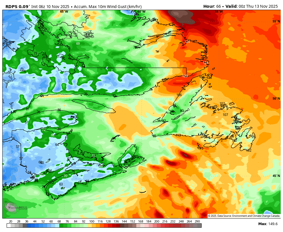
RDPS Model’s Peak Wind Gust Speeds Between Today and Wednesday Evening. Note the peaks will occur at different times.
This system will also produce wind. Wind speeds will peak in the Wreckhouse area from later today through Tuesday morning. Gusts are forecast to reach as high as 130 km/h. The West Coast will experience high wind speeds beginning tonight and continuing into Wednesday. The highest speeds will occur along the Gulf in areas prone to enhanced east and southeast flow. Gusts will be as high as 80 km/h, except along parts of the coast, where peak speeds of 120 km/h are possible.
Across the remainder of the Island, there will be some high wind speeds on Tuesday (gusts up to 80 km/h). There will be another round of wind on Tuesday night and Wednesday. This second peak will produce the higher gusts, with many areas seeing peaks near 100 km/h, both inland and along the coast.
Parts of southeast Labrador will also see a period of high winds late Tuesday and Wednesday with the second low mentioned earlier. Gusts along parts of the coast may exceed 120 km/h.
The Rain and Snow
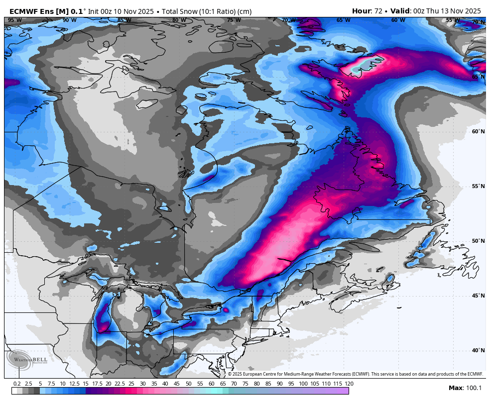
Heavy rain is expected from later today through parts of Wednesday on the Island. Below is the rainfall forecast for this period. Following that is the snowfall forecast. In Labrador, there will be two snow events: one today and tonight, and another on Wednesday. Snow in the east will mainly fall on Wednesday. Some snow may also occur on higher ground in western Newfoundland Wednesday as colder air returns.
Total precipitation forecast between today (November 10, 2025) and Wednesday (November 12, 2025).
Total snowfall forecast from today (November 10, 2025) through Wednesday (November 12, 2025),
My next update will be later today or this evening. Have a great Monday!
⚠ Storm ModeGet warnings pushed to your phone the moment they’re issued.Get the app
By using this website, you agree to our use of cookies. We use cookies to provide you with a great experience and to help our website run effectively. Privacy Policy



Good morning Eddie, thanks for weather update.
Thanks Eddie for the update, have a great day.
I have a flight coming in late Tuesday night at 1:01am… what are the chances I am getting in? When will the winds subside?
Thanks Eddie for keeping us updated.have a great day
Thank you Eddie. Appreciate all the information
It could be worse, right wink wink 😉
Thanks Eddie!