
Monday Morning Weather Brief — August 25, 2025
Good Monday morning!
Here is the latest on the wildfires from Fisheries, Forestry, and ,Agriculture Newfoundland and Labrador:
The Kingston Fire
Ground crews had another strong day Sunday, with NL crews joined by 20 from Ontario, 42 from British Columbia, and three Canadian Armed Forces platoons.
CAF wrapped up their final day of support yesterday — government extended thanks for their hard work.
Conditions (sun + wind) provided a good test of fire behaviour; smoke expected again Sunday night into Monday.
Air + ground crews remain active; water bombers were ready but not needed.
Fire activity and behaviour continue to trend down, but it is still classified as Out of Control at ~10,095 hectares.
Residents may continue to see smoke and an orange glow at night from hot spots.
The Paddy’s Pond Fire
Estimated at 318 hectares, now classified Under Control.
Two NL ground crew remain on site to monitor for changes.
The Martin Lake Fire
Size holds at ~1,633 hectares, now also classified Under Control.
NL ground crews continue to work hot spots with helicopter support.
Part of Miguel Lake resource road reopened, but cabin access beyond Miguel Lake, Martin Lake, and Rushy Pond remains closed; local traffic only.
MONDAY’S OUTLOOK
We are starting the new work week with temperatures in the mid-teens across much of the Island and a significant portion of southern and western Labrador. The majority of coastal Labrador is beginning the day with readings in the single digits. Weather-wise, it’s very quiet across the Island.
This morning’s update is brought to you by Roebothan, McKay, and Marshall.

Visit MakeTheCall.ca to find out what the law firm can do for you!
There may be some foggy spots along the south-facing shores, while scattered showers roam through the Big Land. It’s also breezy for much of the Island with winds from the west southwest at 20 to 30 km/h, gusting as high as 50 km/h.
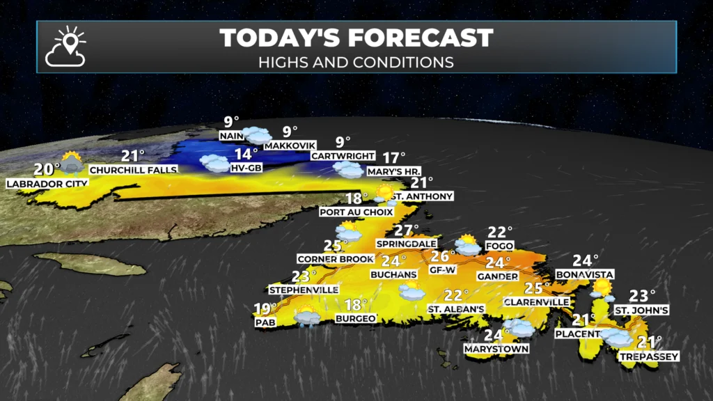
The day is expected to be a quiet one for the Island, with generally a mix of sun and cloud. There may be some late-day showers along and near the south and southwest coast west of the Connaigre Peninsula. Meanwhile, rain will push into Labrador from south to north this afternoon. Reaching the TLH by evening. There may be some thunderstorms around Labrador West this evening as well.
The rain moving through Labrador West today and tonight is in conjunction with an area of low pressure. As the low spins through Labrador tonight and Tuesday, it will bring a fair amount of rain with it. The rain that arrives tonight is expected to persist through Tuesday and Tuesday night before ending on Wednesday morning.
At the same time, another area of low pressure is expected to move from near Cape Cod today toward the Island portion of the Province overnight and on Tuesday, as it is absorbed by the larger system over Labrador. This pattern is going to bring rain to most of the Island on Tuesday, with significant rainfall possible over southern and eastern areas. The rain on the Island will be heaviest in the south and southeast from early Tuesday morning through the afternoon. The rain will ease from south to north on Tuesday night.
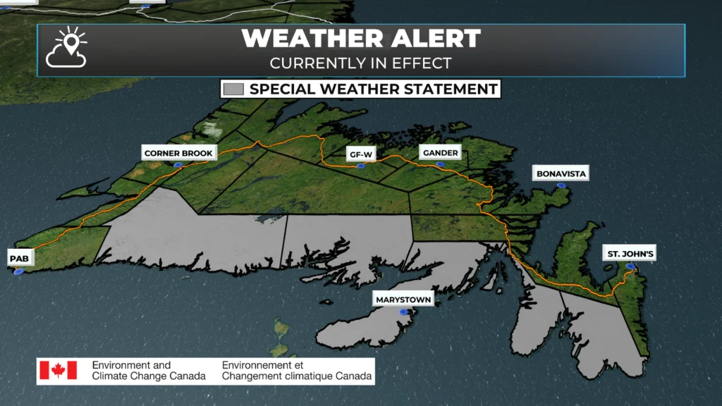
Special Weather Statement issued by ECCC NL due to threat of heavy rainfall over southern Newfoundland late Monday night and Tuesday.
Computer guidance suggests that areas along the southerly-facing shores of the Island, from just east of Port aux Basques to Cape Race, will see widespread rainfall of 25 to 50 mm, with local amounts exceeding 70 mm possible. Due to this, the ECCC NL Weather Office in Gander has issued a Special Weather Statement for that area. This will be upgraded to a Rainfall Warning later today.
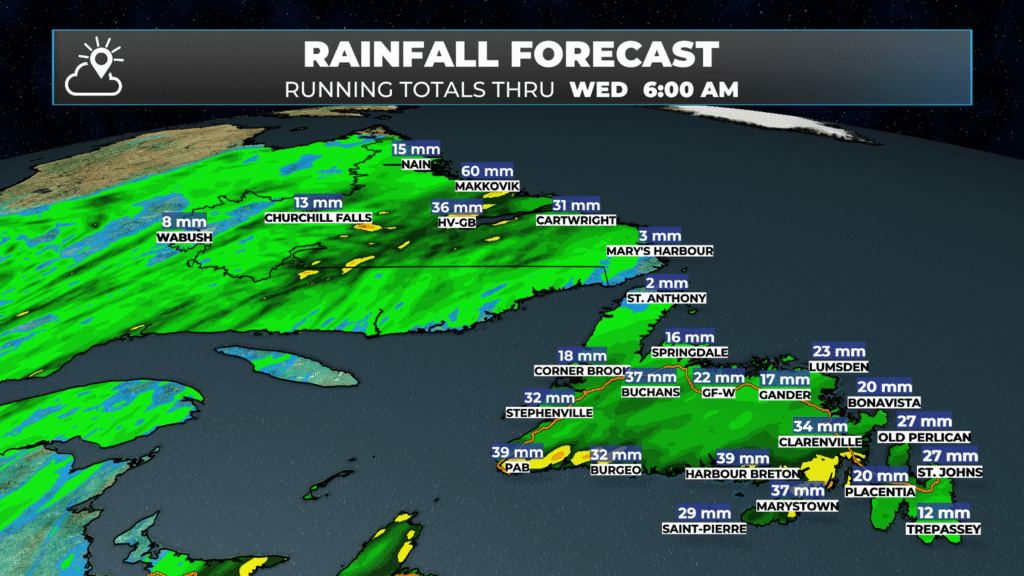
As you can see from the image above, most of the Province will see rain from later today through late Tuesday or Wednesday. Not all areas will see very heavy rain, which is why the alerts aren’t more widespread. I am hopeful that a large chunk of eastern Newfoundland, including the Paddy’s Pond and Kingston Fire zones, will see meaningful rain from this system.
Tropical Storm Fernand
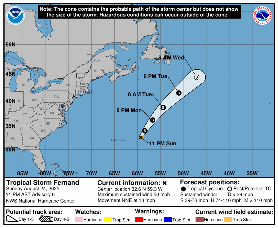
There is a new tropical storm in the Atlantic Ocean this morning, and its name is Fernand. The storm has max sustained winds of 85 km/h (50 mph) and is moving north-northeast at 20 km/h. The forecast track (below) for the storm shows it moving north and passing east of the Avalon Peninsula as a sub-tropical storm later this week. Currently, I don’t expect direct impacts from this storm, but there is a chance we may see some rain by mid-week if it passes close enough to the Avalon Peninsula. That’s a big IF right now.
My next update on what we can expect over the next few days will be up this afternoon. Have a great Monday, and stay safe!
Eddie
Great stuff !! Keep up the good work!
This is like Breakfast, best thing in the morning, starts the day off right, can’t do without and an healthy update.
Text. Thanks Eddie for the updates. Remember to look after yourself and your family. Blessings
Good morning Eddy 😊 a great forecast as always!
Tks Eddie. Appreciate all your updates 🤗
Very comprehensive! You put so much time and effort into these, fabulous, Eddie, thank you!
Professional forecasting as always. Great to see some rain.
Thanks Eddie!Great job…
Thanks Eddie. Looks forward to your weather App.
Good Morning Eddie
Love your weather app Eddie. Great job on keeping us up to date on both the weather and fires. All the best to you!
Thanks for your great website I love following your daily reports, keep it up Eddie
Your app proved to be so beneficial during the wildfire breakouts. It was my go to site for info. Very well done. I am sure there are many more who were grateful for the professional up to date and prompt reporting. Thanks so much.
Doris
Judy Ann
The first app I look at every morning , then I plan my day ! It’s great to be retired ! Have a great day Eddie and family 🌞
Can smell smoke here in Corner Brook this morning.
Is that related to the wildfires in NS?
Great to watch your daily reporting
Hi Eddie
Smelling smoke in Pasadena this morning. Any idea which fire it’s coming from?
Here in Corner Brook we’re all smoked out and we can even smell it in Hughes Lakes!
In the last 90 minutes the entire city of Corner Brook is engulfed in smoke. Can you please post some updates on this?