
Monday Morning Update — February 2, 2026
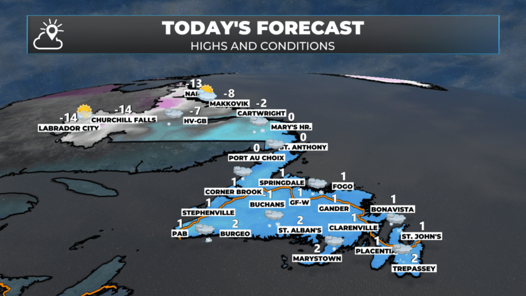
Today’s forecast – February 2, 2026
Good Monday Morning!
Here are today’s weather highlights:
A MAJOR Winter Storm will deliver heavy snow and high winds to eastern Newfoundland today and tonight. The snow will end early Tuesday morning. The heaviest snowfall rates will occur during the first half of the day.
Wind speeds will ramp up through the day in the east and northeast, and gust as high as 110 km/h over exposed areas this afternoon and evening, with locally higher gusts possible. The direction will be from the northeast, turning more north.
Orange and Yellow Winter Storm Warnings are in effect for much of eastern and central Newfoundland until Tuesday morning.
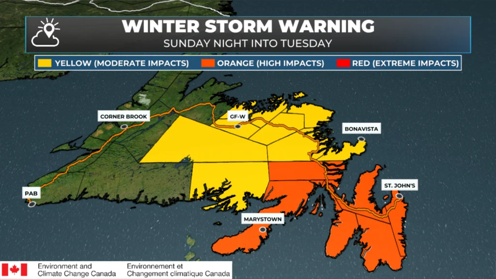
Winter Storm Warnings as of February 2, 2026 at 6 AM
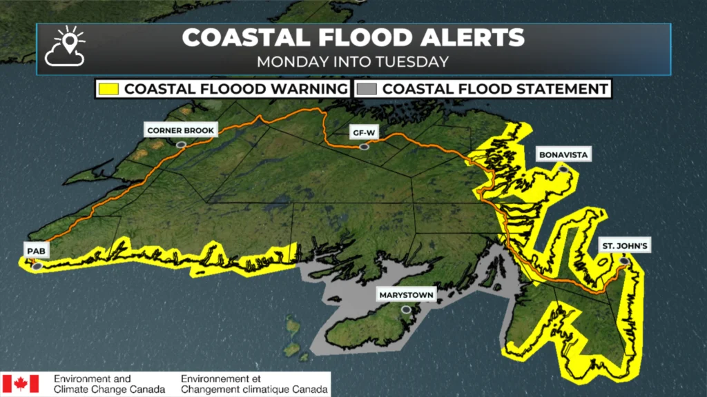
Coastal Flood Alerts as of February 2, 2026 at 6 AM
Coastal flooding is also a concern today, and Yellow Level Coastal Flood Warnings are in effect for much of the Island from Cape Feels eastward to the Avalon Peninsula and then from the southern Avalon to Port aux Basques. Expect higher than normal water levels at high tides today, tonight and Tuesday due to the combination of large waves, storm surge and strong onshore wind (on north-facing shores).
Snowfall totals are still expected to be quite high in the east and northeast, and on the Avalon, where 30 to 50 cm is expected by Tuesday morning.
The rest of the island will also see snow today, although it should’t be heavy from central back to the West Coast and GNP. Parts of Labrador’s mid coast will also see some snow today.
The radar loop (above) from this morning shows snow is falling heavily over much of eastern Newfoundland, with lighter snowfall rates to the west. The snow will continue moving west today, and we will watch the snow/ice area move north through the morning. The question is, how far north?
Future satellite and radar imagery shows that the line is moving up along the southern shore this morning and then back to the southeast this afternoon. That loop is below. That should also give you a good idea of the timing of this winter storm.
Today’s Forecast — Newfoundland
The St. John’s Metro:
Snow will be heaviest this morning, falling at 3 to 5 cm per hour until about 10 AM. Snowfall rates will lighten up after that and will continue in the 1 to 3 cm per hour range for the remainder of the day, and really until 4 or 5 AM Tuesday. There is a chance that parts of the Metro area, especially in the south, will see a transition to ice pellets and/or freezing rain late this morning or early this afternoon for a couple of hours. If that does happen, that will transition back to snow by mid-afternoon. The snowfall forecast range of 30 to 50 cm accounts for this as a possibility. Wind speeds will gust to 90 km/h this morning, to 105 km/h this afternoon and evening, and then slowly ease overnight. The direction will be northeast, turning north. Highs will be near 0º.
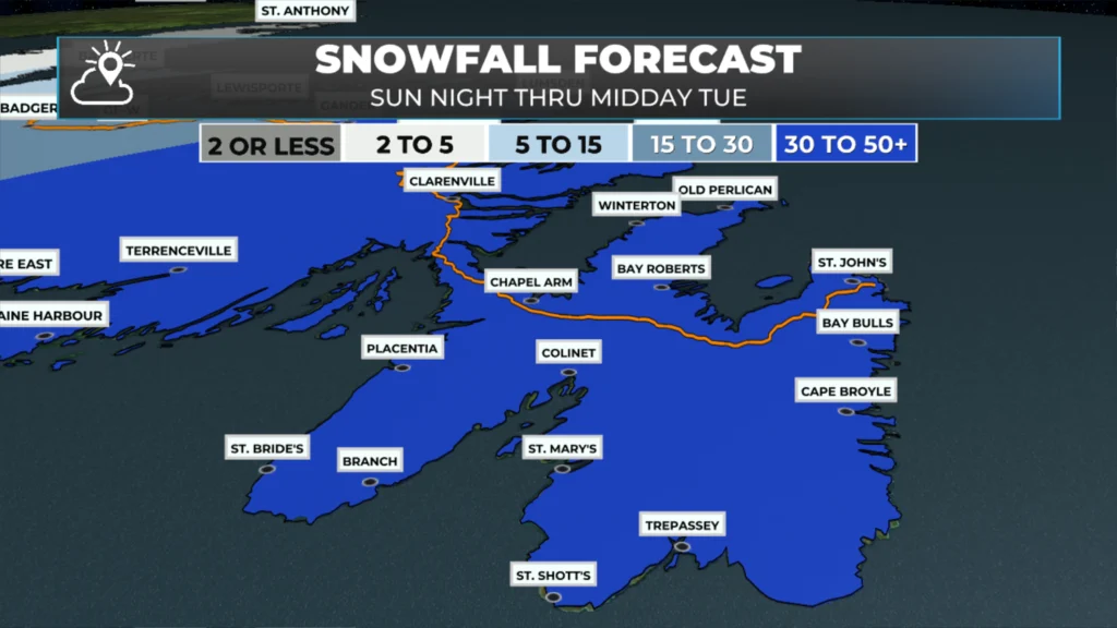
Today’s snowfall forecast for the Avalon Peninsula – Feb 2 to early on Feb 3, 2026.
The Avalon Peninsula
Snow will fall heavily at times this morning, especially before 9 or 10 AM. Snowfall rates will be in the 3 to 5 cm per hour range during this time. The snow will change to ice pellets and freezing rain in the south around or just after 6 AM. As the heaviest snow lifts north and west, and possibly off the Avalon, the snow will lighten up in intensity for most areas by noon — there is even the chance that a large part of the easternmost Peninsula changes to freezing drizzle as there may not be enough lift to drive snowflakes for a few hours. Don’t let that fool you, though, as it’s only a break. The snow will move in and intensify once more after about 3 PM, and it will continue until 4 or 5 AM Tuesday. Snowfall rates in this time shouldn’t exceed 2 cm per hour. High temperatures near 0º.
Wind speeds will ramp up throughout the morning, peaking this afternoon and evening. Gusts will be as high as 90 this morning, then as high as 110 km/h this afternoon and evening before slowly easing overnight. .
Eastern Newfoundland
(Burin Peninsula/Connagire, Clarenville/Terra Nova, Bonavista Peninsula and the Bonavista Bay area)
Snow will fall heavily at times today and tonight and will generally end by midnight. The Burin Peninsula will see the snowfall rates decrease late this morning. There may be some freezing drizzle there for a few hours from late morning into the afternoon, before the snow returns this afternoon and ends late this evening. Wind speeds gust as high as 100 miles per hour from the northeast and north. Speeds will gust as high as 120 km/h on the Bonavista Peninsula. Snowfall through much of this area will be 30 to 50 cm. The high winds will create areas of blowing and drifting snow, and visibility will be near zero in some areas. I expect the higher-end totals to be near Clarenville, the Bonavista Peninsula area and around Bonavista Bay. High temperature of 0º to -1º.
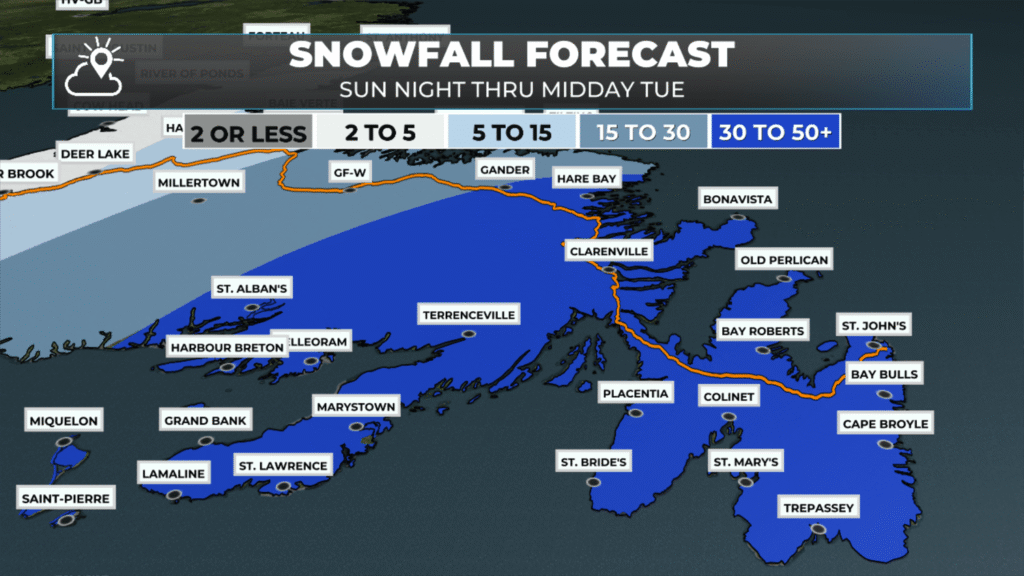
Today’s snowfall forecast for eastern Newfoundland – Feb 2 to early on Feb 3, 2026.
Northeastern and Central Newfoundland
Snow will fall throughout the day and will be heavy at times. Snow ends by midnight, and conditions will slowly improve overnight. Wind speeds will gust to 80 km/h in most areas, with locally higher gusts possible along the northeast coast. Snowfall in this area will be 15 to 30 cm, except in Gander northeastward to Greenspond, where 30 to 50 cm will fall. Likely closer to 30 cm than 50 cm, but… Gander does what Gander does sometimes, and this looks like a good setup for the plateau around the community. High temperature of 0º to -1º.
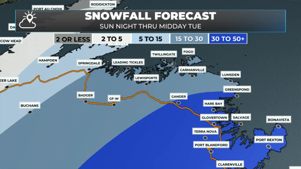
Today’s snowfall forecast for central/northeast Newfoundland – Feb 2 to early on Feb 3, 2026.
West Coast, South Coast and the Northern Peninsula
Periods of light snow today are expected to result in less than 10 cm across the area. In fact, less than 2 cm is expected over much of the Northern Peninsula today. Breezy with wind gusts as high as 80 km/h. Blowing snow over exposed areas will reduce visibility to near zero. High temperatures of -1º to -3º.
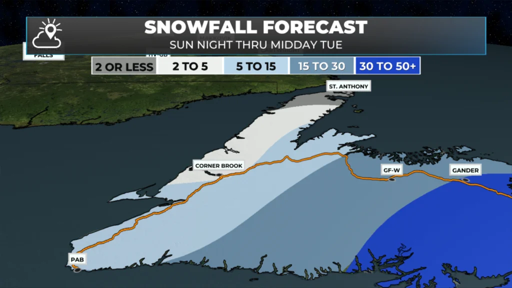
Today’s snowfall forecast for southern/western/ the GNP of Newfoundland – Feb 2 to early on Feb 3, 2026.
Labrador
Periods of snow along the coast today, especially from near Postville, southward toward the Straits. Snowfall is expected to be 5 to 10 cm today. It will be breezy, but wind speeds don’t look extraordinary in this area today.
Meanwhile, from Goose Bay to Labrador City and Wabush expect quite weather. Cloudy skies will rule in Goose while clear skies will take hold later in the day for Labrador West. Skies will go from cloudy to sunny between the two areas. Temperatures peak in the minus teens in the west to near 0 on the coast.
A potent winter storm looms for early next week… I’ll have my opinion on that and a full forecast for you posted later today. Meanwhile, don’t forget to check out the links below!
📱 Get the Sheerr Weather App in the Apple App Store and Google Play Store.
🗺️ Check out the Map Room to see all the latest weather observations for the Province.
🎥 Check out the Provincial Highway Cams to see 👀 what’s going on around our highways and
Is there another system for Thursday for avalon
Good morning Eddie. Thanks for the very early update.. we really appreciate your hard work.
Thanks for the update, Eddie. Start safe out there.
Great job Eddy… I remember Snowmaggedon… you were right then and you’re right now… have a wonderful day!
Good Morning Eddie. It’s a nasty one for sure I hope you’re able to catch a nap throughout the day, you deserve it! Thanks so much for your dedication!!!
Good Morning Eddie & Thanks for the update. Windy and wet snow here in Pouch Cove. Stay safe everyone
Good morning Eddie, thanks for weather update.
Thanks Eddie! I hope you got some sleep!
Thanks for the update Eddie.