
Monday evening’s forecast — Hot weather sticks around on the Island, cools a bit in Labrador
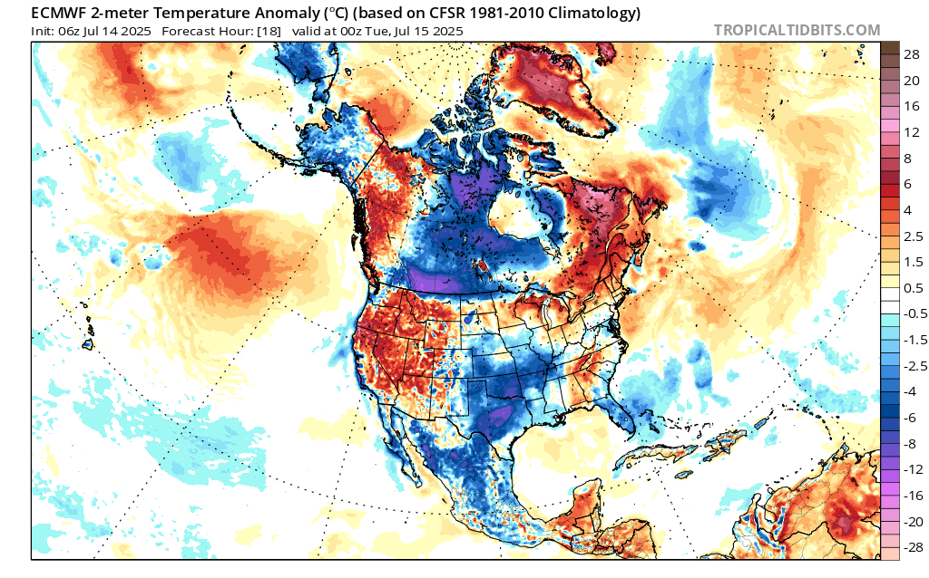
We remain under a high-pressure regime. Also known as a heat dome. This has brought unseasonably warm air to much of the region over the last couple of days, and that will continue for the next couple of days. The image below shows temperature anomalies, or how much higher or lower the temperatures are compared to the average. Note all the red over Atlantic Canada? That’s from the dreaded ‘heat dome’!
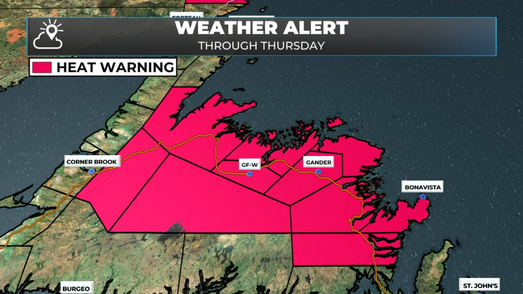
And that heat dome means there has been no shortage of heat across the Province today. Many areas were close to 30ºC this afternoon, including St. John’s. As of 2:30 PM, the high measured at the airport of the Province’s capital was 30.0ºC, which is just 0.6º off the record for the day, set in 1963. Heat Warnings are in effect for much of the Island and will likely continue through Wednesday and possibly Thursday, as highs for many areas will remain in the upper 20s to lower 30s.
To get the forecast for you area, be sure to visit the forecast pages! Or better yet, download my FREE weather app!
Labrador will see the heat break, to a point, today as a cold front comes through. That cold front is going to drive some fairly intense showers and thunderstorms between Upper Lake Melville and the coast later today and tonight. Ahead of the front, the ECCC NL Weather Office in Gander has issued a Severe Thunderstorm Watch (as of 3 PM Monday) for that area.
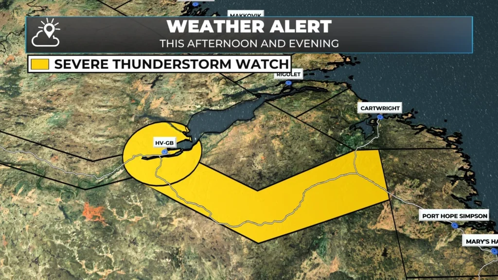
Severe Thunderstorm Watch area as of 2:20 PM ADT
Short-range forecasts indicate that the storms will be passing through the area between 4 PM this afternoon and 10 PM this evening. Once those showers clear that part of Labrador, skies will slowly clear off. The mugginess will be slow to decline but it will overnight and tomorrow should be much more comfortable across the Big Land.. but it will be warm again with highs in the upper 20s for Goose Bay points east and southeast—cooler air returns to the north and west, with highs in the upper teens to low 20s. Cooler air makes a more widespread return Wednesday, with upper teens and lower 20s becoming the norm.
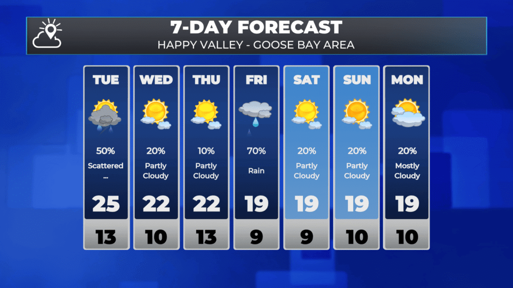
To see the 7 day for your area click the image or be sure to download the app!
Weather Highlights across NL for the next 5 days
More showers and thunderstorms move through southeast Labrador Tuesday afternoon, some will be strong, like today.
Hot weather sticks around on the Island through Thursday, before a reprieve arrives.
No major weather-makers in the cards this week, but there will be scattered showers around the West Coast the next 2 days and then into Central on Thursday.
A low may bring widespread rain to Labrador between Friday and Saturday.
Any end in sight for the fire ban?
thanks eddie!
Thanks Eddie!
Thanks Eddie! The App is very much needed. I find the Env. Can. App very vague for a weather but like myself! Your app is only here for a little while and it’s already the best one! Congratulations!
Really enjoying your app. ☀️⛅️🌦️🌤️
Thank you Eddie. Not looking forward to the heat at my workplace tomorrow and the rest of the week 🥵
Loving the page and app already! Thanks!
Loving the app! Deleted the others!!
Love the app, Eddie. Not so much the heat, though. Then again, a few months from now, we’ll all be begging for this heat. Have a good night. Thanks for the update.
I love the app. As always clear, concise, knowledgeable and prompt. Thank you.
Great app Eddie. Thank you
Eddie love the app and the Heat
Appreciate all of the work you are putting into this. It’s great 👍
I love this app! Congratulations Eddie.
Awesome will see you tomorrow bright and early Eddie 👍🌸
Great App, loving it Eddie, thanks for all you do 😊
Excellent Job Eddie with your new weather App. Very informative and detailed forecast. I like that Sheer Weather covers our local provincial weather and forecasts.
Love your app. Congratulations Eddie
Loving this app Eddie!
Loving ur new website Eddie 👏👏
Congratulations ❤️
Great stuff Eddie…love the app!
Awesome app, love it.
Congratulations on your new app! Downloaded, and ready for your daily updates 🙂