
Friday Morning’s Weather Briefing — November 13, 2026
Good Friday Morning!
- A quiet, chilly start, with temperatures of -2° to 5° this morning across NL, with the coolest readings in eastern and central Newfoundland.
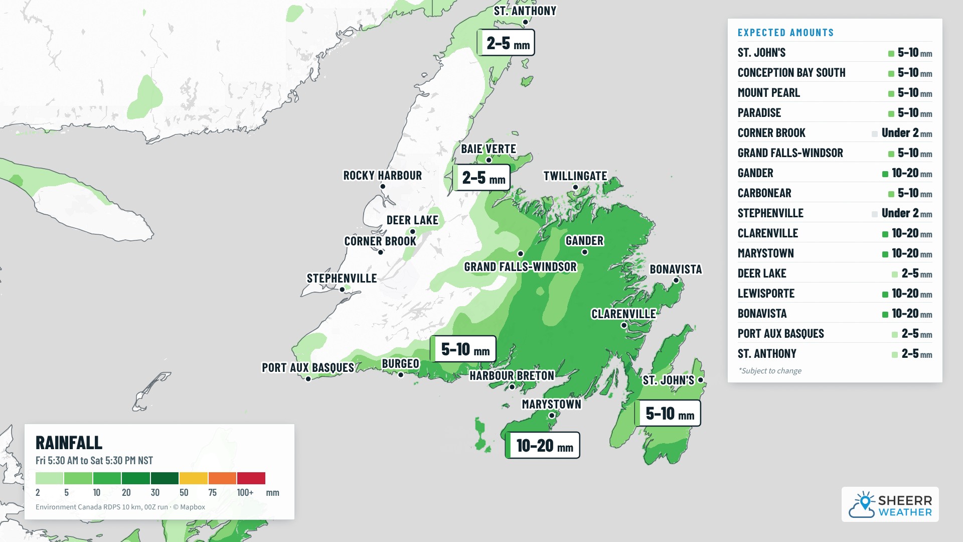
- Enjoy the morning, because it won’t last. Another low brings rain to the south coast, the Avalon and the northeast coast this afternoon and tonight, with 5 to 15 mm for most areas.
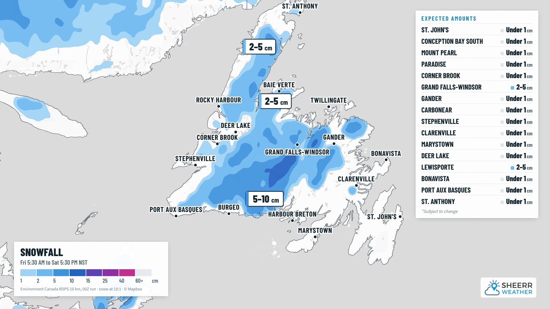
- Rain mixes with and changes to wet snow in northeast, central and western Newfoundland this evening and tonight, mainly inland and over higher terrain. Much of the area will see 2 to 5 cm, with 5 to 10 cm over the hills north of the south coast and across much of interior Newfoundland.
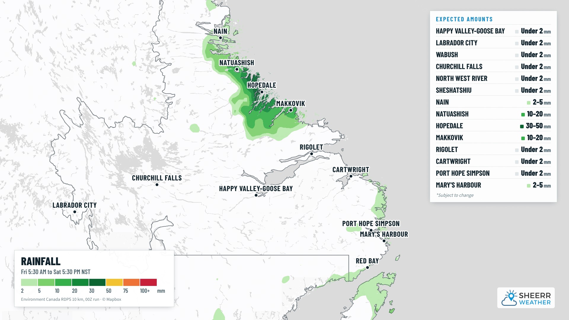
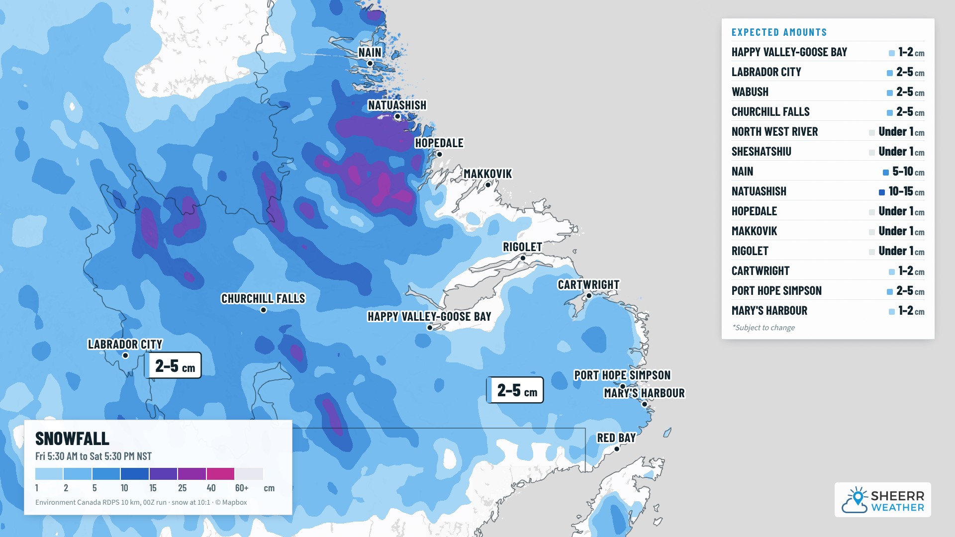
- In Labrador, light snow continues in Lab West and Churchill Falls, with a few more centimetres, while the north coast gets a soaking rain: about 40 mm around Hopedale by Saturday evening, with snow just inland.
- Things settle down on the Island by Saturday evening, with nicer weather heading into Sunday.
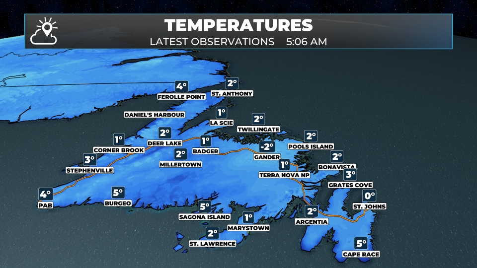
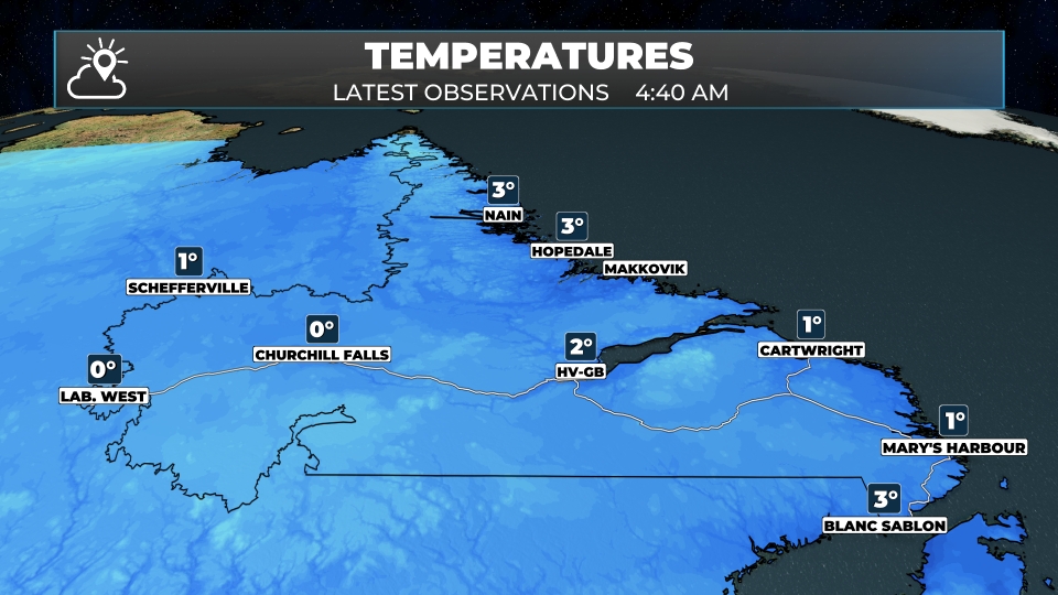
It’s a quiet, chilly start to Friday on the Island, with partly cloudy skies and temperatures of -2° to 5° this morning. The coolest readings are located over parts of eastern and central Newfoundland, so watch for a few icy patches as you head out the door. The warmest spots are along the south coast, with 5° in Burgeo. Labrador is between 0° and 3° this morning, with the warmest readings in the north and south.
Don’t let the quiet start fool you. The next low is taking shape to our southwest, and clouds thicken this morning ahead of it. Rain develops along the south coast late this morning and spreads across the Avalon, the Burin Peninsula and the northeast coast this afternoon, becoming steady by late afternoon and evening. Most areas pick up 5 to 15 mm by Saturday, with the most around Bonavista, Gander and Harbour Breton. The wind picks up tonight too, with gusts near 60 km/h on the Bonavista Peninsula.
In central and western Newfoundland, it’s a mix of rain and wet snow this afternoon, changing to snow this evening and tonight, mainly inland and over higher terrain. Grand Falls-Windsor and Lewisporte could see 2 to 5 cm, and the hills north of the south coast could get 5 to 10 cm. Around Corner Brook, Deer Lake and Gander, it’s a centimetre or so, mainly on grassy surfaces. On the Northern Peninsula, snow showers develop tonight and continue Saturday, with 2 to 5 cm over the higher ground.
The map below shows the expected snowfall totals as of late last night. Overnight guidance has shifted the snowfall forecast slightly east, so this may need adjustment; places like Gander may end up in the 2 to 5 cm range, whereas this map shows less than 1 cm.
In Labrador, it’s 0° in Lab West and Churchill Falls this morning, with snow showers through the day and tonight, about 2 to 5 cm by Saturday evening. Goose Bay starts with snow this morning, turning to showers of rain and wet snow this afternoon, with just a centimetre or two. The north coast gets the heaviest precipitation: rain in Hopedale today and tonight, about 40 mm by Saturday evening, with gusty northeast winds this afternoon. Just inland and north of Hopedale, it’s snow, with 10 to 15 cm around Natuashish and 5 to 10 cm in Nain, and heavier amounts over the higher terrain. Southeastern Labrador gets light snow on Saturday, with 1 to 5 cm along the coast.
This morning’s update is sponsored by Amplifon Hearing Care Experts, formerly Newlife Hearing!
Book your hearing aid Test Drive today at amplifon.com or call (709) 800-7343!
Eastern Newfoundland / the Avalon: Cloudy with rain developing this afternoon and a high near 6°. Southeast winds of 15 to 30 km/h. A steady rain this evening, then a few showers overnight, about 5 to 10 mm in all, with a low near 4°. Showers this morning, becoming a steady rain this afternoon around Placentia, with a high near 6°. Rain this afternoon on the Bonavista Peninsula and around Clarenville, with highs near 6°, and windy tonight on the Bonavista Peninsula, with east winds of 30 to 50 km/h. Lows of 2° to 4°.
Central: Cloudy this morning, with light rain and snow this afternoon and highs near 5°. Rain and snow this evening, with 2 to 3 cm possible in areas that switch over, changing to showers of rain and wet snow overnight. Lows near 0° to 1°.
West Coast: Rain and snow showers this morning in Corner Brook and Deer Lake, then rain showers this afternoon, with highs of 5° to 6°. Snow this evening, with lingering snow showers overnight, mainly over the hills. Showers this morning in Stephenville, becoming a steadier rain this afternoon, with a high near 5°. Rain showers in Rocky Harbour, with a high near 5°. Lows of 1° to 2°.
South Coast: Periods of rain today around Harbour Breton, Marystown and Burgeo, about 10 to 12 mm, with highs near 6°. Occasional showers tonight, with lows of 2° to 4°.
Southwest / Wreckhouse: Rain likely in Port aux Basques, about 6 mm, with a high near 5° and southeast winds of 15 to 30 km/h. Showers this evening, then cloudy overnight, with a low near 2°.
GNP and the Straits: Rain and snow this morning in St. Anthony, then cloudy this afternoon, with a high near 4°. Cloudy around Port au Choix, with a high near 5°. Rain and snow showers this evening, changing to snow showers overnight, with lows of 1° to 2°.
Labrador / the Big Land: Snow showers in Labrador City and Churchill Falls today and tonight, a few centimetres, with highs near 2°. Snow this morning in Goose Bay, then showers of rain and wet snow this afternoon, with a high near 3°. Rain and snow showers this morning in Cartwright and Mary’s Harbour, with highs of 3° to 4°. Rain in Nain, mixing with snow this afternoon, and periods of rain in Hopedale, about 12 mm today and more tonight, with northeast winds of 25 to 40 km/h. Lows tonight of -2° to 2°.
Looking ahead: Saturday starts with fog and a few showers in the east, then turns mild, with highs near 9° to 10° on the Avalon. Snow showers linger on the Northern Peninsula and in central Newfoundland in the morning, and southeastern and northern Labrador get more snow, with rain and snow continuing on the north coast. The weather turns nicer across the Island on Sunday.
📱 Get the Sheerr Weather App in the Apple App Store and Google Play Store.
📍 Want more detail for where you live? Check out our new Regional Forecast pages for current conditions, local alerts, highway cams and the forecast for your area: Avalon · Eastern · Burin Peninsula · South Coast · West Coast · Long Range Mountains · Central · GNP & the Straits · Labrador West · Central Labrador · Labrador North Coast · Labrador South Coast
🗺️ Check out the Map Room to see all the latest weather observations for the Province.
🎥 Check out the Provincial Highway Cams to see 👀 what’s going on around our highways.