
Friday Morning’s Weather Briefing – May 22, 2026
This morning’s update is sponsored by Roebothan, McKay, Marshall.

Visit MakeTheCall.ca today to learn more about how the law firm can help you!
Good Friday morning!
Here are today’s highlights:
It’s a brilliant start to the day on the Island with lots of sun and temperatures near 0ºC.
Labrador is still dealing with lots of clouds, temperatures near or below freezing and snow along parts of the coast and in the west. As of 5 AM ADT, both Churchill Falls and Wabush Airports were reporting light snow.
Highs on the Island reach 6ºC to 10ºC today, under mostly sunny skies. There will be some rain/wet snow on the Northern Peninsula by mid-afternoon.
Rain and snow persist along the Labrador Coast until this evening.
Showers and light rain will be found from Green Bay – White Bay through central and northeast Newfoundland and the Bonavista and Avalon Peninsulas overnight before ending early Saturday morning.
Special Weather Statement Remains In Effect
A Special Weather Statement remains in effect for the following areas until this afternoon:
Nain and vicinity
Hopedale and vicinity
Postville – Makkovik
According to Environment Canada’s alert, up to 5 cm of additional snowfall is expected today, with more in the backcountry and high terrain. The snow is expected to change to rain showers or flurries this afternoon. Strong northwesterly winds will cause reduced visibility in blowing snow, especially over exposed areas.
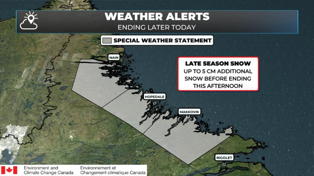
A Special Weather Statement remains in effect until this afternoon for northern Labrador, from Postville to Natuashish. May 22, 2026.
Newfoundland Today
Sunny skies this morning will persist across most areas today. Highs will reach 6ºC to 10ºC. It will be breezy, with gusts up to 75 km/h from the west. Wind speeds will be higher in higher terrain.
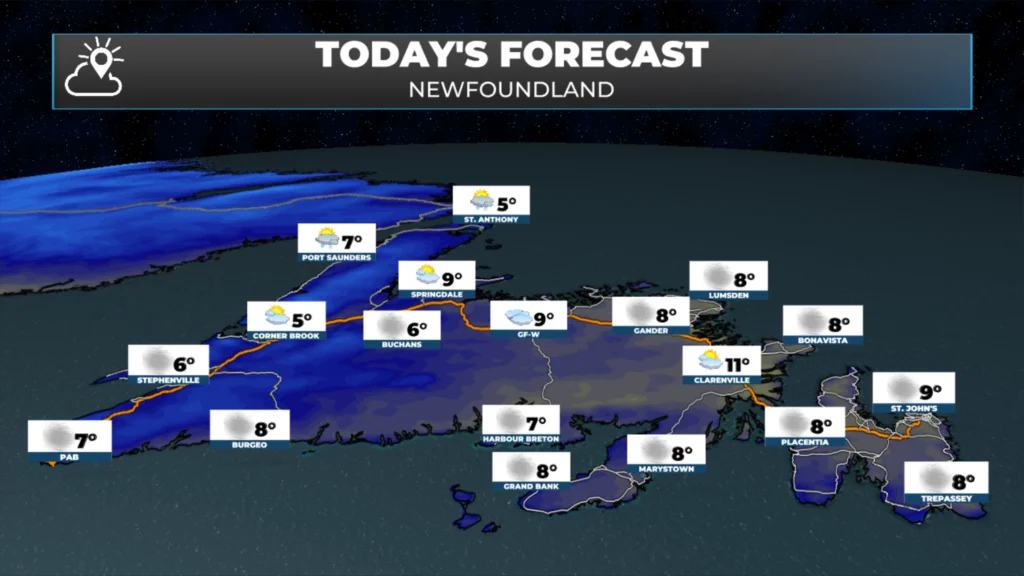
Newfoundland’s forecast for today – May 22, 2026.
The Northern Peninsula and parts of the West Coast north of Corner Brook will see cloud cover later this morning, with rain arriving in the afternoon. Rain will mix with wet snow just inland, and inland areas over higher terrain will see more wet snow than rain. This will continue into tonight before ending. Areas farther east, along and near the facing shores from Green Bay-White Bay to the Avalon, will see rain (and possibly west snow inland and over higher terrain) and showers arrive overnight, then end early Saturday morning. The animation below shows this very well.
Snowfall amounts will be light on the Island, except over the highest peaks of the Long Range Mountains, where totals may exceed 10 cm by Saturday morning. While it’s not a full-fledged late-season winter storm, it’s worth noting if you have a cabin in the high country of the Northern Peninsula.
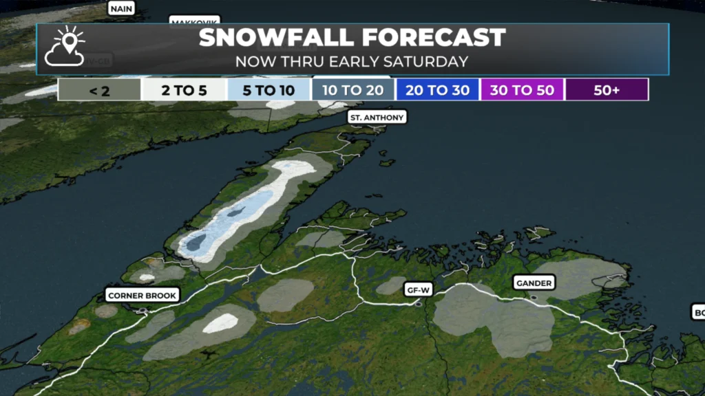
Expected snowfall between later today and early Saturday morning – May 22, 2026 into May 23.
Labrador Today
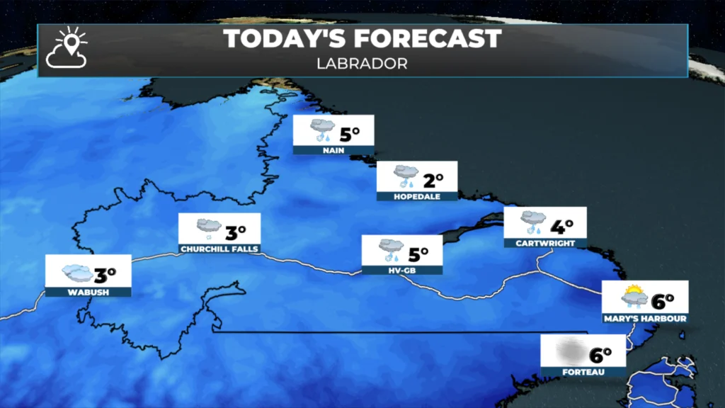
Labrador’s forecast for today – May 22, 2026.
Cloudy with areas of showers and/or flurries in the west and extending into the Happy Valley-Goose area. Along and near the coast, expect areas of snow and rain this morning, shifting to more rain than snow by the afternoon as slightly warmer air arrives from the east. The precipitation will begin to shut down this afternoon and evening, moving from north to south. Skies will clear overnight. Highs today remain in the lower single digits across most of the Big Land. This animation of future radar and satellite imagery paints the picture well.
The weekend currently looks great across much of NL and I’ll have an update on that for you later today!
📱 Get the Sheerr Weather App in the Apple App Store and Google Play Store.
🗺️ Check out the Map Room to see all the latest weather observations for the Province.
🎥 Check out the Provincial Highway Cams to see 👀 what’s going on around our highways and
Good morning Eddie beautiful sunny day , have a wonderful day
Good sunny morning Eddie
Thanks Eddie
Nice to see the sun but it definitely chilli outside this morning.
Thanks Eddie
Good Morning Eddie,
Windy & Chilly here in Botwood this morning. Enjoy your weekend.
Good morning Eddie .
Let’s keep the sun and toss
the wind.