
Friday Morning’s Weather Briefing — March 27, 2026
Good Friday morning!
Here are today’s weather highlights:
Rainfall and Wind Warnings are in effect for southeastern Newfoundland through today, and Blowing Snow Advisories are in effect for coastal Labrador. An Extreme Cold Warning is in effect for Labrador West overnight into Saturday morning. Find all the alert details right here!
All alerts are Yellow Level at this time
Heavy rain will continue to fall over eastern Newfoundland, particularly on the Burin and Avalon Peninsulas during the first half ot today.
Areas to the west will see lighter rain, rain mixed with snow or just snow once you near western Newfoundland, the GNP and southeast Labrador.
Conditions start to improve on the West Coast, South Coast, and through Central by early afternoon, while the rain will continue over the Avlaon until this evening, although it will become less intense throughout the afternoon before it ends.
Temperatures will fall once the rain and snow end (in all areas), as that signals the passage of a cold front. That will happen first on the West Coast this morning and last on the East Coast (this evening).
Today’s Outlook
An area of low pressure and its associated cold front will move across the island and southeastern Labrador today. Ahead of the front, there will be areas of rain over much of southern and eastern Newfoundland. The rain will be heavy at times on the Burin and Avalon Peninsulas until early or mid-afternoon. Areas farther west will see either snow or a rain/snow mix ending this morning or by early afternoon on the island, and by evening in southeastern Labrador. The animation below, which shows future radar and cloud cover, will depict this very well and should give you a better idea of how this is playing out.
The ending of the rain or snow will signal that a cold front has passed, and temperatures will start to drop shortly thereafter. On the West Coast and in GNP, the stratoform snow and/or rain we are seeing this morning will be replaced by onshore flurries and snow squalls this afternoon as the cold air establishes itself. Farther east, the sharp drop in temperatures will not occur until later today or this evening. The animation below shows how the temperatures will drop across the region through the day. You will notice the bitterly cold air in Labrador making its way to the southeast
Rainfall amounts today will be the most significant in the southeast and on the Avalon, where Yellow Level Rainfall Warnings will remain in effect until this evening. Rainfall amounts over many areas will be between about 30 and 70 mm, with locally higher amounts likely over the southern areas of the Avalon. Localized flooding is a good bet.
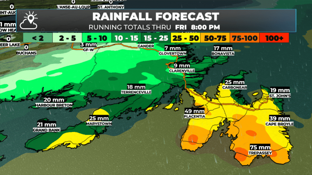
Forecast rainfall amounts from this morning through the evening.
The other notable feature today will be high wind speeds over eastern Newfoundland during the first half of the day. Winds will gust from the south as high as about 100 km/h over exposed areas. Wind speeds will start to slacken this afternoon and will become more normal overnight as the wind direction changes behind the cold front passage. Parts of coastal Labrador will also see high wind speeds today. The animation below shows how the wind speeds will play out today.
Much colder air moves in for the weekend, and there will be some light snowfall over the eastern parts of the Island Saturday night into Sunday morning. I’ll have an update on this weekend’s forecast later today.
📱 Get the Sheerr Weather App in the Apple App Store and Google Play Store.
🗺️ Check out the Map Room to see all the latest weather observations for the Province.
🎥 Check out the Provincial Highway Cams to see 👀 what’s going on around our highways and
Good morning Eddie thanks for the update, have a wonderful day
Thanks Eddie,
Looks like windy, wet and wild day on the Avalon. Buckle up
Thanks Eddie for update. Stay dry and enjoy your weekend 😁
Thanks Eddie for the update
Good morning Eddie,thanks for weather update.
Look forward to your forecasts everyday
Do you anticipate ferry delays tonight? Or just rough crossing?