
Friday Morning’s Weather Briefing — February 6, 2026
This morning’s radar loop shows a little bit of light snow over eastern Newfoundland and the Avalon Peninsula. While this will not add up to more than a couple of centimetres, it will make roads a bit slippery in spots. Be sure to check the highway cams and the 511NL.ca site to see what the roads look like.
Good Friday Morning!
Here are today’s weather highlights:
Some snow is moving across eastern Newfoundland this morning. As that moves offshore, I only expect isolated flurries across the rest of NL today. Skies will be partly cloudy to mostly sunny across the Province.
Highs reach the minus single digits on the Island and minus teens in Labrador. The west will be closer to -20ºC. Luckily, wind speeds will be light for the most part.
An area of low pressure will pass southeast of the Avalon Peninsula tonight and Saturday. The Avalon Peninsula will see snow from this feature, and this morning it looks like eastern areas, including the Metro, could see 5 to 10 cm of fairly fluffy snowfall. I hate using words like could and should instead of will, but thereis a chance the snow remains offshore and hardly anything falls. Check back later today for an update on this one.
Snow will return to coastal Labrador on Sunday, which is the start of a milder pattern for NL. Check out yesterday’s forecast for a bit more on that
Newfoundland’s forecast for Friday
Light snow over the Avalon and flurries just to the west will move offshore, to the east, this morning and behind it I only expect isolated flurries for the remainder of the day. Skies will be partly cloudy to mostly sunny, and highs will be in the minus single digits. Wind speeds should not be much of an issue today. Overall, it looks like a pretty decent mid-February day!
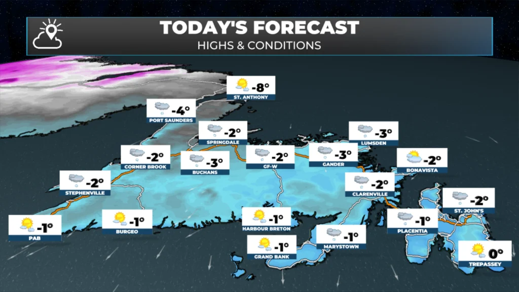
Newfoundland’s forecast for February 6, 2026.
Labrador forecast for Friday
Partly cloudy to mostly sunny skies will be the rule in Big Land today as high pressure dominates the region’s weather. Expect highs in the minus teens to near -20ºC this afternoon.
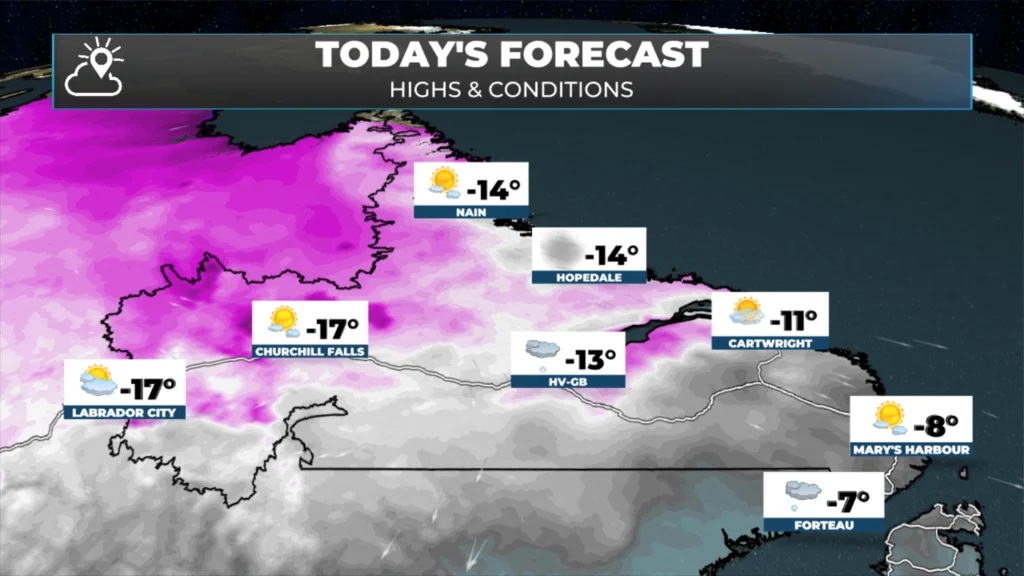
Labrador’s forecast for February 6, 2026.
Watching Tonight and Saturday…
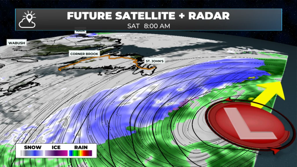
Watching this low between tonight and Saturday – February 6 into 7, 2026
A low-pressure area will pass east of the Avalon Peninsula between Friday night and Saturday. This low looks to remain far enough offshore that its significant snowfall should also remain east of the Southern Shore. That said, it looks like parts of the Avalon Peninsula, especially in the east, may pick up 5 to 10 cm of snow between later tonight and Saturday.
In this time frame, I hate to use words like could or should instead of will, but in this case, there is still some uncertainty. Take the two computer model images below as an example: one shows all the snow offshore, and the other shows some onshore. In this range, I tend to favour the RDPS model over the Euro…
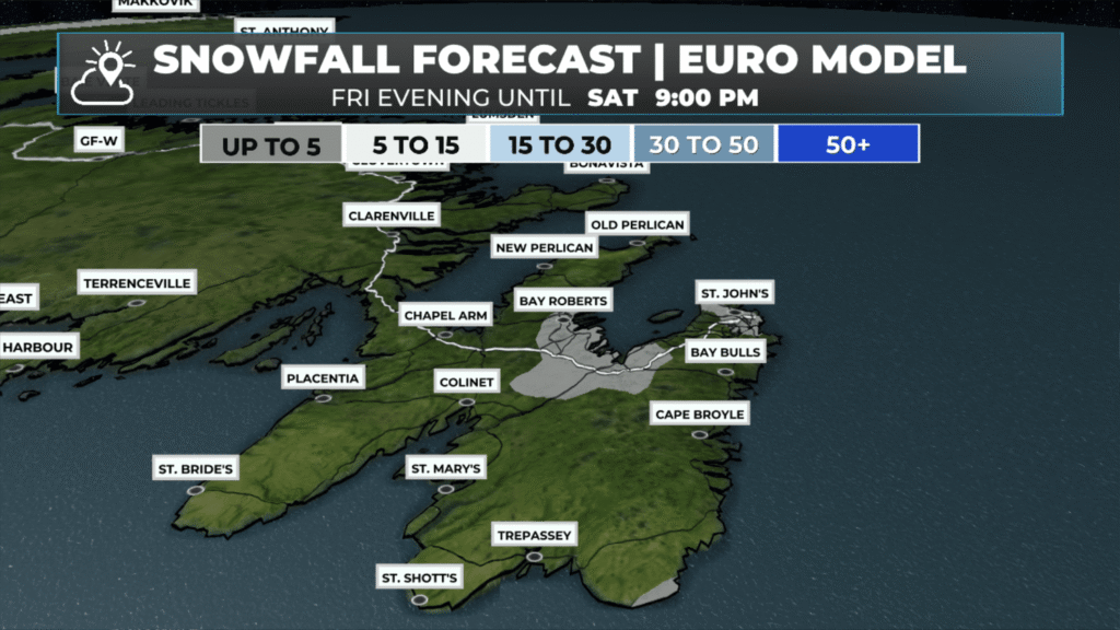
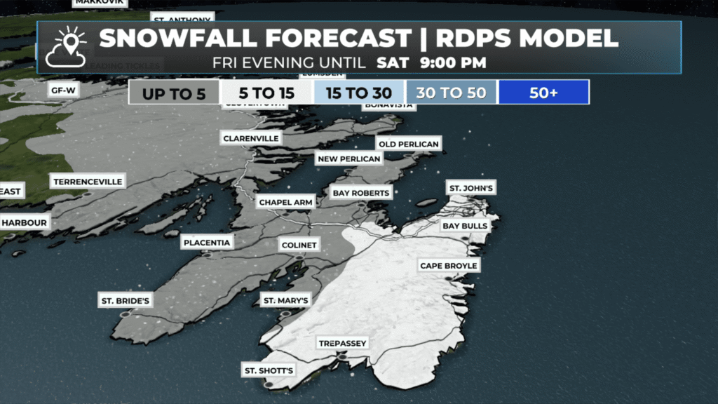
I also know that showing you two computer models like this makes it seem like I’m uncertain. Well, in this case I am, and I’m trying to lay out the possibilities and explain why this uncertainty exists. It’s one of those systems where a small difference in track can have a relatively significant difference in our weather.
This should become clearer this morning and afternoon with successive updates in the weather data, and by this evening, I hope to have a better handle on what we can expect tomorrow.
Stay tuned.
I’ll have updates for you throughout the day!
📱 Get the Sheerr Weather App in the Apple App Store and Google Play Store.
🗺️ Check out the Map Room to see all the latest weather observations for the Province.
🎥 Check out the Provincial Highway Cams to see 👀 what’s going on around our highways and
Thanks Eddie!
Good Morning Eddie. Thanks for the update. Will definitely be checking in later to get your latest update on our overnight forecast
Have a good day!
Good morning, thank you for the forecast. Anyone who can predict Newfoundland weather with 100% certainty would have to be God 🙂
Good morning Eddie, thanks for weather update.
Thanks Eddie