
Friday Morning’s Weather Briefing — August 21, 2026
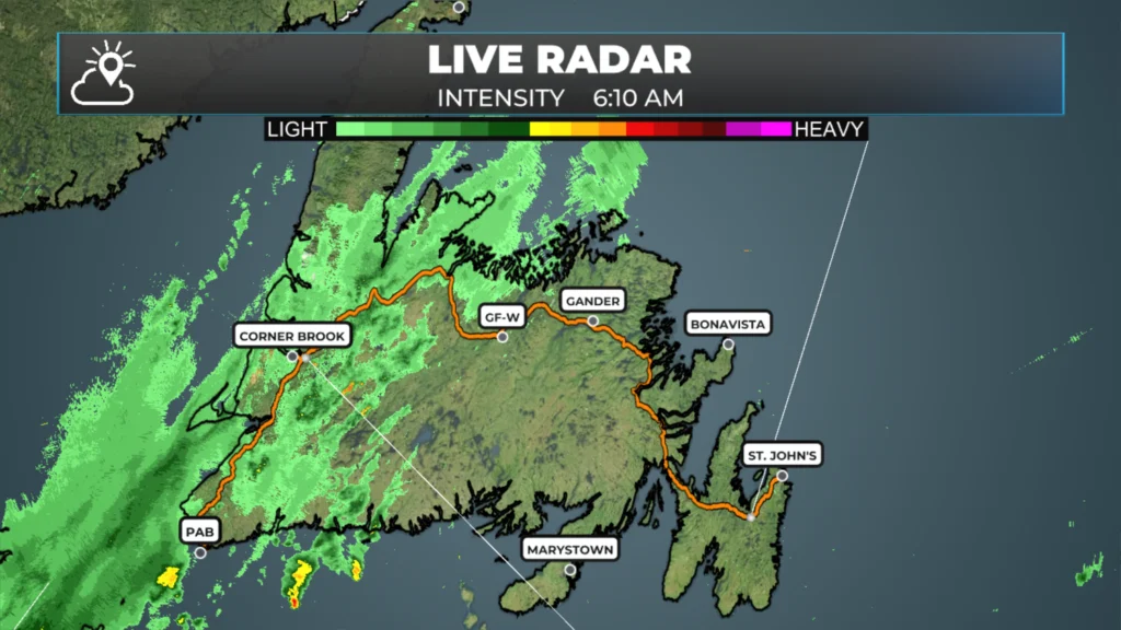
Radar image showing showers and light rain across western and southwestern Newfoundland early Friday morning.
Good Friday morning!
We are seeing areas of showers over western and southwestern Newfoundland at this early hour (5:45 AM).
It’s a muggy, warm start to the day, with temperatures and dew points in the upper teens and humidex values in the low 20s.
The showers become less widespread through the day, and skies clear from west to east as a cold front moves through.
The cold front will push the muggy air offshore and replace it with a drier air mass between today (west) and tomorrow morning (east).
Morning showers end in southeast Labrador, and the Big Land will generally see sunshine today, with scattered showers and t’storms this afternoon.
Highs reach the teens and 20s across NL today, with humidex values making it feel higher in central and eastern Newfoundland.
This morning’s update is sponsored by Roebothan, McKay, Marshall.

Visit MakeTheCall.ca today to learn more about how the law firm can help you!
Eastern Newfoundland and the Avalon: A cloudy start with a chance of an early shower, then it breaks up through the day with highs in the low-to-mid 20s. It’ll feel closer to 30 with the humidity in the warmest spots, so it’s a sticky one. Saturday trends sunnier and just as mild.
Central: This is probably your best weather day on the Island — clouds give way to sunshine by the afternoon, with highs in the low-to-mid 20s. Saturday stays sunny and similar.
West Coast: A wetter start here, especially around Stephenville, where rain lingers into the morning before clearing out. Corner Brook sees its showers wrap up faster. Highs reach the upper teens to low 20s.
South Coast: Showers around Burgeo taper off by midday, then it clears in behind for a mild afternoon with highs near 20 to 22. Saturday brings abundant sunshine.
Southwest Coast: Rain in the morning around Port aux Basques gives way to clearing skies, with a bit of a breeze picking up behind it. Highs reach the low 20s. Saturday looks mainly sunny and just as warm.
The Great Northern Peninsula and the Straits: Clouds give way to sun throughout the day with highs in the low 20s, though it’ll be breezy. Saturday is sunny and pleasant again.
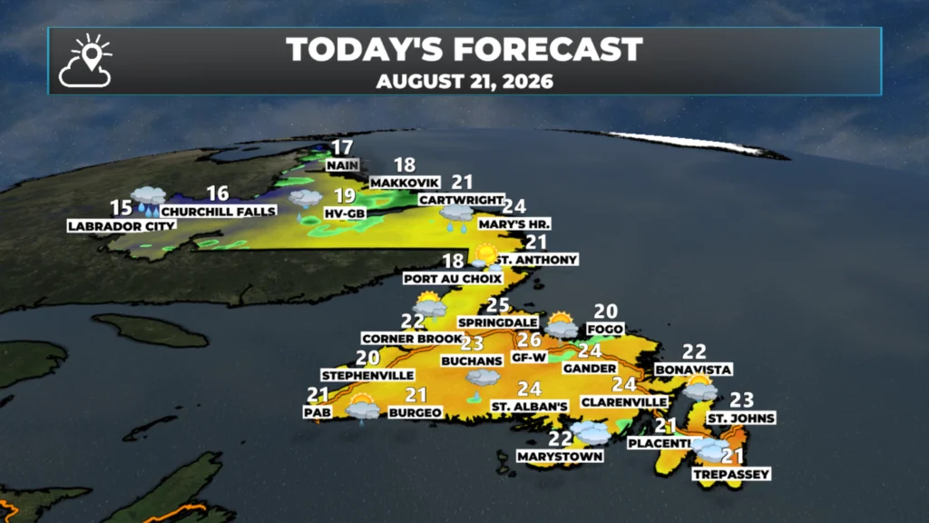
NL’s forecast for today – August 21, 2026.
Labrador, the Big Land: It’s a mixed bag out there today. Labrador West is the coolest spot in the province this morning and stays that way through the day, with highs only in the mid-teens under mostly cloudy skies — but it warms up nicely for Saturday. Central Labrador, around Happy Valley-Goose Bay, sees a few showers come and go with highs near 18 to 20 and a gusty southwest wind. The North Coast, around Nain, is the windy spot today, gusting into the 30s under a few clouds, with highs near 16 to 18 before showers move in later tonight.
Looking ahead, there’s no big storm on my radar for the next several days. The more active weather right now is well south of the border, where a stalled front is dumping flooding rain on Virginia and the Carolinas. There’s a chance a piece of that energy works north into the Great Lakes and Quebec by the middle of next week, which could set up our next system here — but it’s too early to pin that down. I’ll keep an eye on it and have more for you as the picture becomes clearer.
I am style eyeballing the early/mid part of next week as being quite hot across much of the Province as a brief ridge (or heat dome as some call it these days) tries to build in across the Island due to a large high-pressure center setting up shop southeast of Atlantic Canada. Highs may reach the middle and upper 20s, and the humidex would be in the mid-30s. Stay tuned.
My next update will be posted later today!
📱 Get the Sheerr Weather App in the Apple App Store and Google Play Store.
🗺️ Check out the Map Room to see all the latest weather observations for the Province.
🎥 Check out the Provincial Highway Cams to see 👀 what’s going on around our highways and
Good morning Eddie….Thank you for the update
Have a great Friday/weekend
Good morning Eddie thanks for the update, have a wonderful day
Good Morning Eddie. Thanks for update. Enjoy your weekend!!
Good morning Eddie, thanks for the update. Have a great day.
Good morning Eddie ! Thanks for the update Have a great weekend 😊
Thanks Eddie for weather update