
Friday Morning’s Weather Briefing — August 14, 2026
Good Friday Morning!
Areas of heavy rain and thunderstorms are currently located over southwestern Newfoundland and are just moving onto the West Coast.
As of just before 6 AM, rain is just starting to arrive on the Burin Peninsula and is now far from arriving on the southern Avalon.
A Rainfall Warning is in effect for southwest Newfoundland (see ticker above) for 40 to 60+ mm of rain today.
This is all due to a low-pressure area moving through that keeps rain going in many areas today, with possible thunderstorms and showers continuing into Saturday.
Quiet in much of Labrador today, with showers in the southeast.
Highs reach the teens and 20s – the Humidex will be in the 20s today.
This morning’s update is sponsored by Roebothan, McKay, Marshall.

Visit MakeTheCall.ca today to learn more about how the law firm can help you!
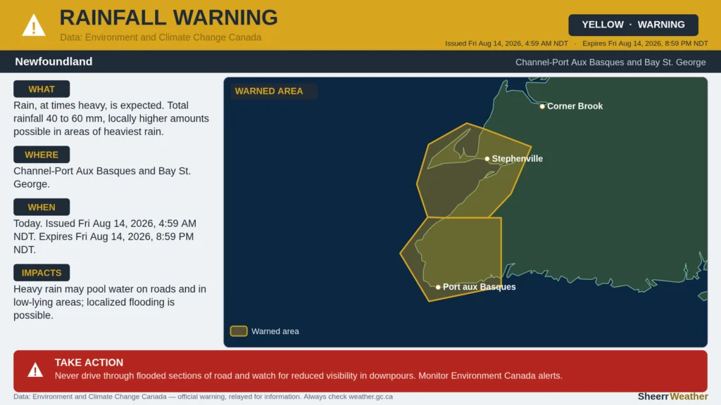
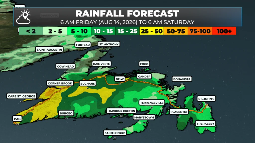
A low-pressure center is moving northeastward out of the Gulf of St. Lawrence and is dragging warm, humid air across much of NL today, and it’s going to be a wet one for most of the Island before things try to clear out tonight. A Rainfall Warning is in effect for the Southwest Coast — Bay St. George and the Channel-Port aux Basques area — where the heaviest rain is expected, generally 40 to 60+ mm with a risk of thunderstorms this morning. If you’re in that part of the Island, watch for ponding water on the roads and be ready for a soaker of a morning. Rain will fall in many other areas today as well.
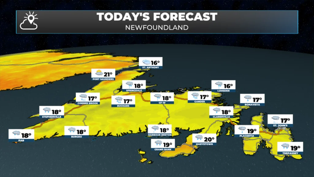
On the Avalon, look for rain moving in through the morning with a thunderstorm risk mixed in, and highs around 18. Central goes from a good chance of showers early to steadier rain by around noon, with a few rumbles possible this afternoon and highs in the upper teens. The West Coast is in for rain most of the day too, 10 to 20 mm with a thunderstorm risk, and winds swinging around to the northeast as the system slides by, highs in the upper teens. The Southwest Coast gets the worst of it, as noted above, plus winds that’ll pick up into tonight and tomorrow, gusting 25 to 40 km/h out of the northwest behind the low. The South Coast around Burgeo is also looking at a wet day, rain likely all morning tapering to showers tonight, highs around 18. On the Northern Peninsula and the Straits, it’s more cloud than rain through the day, with showers more likely tonight and into tomorrow morning, highs in the mid-teens.
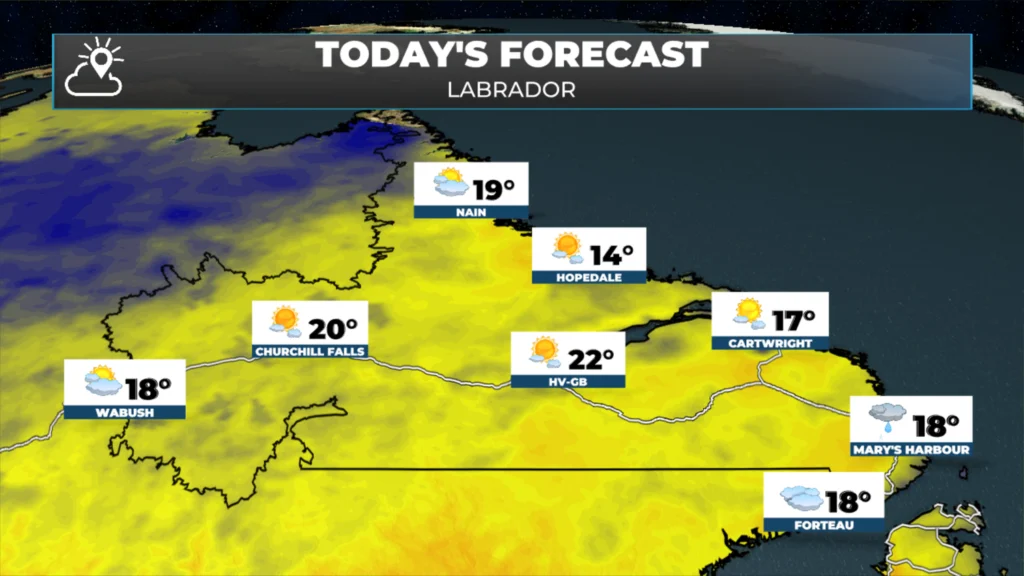
Over in Labrador, it’s a much quieter picture. The Goose Bay area are mostly cloudy with just a slim chance of a shower, and highs pushing into the low 20s — the warmest read anywhere in the Province today. Labrador West is mostly cloudy too, cooler, with highs around 18. The North Coast around Nain starts cloudy with some patchy fog, better clearing later, highs near 19 but lows dropping to the mid-single digits tonight. There will be some showers in the southeast and near the Straits.
Things dry out from the west overnight and Saturday is shaping up to be a much better day right across the Province — more sun, only scattered showers left over, and highs climbing into the high teens to low 20s almost everywhere. The Southwest Coast should see winds ease back too once the front clears.
My next update will be posted later today!
📱 Get the Sheerr Weather App in the Apple App Store and Google Play Store.
🗺️ Check out the Map Room to see all the latest weather observations for the Province.
🎥 Check out the Provincial Highway Cams to see 👀 what’s going on around our highways and
Good morning Eddie and thanks for the update
Good Morning Eddie !
A good day to stay inside and catch up on housework. Looking forward to a better day tomorrow. Thanks for update
Thanks Eddie.You do such an awesome job.👍👍