
Friday Morning Weather Briefing— February 20, 2026
Good Friday Morning
Here are today’s weather highlights:
Snow stopped falling at 11:30 PM last night, marking 48 consecutive hours of observations of snow falling at St. John’s International Airport.
5 cm of snow was also recorded at YYT yesterday, which brings the storm total to 50 cm at the airport.
The following Yellow Level Warnings are in effect this morning:
Blowing Snow
Green Bay – White Bay (Newfoundland – Saturday) – Snowfall: 15 cm | Gusts to 70 km/h
Cartwright to Black Tickle (Labrador – today) – Snowfall: 10-15 cm | Gusts to 60 km/h
Eagle River (Labrador – today) – Snowfall: 10-15 cm | Gusts to 60 km/h
Winter Storm
Great Northern Peninsula (Newfoundland – today into Sat) – Snowfall: 15-30 cm | Gusty winds accompany snowfall
Norman Bay to Lodge Bay (Labrador – this morning until Saturday afternoon): Snowfall: 20-30 cm | Gusts to 70 km/h
Snowfall
Red Bay to L’anse-au-Clair (Labrador – this afternoon into Saturday) – Snowfall: 10-15 cm (30 cm over higher terrain).
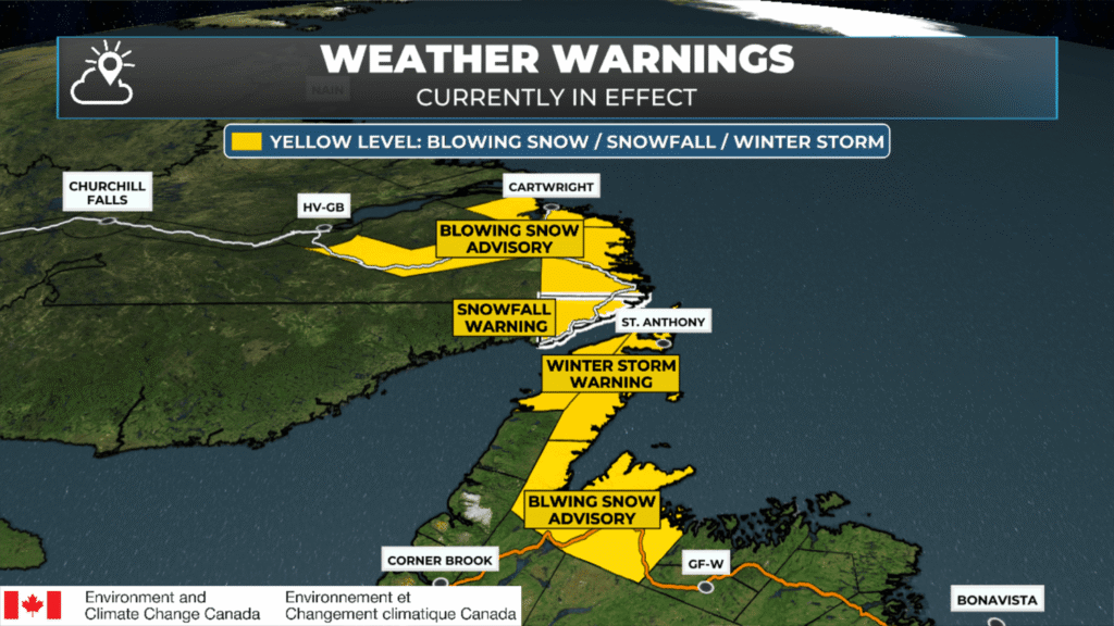
Weather alerts as of February 20, 2026 at 6:00 AM NST
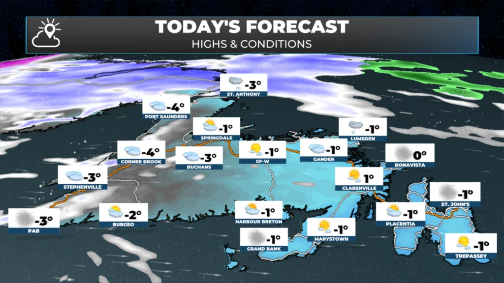
The weather across Newfoundland will be much calmer today compared to the last few days, as our area of low pressure has finally departed and the snow in the east and northeast has ended. St. John’s International recorded 48 consecutive hours of weather observations with snow falling! Expect highs in the single digits below freezing today. While it will not be as breezy as the last couple of days, wind chills will be into the minus teens thanks to wind speeds of 15 to 30+ km/h.
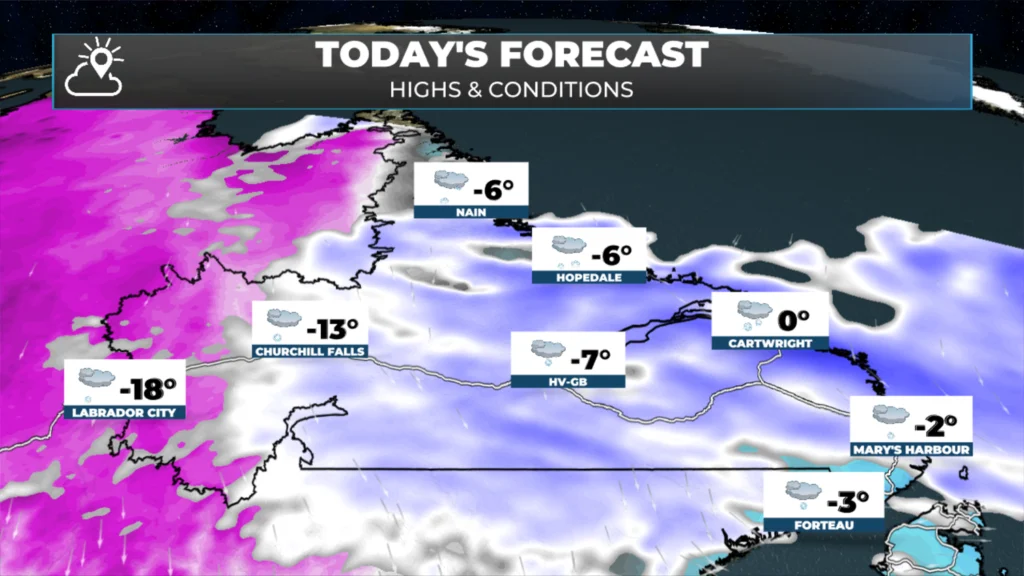
Labrador will see snow arrive this morning and that snow will sink to the south throughout the day, arriving on the Northern Peninsula this afternoon and evening. Snow will fly in much of this area today and tonight and on the GNP, into Saturday evening. While amounts will not be super high, a widespread 15 to 30 cm is expected in this area by tomorrow evening. Weather alerts are up (as you’ve seen above) and run through much of Saturday.
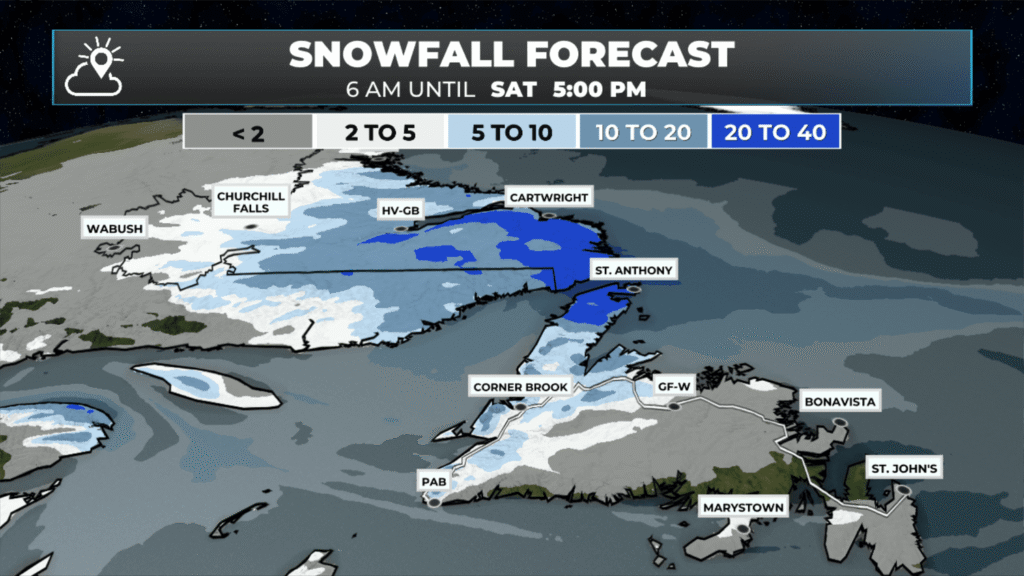
Snowfall expected to fall between 6 AM this morning and 5 PM Saturday evening (Feb 20 – 21, 2026)
Future radar and satellite show how the snow will evolve throughout the day, so that should help give you a good idea of what to expect, time frame-wise, in your area. In fact, we will see the snow become more widespread on the West Coast by Saturday afternoon.
Weekend Check In
An area of low pressure to our southeast and the system dropping in from Labrador will combine to bring another round of snow to eastern, northeastern and central Newfoundland Saturday night into Sunday morning. As it stands now, this will not be a major event, and barring any significant changes to the forecast snowfall totals, it should remain below 15 cm on the high end. That being said, it does look like the high end will fall on the Avalon once more, with lesser amounts to the west and north. I suspect Environment Canada will issue a blowing snow advisory or special weather statement for some of this area later today, as winds will gust to near 100 km/h from the north Saturday night into Sunday. Updates on this later today!
I’ll have updates for you throughout the day!
📱 Get the Sheerr Weather App in the Apple App Store and Google Play Store.
🗺️ Check out the Map Room to see all the latest weather observations for the Province.
🎥 Check out the Provincial Highway Cams to see 👀 what’s going on around our highways and
Thanks Eddie, for weather update
Thank you for the update. Have a great weekend!!
THANKS EDDIE FOR ALL YOUR UPDATES AND YOUR DOING A GREAT JOB AND HAVE A GREAT WEEKEND,STAY SAFE AND WARM.
Thanks for the update Eddie!
Thanks Eddie for your update! First morning I saw a blue sky with a few clouds since Tuesday in Carbonear! Enjoy your day and weekend 😊Not looking forward to more snow the weekend, but that’s all we can do about that hey 😆.
Good Morning Eddie! Thanks for update. The thoughts of more snow coming over the weekend is disheartening. It’s time for the sun to show its face! Enjoy your day Eddie
Cheers
Thanks Eddie for the update. Not looking forward to more snow!
Thank you, Eddie, for updates! Really appreciate it! Now let’s enjoy this beautiful day! God bless!
Thanks Eddie. I’m driving across tomorrow, so I guess I better get organized and up early to shoot thru Green Bay.