
Friday Morning Update — January 30, 2026
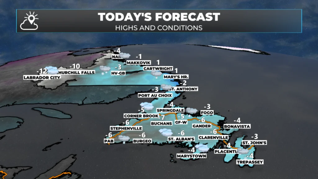
NL’s forecast for today, January 30, 2026
Good Friday morning!
Here are today’s weather highlights:
Snow continues along the Labrador Coast and over parts of western Newfoundland and the Northern Peninsula.
Orange and Yellow Level Winter Storm Warnings are in effect from Postville – Makkovik to Nain until early Sunday. Snowfall of 25 to 50+ cm is expected. The heaviest will occur this afternoon and tonight. Wind gusts reach as high as 80 km/ today and tonight.
Snow flurries and squalls are possible along the South Coast, Burin and Avalon Peninsulas this morning
Wind speeds pick up over eastern Newfoundland this morning and gust to 70 km/h as an area of low pressure intensifies offshore and departs..
The weather on the Island generally improves through the weekend.
The next major winter storm arrives Sunday night and will bring heavy snow and high winds to Newfoundland into Tuesday. Some areas of eastern Newfoundland may see a change to ice pellets and rain on Monday after heavy snowfall.
Today’s Forecast
Newfoundland
Scattered flurries and pockets of light snow across much of the Island today, under partly to mostly cloudy skies. Snow will be found on the Northern Peninsula and along much of the West Coast. That will become a little more widespread and more intense this afternoon. Snowfall amounts throughout the day will not be heavy, but some areas may see up to 15 cm, especially north of Port au Choix and in the higher elevations. There will also be a few bands of flurries or snow squalls over/near the South Coast, the middle of the Burin Peninsula and the southern Avalon Peninsula from this morning into the early afternoon.
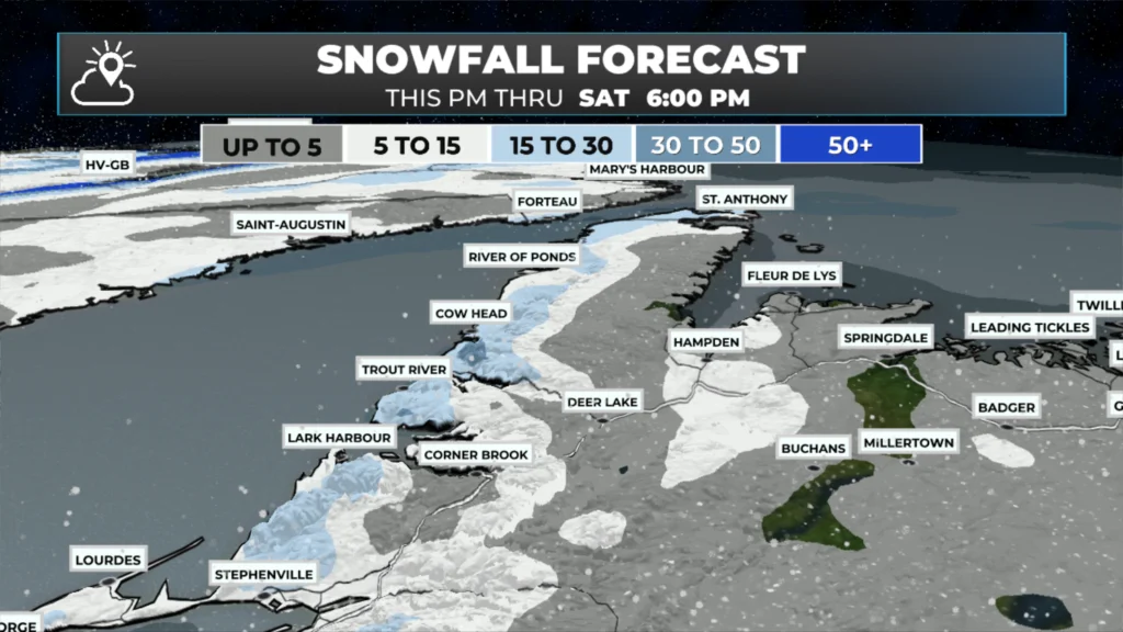
Snow on the West Coat from today through Saturday at 6 PM (JAN 30 – 31, 2026)
Highs today will be near -3ºC across the board, except inland and in the lower elevations, where readings will hover closer to -7ºC. Wind chills will be into the minus teens and their warmest.
Wind speeds pick up through the day and gust as high as 70 km/h late this morning for exposed areas in eastern Newfoundland. By late morning, the gusts will slack off and be around 60 km/h. <— Did you pick up the sarcasm there?!
Labrador
Areas of heavy snow will be found along the coast from near Cartwright to Nain today into Saturday. Snowfall amounts in this area will be 30 to 50 cm, with higher totals inland and over higher terrain. Wind speeds will pick up along the mid and north coast this afternoon through much of Saturday. Gusts will reach 80 to 100 km/h. This will lead to blizzard or blizzard-like conditions for an extended period. Yellow and Orange Level Winter Storm Warnings are in effect for this part of the coast into Saturday.
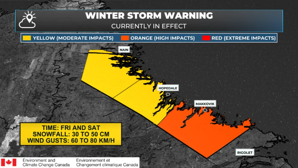
Winter Weather Alerts that are in effect as of January 30, 2026 at 5:51 AM AST
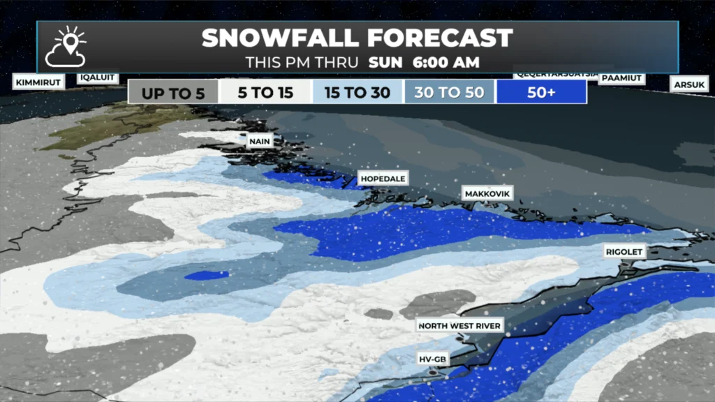
Snowfall forecast from today through Sunday morning (February 1, 2026)
There will also be some light snow around Happy Valley – Goose Bay at times today as well, espiecally in the higher terrain around the valley. The snow will continue into Saturday for much of Labrador (not the west) and will likely not end along the coast until Sunday morning.
Highs today will be near 0ºC along the coast and closer to -10ºC in the west. Happy Valley-Goose Bay will be near -3ºC.
A potent winter storm looms for early next week… I’ll have my opinion on that and a full forecast for you posted later today. Meanwhile, don’t forget to check out the links below!
📱 Get the Sheerr Weather App in the Apple App Store and Google Play Store.
🗺️ Check out the Map Room to see all the latest weather observations for the Province.
🎥 Check out the Provincial Highway Cams to see 👀 what’s going on around our highways and
Love your app. It keeps me informed for myself and family. Keep up the great work Eddie!
Thanks Eddie. I check your app daily for weather updates, especially when planning to drive across the island.
Good Morning Eddie! It seems winter is here to stay! Thanks for the update.
Good morning. Get weather reporting
Thanks Eddie for all you do..love your app…use it every day.
Good morning Eddie, thanks for weather update.