
Friday Morning Update — January 23, 2026
Good Friday Morning!
Here are today’s weather highlights:
Newfoundland & Labrador Hydro has issued a POWER WATCHthis morning due to the buildup of frazil ice in the Bay d’Espoir System. No action is needed by the public at this time.
Today will not be as cold as yesterday, but it’s still cold!
After a quiet morning, areas of flurries and pockets of light to moderate snow will develop over the Island.
A period of snow is likely over eastern Newfoundland late this evening into early Saturday morning (including the Metro area)
Very cold air returns tonight and settles in for the weekend, particularly Sunday
An Orange Level Extreme Cold Warning goes into effect Saturday morning for Labrador West, for wind chills as low as -50ºC.
My confidence is increasing of signfiicant snowfall over parts of Newfoundland Monday night and Tuesday, along with coastal Labrador

This update is sponsored by Roebothan, McKay, Marshall.
Visit MakeTheCall.ca TODAY to learn more about what the law firm can do for you.
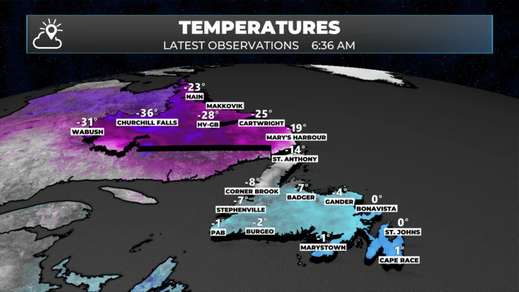
Observed temperatures just after 6:30 AM NST on January 23, 2026.
After last night’s snow and rain, Friday begins quietly across Newfoundland and Labrador. Temperatures as we head out the door range from near 0 in eastern Newfoundland to the minus 30s in Labrador West. Temperatures will moderate a bit today ahead of our next Arctic airmass, which moves in tonight.
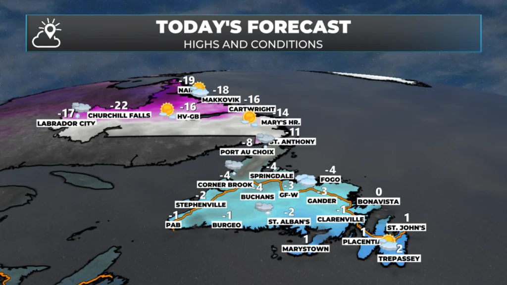
Today’s forecast – January 23, 2026.
Areas of light snow and flurries will develop over western areas this afternoon and will generally continue at times through the weekend as the sea effect snow machine turns on. A trough of low pressure will move over eastern areas tonight, which will bring 5 to 10 cm of snow to parts of the Avalon and Burin Peninsula and some adjacent areas of eastern Newfoundland. Future satellite and radar show how this will play out today and tonight very well.
Travel will be difficult in parts of western Newfoundland and the GNP over the next few days due to onshore snow. The bands will be particularly intense later today, tonight and Saturday. Keep that in mind if you’re heading to those areas. This will be especially true in exposed areas where snow and wind create blowing snow, significantly reducing visibility.
Speaking of wind, while it will be as windy as it was, it will be windy over the next few days, with gusts ot 50 to 80 common. This will put wind chills in the minus teens and 20s at the warmest, once we get past today. Long story short… enjoy today.
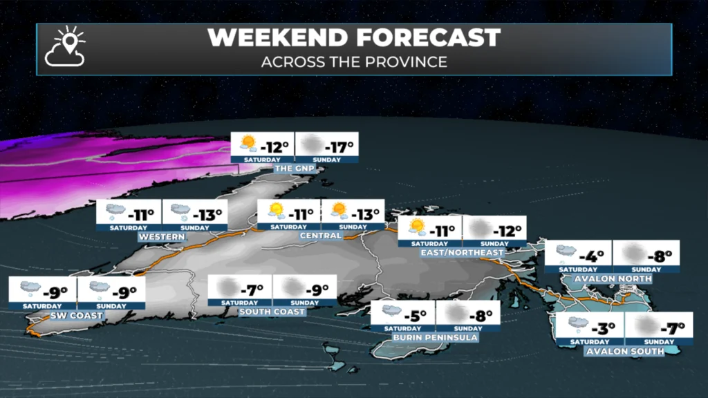
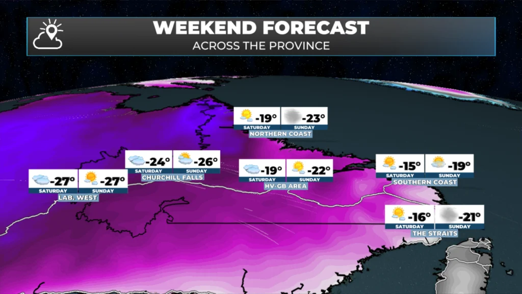
I’m watching the potential of a significant system early next week (Monday night into Tuesday). This is the same weather-maker that will bring heavy snow to the northeastern US this weekend. Details to follow!
I’ll have my next update on Friday’s weather, the weekend and beyond later today!
📱 Get the Sheerr Weather App in the Apple App Store and Google Play Store.
🗺️ Check out the Map Room to see all the latest weather observations for the Province.
🎥 Check out the Provincial Highway Cams to see 👀 what’s going on around our highways and
Good Friday morning Eddie!…Thank you for the weather update.
Have a great day & weekend!…Cheers
Good morning Eddie thanks for the update, have a wonderful weekend
Thanks Eddie
Thanks Eddie. Looking forward to your next update.
Thank you for keeping everyone informed and safe