
Coastal Flooding & Higher-Than-Normal Water Levels Expected Monday–Tuesday
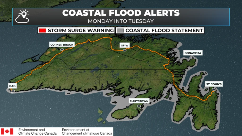
Coastal Flood Statements as of January 31, 2026 at 10 AM NST.
Higher-than-normal water levels are expected along several coastal areas of Newfoundland as a strong winter storm moves through early this week. The greatest concern will be around times of high tide, when storm surge and large waves combine.
Areas of Concern
Along the east and northeast coasts, impacts are possible along eastern and northeastern-facing shorelines from Cape Freels south to the Burin Peninsula.
On the south coast, a coastal flooding statement is in effect for areas from Channel-Port aux Basques eastward through Fortune Bay, including:
Western Coastline of the Burin Peninsula
Newfoundland Coastline: Connaigre
Newfoundland Coastline: Burgeo – Ramea – Grey River – Francois
Newfoundland Coastline: Isle aux Morts – La Poile
Newfoundland Coastline: Cape Ray – Channel-Port aux Basques
Timing
The risk window begins Monday morning and extends through Tuesday afternoon, with the most significant impacts expected near high tide.
High tide periods of concern:
Monday: 6:00 A.M. – 12:00 P.M. and 6:00 P.M. – 12:00 A.M.
Tuesday: 6:00 A.M. – 12:00 P.M.
South Coast peak: Monday morning, roughly 8:00 A.M. – 11:00 A.M.
What’s Driving the Risk?
Strong onshore winds will generate large waves and storm surge, pushing extra water toward the coastline. Wave heights are expected to reach 4 to 6 metres, with waves breaking as they approach shore.
There is potential for water levels to exceed the highest astronomical tide, particularly where storm surge and wave action line up with high tide.
Potential Impacts
Minor coastal flooding in low-lying areas
Coastal erosion, especially in exposed locations
Flooding or damage to wharves, roads, and other coastal infrastructure
Splash-over and wave run-up in vulnerable harbours and shorelines
Bottom Line
This is not a widespread major flooding event, but timing will matter. Communities that typically see issues during storm surge events—especially at high tide—should keep a close eye on conditions Monday into early Tuesday.
I’ll continue to monitor this system and provide updates if the risk level changes.
Thanks for keeping us updated Eddie…
Thanks ,Eddie for weather update
Good morning ☕️Eddie!…Thank you for the update!
Happy Saturday
Thank you Eddie for the update, don’t like it but it is winter. Not your fault.lol🤣
Thanks for the update….
Good morning Eddie thanks for the update, have a great day