GETTING TOWARD THE END OF ROUND 1 – CHRISTMAS DAY STORM
Good evening and Merry Christmas!
Sponsored
The weather across the Island, and now Labrador, has been stormy at various times throughout the day. While I don’t have exact snowfall amounts, it does seem like a widespread 15 to 30 cm has fallen across a large part of Newfoundland.
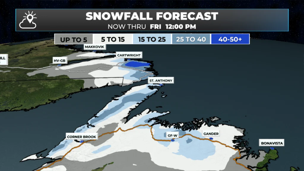
The snow will begin to end for most areas this evening, but it will take until almost tomorrow morning on the Northern Peninsula, and it will be nearly the end of the day for the coastal regions of Labrador. The map below shows the snowfall expected between now and midday tomorrow.
The snowfall forecast from now through 12 PM tomorrow (Boxing Day — 12.26.25). Click to enlarge.
Another thing to note tonight through tomorrow is powerful winds across the Northern Peninsula and parts of the Labrador coast. Forecast guidance indicates the potential for widespread gusts exceeding 115 km/h, increasing the risk of power outages. There is also a risk of wind damage. The animation below times out when the wind speeds are highest in your area.
NOTE NOT ALL AREAS ARE SHOWN DUE TO THE HIGH WINDS BEING FAIRLY LOCALIZED TO THE SHOWN REGION
ROUND 2 | BOXING DAY INTO WEEKEND STORM
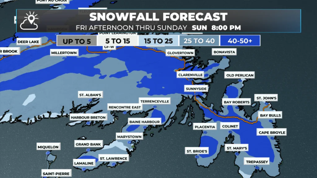
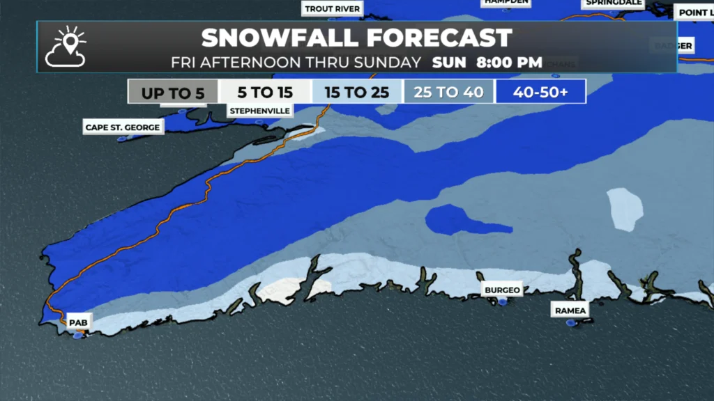
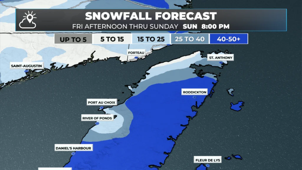
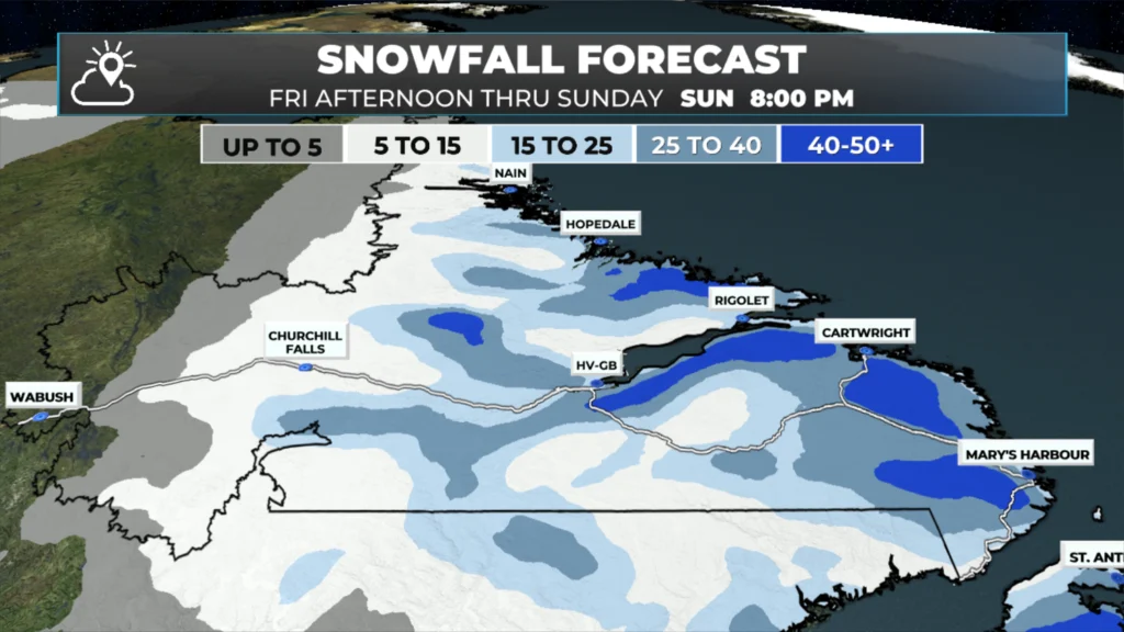
The next storm will arrive right after this one and will begin bringing snow to eastern areas of the Island tomorrow evening. At the earliest, it will begin around 5 or 6 PM on the southeastern Avalon, with arrival slightly later farther north and much later farther west. The storm will be potent, similar to the last one. However, there will be one main difference: speed. This system will move much more slowly, so there is potential for higher snow totals in many locations compared to what we saw today and will see tomorrow morning. On the Island, snow and rain will continue through Saturday and into much of Sunday. I say snow and rain because many parts of Newfoundland will see the snow change to rain at some point during this storm, but for the most part, that will happen after significant snowfall. In Labrador, the snow will arrive Saturday evening in the southeast and continue through Sunday. This system will also bring some wind, but wind speeds for most areas should stay below 100 km/h (unlike what we are experiencing tonight).
Regional Breakdown
The Avalon Peninsula
Snow arrives in the evening hours, between 5 and 7 PM. Snow will fall heavily overnight before changing to rain or drizzle between 4 AM and 7 AM. Snowfall rates will be intense overnight, and wind speeds will gust as high as 90 km/h. The combination of heavy snow and high winds will make travel difficult overnight.
There is some uncertainty in just how quickly the snow changes to rain, and subsequently, the range in the forecast is wider than I’d like to see.
Expected Snowfall: 20 to 40 cm (locally higher amounts possible — highest amounts inland over higher terrain)
The Burin and Bonavista Peninsulas, Clarenville, and Connaigre
Snow arrives between 7 and 9 PM and becomes heavy overnight. Snow will mix with and change to rain or drizzle between 9 AM and 11 AM Saturday. Wind speeds will gust as high as 90 km/h over exposed areas. Travel will be difficult until the change to drizzle or rain due to the combination of snow and wind.
Expected Snowfall: 20 – 40 cm (locally higher amounts possible — higher amounts inland and over higher terrain)
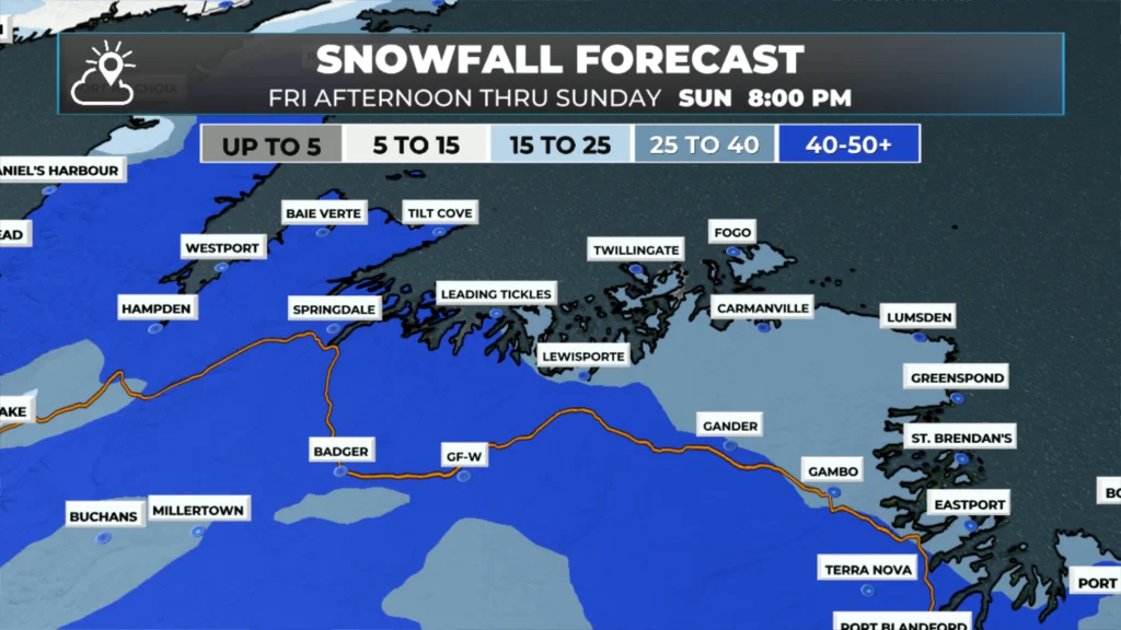
Northeastern Newfoundland (Terra Nova to near Gander and the coast from Bonavista Bay to Twillingate)
Snow will arrive between 9 PM and 11 PM and continue through 4 PM to 6 PM Saturday before changing to rain or drizzle. Wind gusts will reach as high as 90 km/h in exposed areas and along the coast. Travel will be difficult at times through this area until the change to rain or drizzle.
Expected Snowfall: 25 to 50+ cm
Central, Interior Newfoundland and the Green Bay – White Bay area:
Snow arrives by 11 PM and continues through Saturday, then changes to rain or drizzle or ends around midnight Saturday night, or a little after. Travel through this area will be difficult through Saturday due to heavy snowfall and high winds (gusts of 60 to 80 km/h).
Expected Snowfall: 25 to 50+ cm
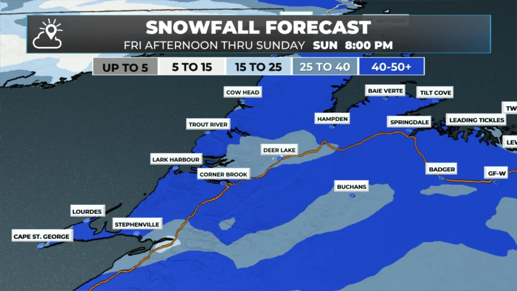
The West Coast, Southwest Coast, South Coast, and Northern Peninsula
Snow arrives between 2 AM and 4 AM Saturday and will continue into Sunday morning before tapering to flurries or changing to rain (Northern Peninsula). Wind speeds will gust as high as 90 km/h in exposed areas.
Expected Snowfall: 25 to 50 cm (lower amounts on the south and southeast coast — closer to 15 to 25 cm)
Labrador
Snow arrives late Saturday afternoon and continues through Sunday before ending. Some areas near the Straits to Rigolet will see a change to rain Saturday night, then back to snow, ending as flurries late Sunday. Wind speeds will gust up to 90 km/h over exposed areas.
Expected Snowfall: 15 to 45+ cm (more inland and over higher terrain)
I’ll have my next update posted Friday afternoon at the latest!
⚠ Storm ModeGet warnings pushed to your phone the moment they’re issued.Get the app
By using this website, you agree to our use of cookies. We use cookies to provide you with a great experience and to help our website run effectively. Privacy Policy

Thanks Eddie for weather update
Thanks Eddie, and a Merry Christmas to you and your family.
Thx, Eddie. Suppose to be flying out of YYT at 5:45 p.m. tomorrow. Fingers crossed.
Thanks for the updates, Eddie
Will, it’s certainly a white Christmas!!