
Rain, Wind and Snow in Remembrance Day’s Forecast for Newfoundland and Labrador
This evening’s forecast is sponsored by CU Financial Management
Expert financial advice across Newfoundland and Labrador, with an expanded office now open at 39 Pippy Place in St. John’s. Visit cufm.ca to learn more!
Remembrance Day: dress for rain
Tomorrow is Remembrance Day, November 11, and I wish I had a better forecast for you for most of Newfoundland. In St. John’s, as the parade starts at 10:10 tomorrow morning and we get toward 11 o’clock, when the official ceremony begins at the National War Memorial, we’re looking at 6°, rain and breezy, with winds gusting to about 40 km/h. If you’re heading out to a ceremony, be sure to dress accordingly.
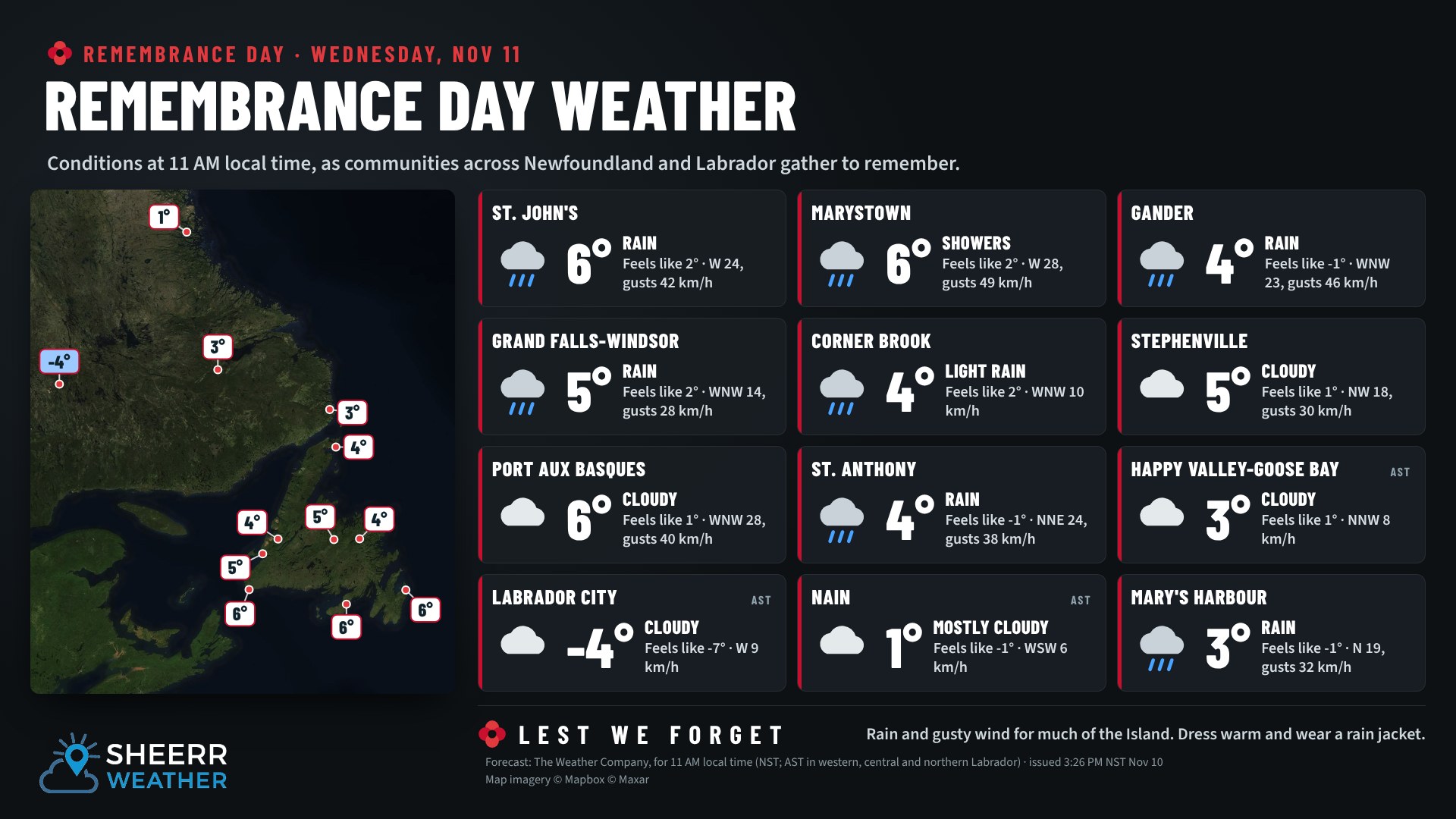
Across the rest of the province at 11 AM, it’s generally cloudy, with pockets of rain across eastern, central and western Newfoundland and the Northern Peninsula. The south coast and much of Labrador stay dry, but it’s cold in Labrador, especially in the west, with -4° in Labrador City at 11 o’clock. As you go out to remember those who gave their lives so we can have the freedom we have today, dress for the weather. Lest we forget.
Rain tonight, then snow on the way
The rain for tomorrow’s ceremonies rolls in overnight with an area of low pressure that slowly works its way through the province from southeast to northwest, a bit of an unusual track. Not only will it bring rain, it brings some wind, and snow to Labrador and potentially to parts of central and western Newfoundland by tomorrow afternoon, especially inland and over higher terrain.
Some of that rain has already moved into the extreme western Avalon, the Burin Peninsula, Clarenville and up toward the northeast coast. One low is spinning through Labrador into Quebec, while another is taking shape to our south, and that’s the one that plays the big role in our weather from tonight through tomorrow, and into Thursday in some areas.
By 6 AM, moderate to heavy rain moves across the Avalon Peninsula, through Clarenville toward the Bonavista Peninsula, up toward Lumsden and the Fogo area. Rain also falls from Bay d’Espoir and the Connaigre region up through Buchans, Corner Brook, Deer Lake and Rocky Harbour, and into the Lower North Shore of Quebec. As the low moves north and west, so does the rain, with heavy rain in southeast Labrador by midday.
By midday, the rain lightens up in eastern Newfoundland, but snow starts to show up on the map and expands through the second half of the day. As the low intensifies, it pulls in air that’s just cold enough for snow, not in the lowest terrain, but above about 60 or 70 metres. It’ll be a wet snow. Snow falls near Corner Brook and on parts of the West Coast, though right along the Gulf it’s likely a sloppy rain and snow mix. By 6 PM tomorrow, wet flakes are likely in Grand Falls-Windsor and Gander, possibly mixed with rain. It’s very borderline.
By midnight tomorrow night, the snow moves back into Churchill Falls, and tomorrow afternoon and evening it snows quite heavily for a while in the Goose Bay area. By Thursday morning, warmer air settles into Labrador, with the rain and snow line between Goose Bay and Churchill Falls, and much of the coast is mild. On the Island, a few flurries linger in western Newfoundland Thursday morning. It’s chilly, but not overly cold: this low doesn’t have a ton of cold air to work with, just enough for snow in spots.
How much rain?
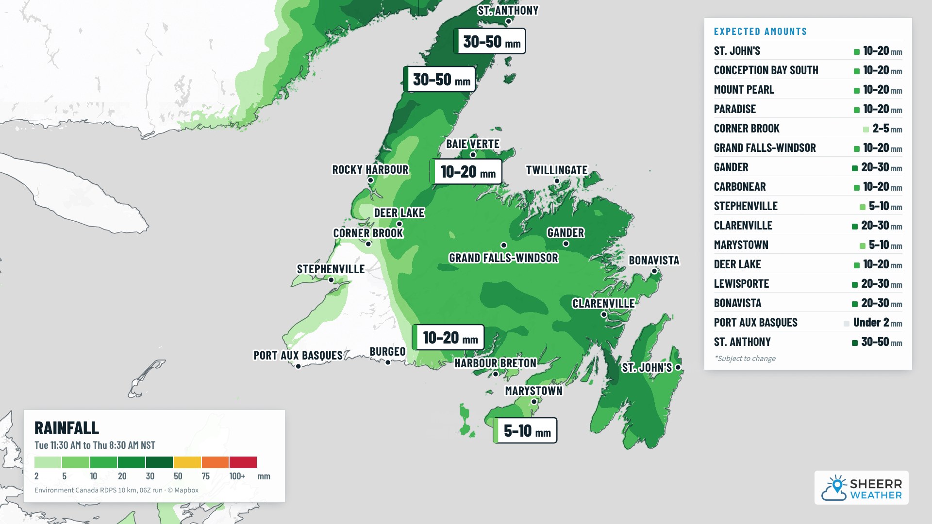
Significant rain falls in spots: 20 to 50 mm on the Northern Peninsula, the northeast coast and parts of the Avalon, with the highest amounts on the Northern Peninsula. Southwestern Newfoundland sees the least, with hardly any rain at all.
How much snow?
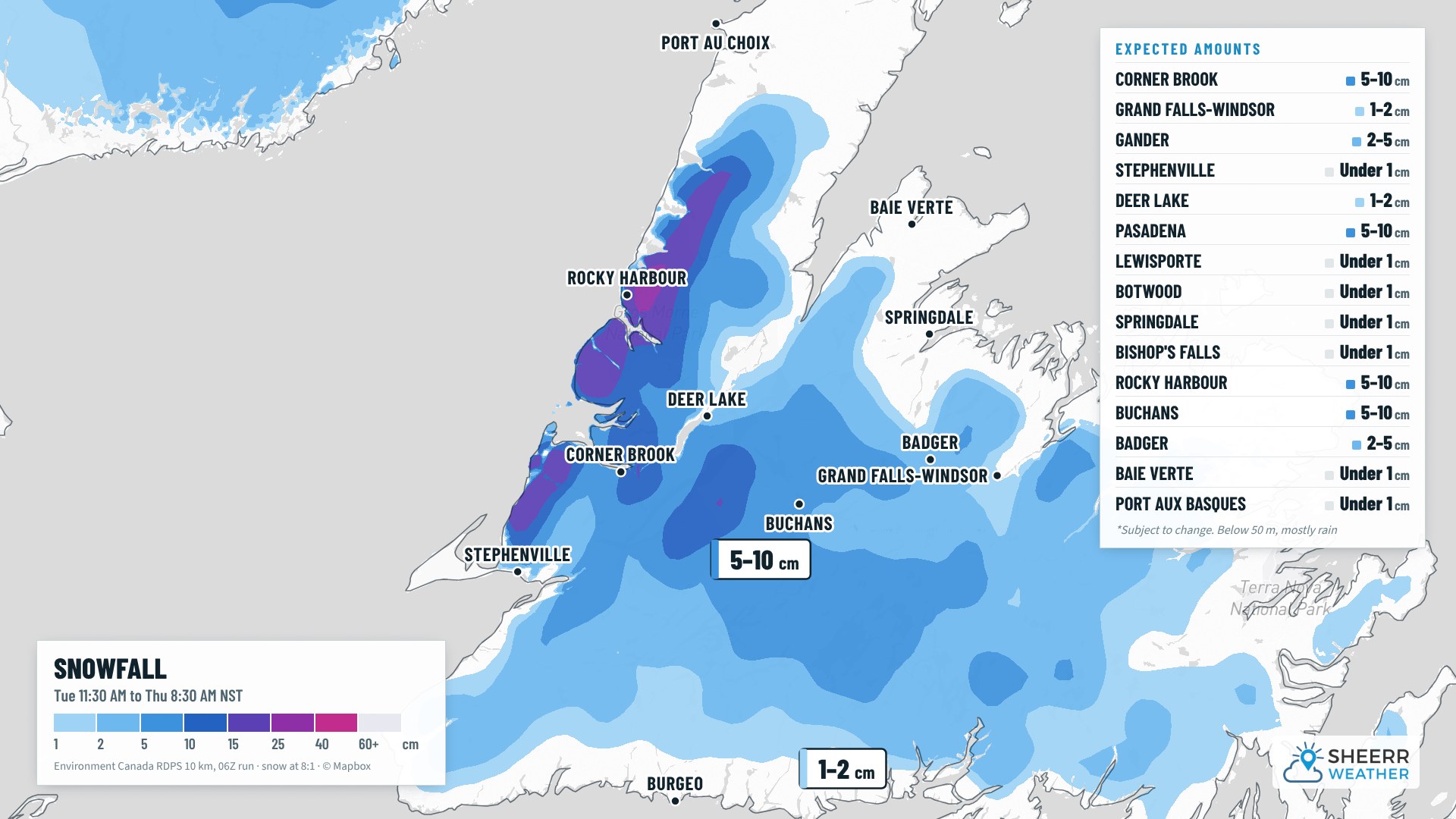
Gander is in the 2 to 5 cm range, but I’m leaning closer to 2 cm or less, and Grand Falls-Windsor 1 to 2 cm of slushy, wet snow. Corner Brook is in the 5 to 10 cm range, but that’s for the higher terrain. Down near the water, around the harbour and Humber Arm, it’s likely just rain, while up toward the Blow Me Down ski trails and the hills, like Massey Drive, will likely see the snow.
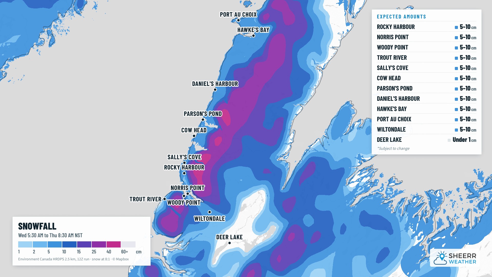
The model shows a lot of snow for Rocky Harbour, but I don’t think that’s necessarily the case. Right along the Gulf, which is still warm, it’s likely a rain or rain and snow mix with some accumulation, so I’ve put it at 5 to 10 cm. Up by the KOA it could be snowing, but as you come down the hill into Rocky Harbour and Norris Point, it’s likely rain or a sloppy mix. It’s a tricky forecast, so let me know what you see! The hilltops of the Long Range Mountains, on the other hand, may see well over 30 cm.
Environment Canada has issued a special weather statement for Gros Morne and Parson’s Pond to Hawke’s Bay. Snowfall amounts of 20 to 30 cm are possible from Wednesday morning into Thursday evening, highest over elevated terrain.
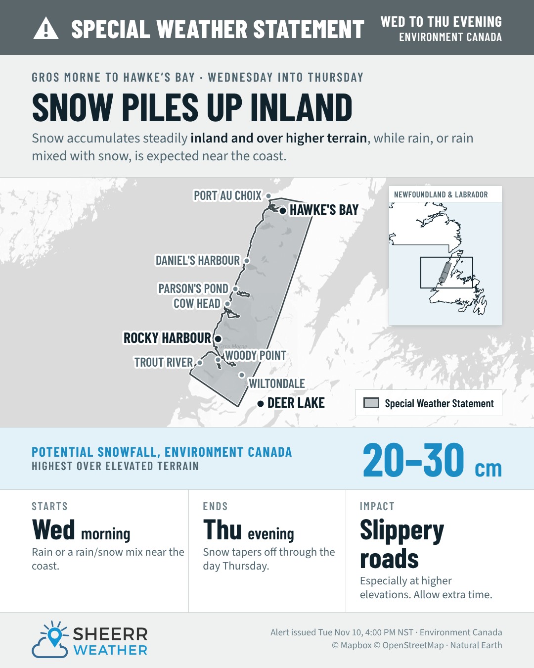
Here’s a closer look at that area using the high-resolution model. Along the coast, from Trout River up to Port au Choix, I’m going with 5 to 10 cm, since the warm Gulf will keep it a wet mix down by the water. The heavier amounts, 25 to 40 cm or more, are up over the Long Range Mountains.
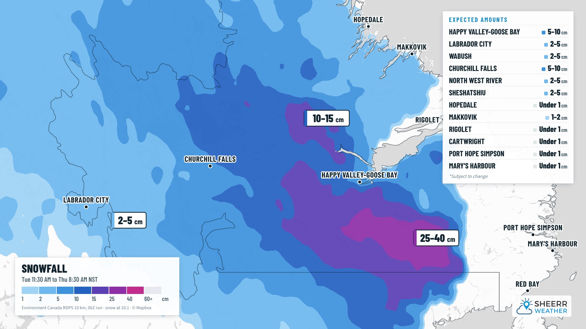
In Labrador, the Goose Bay area is looking at 5 to 10 cm of snow before a change to rain, with more in the Churchill Valley before it changes over too. The highest amounts are south of Goose Bay in the higher terrain, where it could be over 40 cm. Churchill Falls is 5 to 10 cm, with lower amounts for Labrador City and Wabush.
Wind
We’re not looking at super strong winds, but they pick up through tomorrow. Gusts reach 70 km/h on the Bonavista Peninsula by tomorrow evening. As the low pushes back toward Labrador, the southern half of the West Coast sees gusts of 50 to 70 km/h by Thursday morning, and the same for parts of the South Coast around Fortune Bay. The Avalon gusts 50 to 60 km/h Thursday morning. Winds ease through Thursday as the low weakens and fills.
Temperatures and the week ahead
Tonight drops to -7° in Churchill Falls and Labrador City. On the Island, temperatures hold at 2° to 5° as the rain moves in. Tomorrow is mild-ish across Newfoundland with the rain and wet snow, and it’ll depend on how heavy the precipitation is and how low the snow level gets in the second half of the day. For your Remembrance Day ceremonies, though, it’s more wet than anything else.
For eastern, central and western Newfoundland and the Northern Peninsula, there’s no cold air in sight, just seasonable highs of 3° to 6° pretty well across the board, with some rain and snow showers here and there after tomorrow.
In Labrador, the south sees rain and showers through Friday, maybe some rain and snow Sunday, and flurries Monday on the north coast. In the west, it cools to 1° Friday, -1° Saturday and -2° Sunday, a bit cooler Monday and Tuesday, but dry. In Goose Bay, the rain goes to snow Wednesday after some accumulation, Thursday and Friday look showery, more rain and snow showers Saturday, cloudy Sunday, and partly to mostly cloudy and a touch cooler Monday and Tuesday.
Have a good Tuesday evening, and I’ll see you tomorrow morning!
Don’t forget to…
📱 Get the Sheerr Weather App in the Apple App Store and Google Play Store for my latest updates.
📺 Tune into Sheerr Weather 24, my 24-hour weather channel on YouTube.
🗺️ Check out the Map Room to see all the latest weather observations for the Province.
🎥 Check out the Provincial Highway Cams to see 👀 what’s going on around our highways.