
Thursday Morning’s Weather Briefing — October 8, 2026
Good Thursday Morning!
Sunny and mild on the Island today, with highs in the mid-to-upper teens.
Cool and cloudy in Labrador (single digits), with areas of showers and high-elevation flurries.
Turns breezy as another low rolls in from the west.
Showers and rain return to Newfoundland tonight and Friday ahead of a cold front.
This morning’s update is sponsored by Roebothan, McKay, Marshall.
Visit MakeTheCall.ca today to learn more about how the law firm can help you!
Today is the nice part of a two-part setup. Southerly winds are pulling mild air over the Island, so you’ll see some sunshine mixed with cloud and highs mostly in the mid-teens. It’ll be breezy, though, especially in the southwest, where gusts could reach 60 km/h this afternoon. Labrador is the cold spot at 0 to 3 degrees this morning, and temps are only climbing a few degrees this afternoon, with showers around.
Then the other shoe drops tonight. A front pushes in from the west with rain, and the wind picks up along the south and west coasts, with gusts around 60 km/h. In the Wreckhouse area, it could gust as high as 80 early this evening. The heaviest rain looks to be around Gros Morne, with 10 to 20 mm and locally up to 30. Rain moves across Central/Eastern and the Avalon Friday morning and ends in the afternoon.
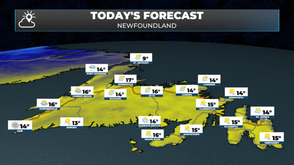
Eastern Newfoundland and the Avalon: Sunny to partly cloudy today, highs 14 to 16, warmest inland. Showers tonight, then rain Friday morning, ending in the afternoon, with highs 14 to 18. Warmest in St. John’s and inland, coolest right on the water.
Central: Sun and cloud, highs 14 to 16. A 40% chance of showers tonight with gusty south winds, up to 70 along some coasts. Rain ends Friday, highs 15 to 17.
West Coast: A few early showers, then sun and cloud, highs 13 to 16, cooler in the Long Range highlands. Rain tonight, 5 to 10 mm, 10 to 20 in the Gros Morne area. Friday is cloudy with a 60% chance of showers, highs 12 to 15.
South Coast: Sunny and cloudy, highs 13 to 15, gusty south winds. Drizzle and rain tonight, with gusts to 60 around Burgeo. Rain ends around noon Friday.
Southwest Coast: Windy today with highs 13 to 15. Showers and rain tonight, with gusts to 80 in the Wreckhouse. Friday is mostly sun and cloud with highs 12 to 15, though winds are still gusty from the west.
GNP and the Straits: Cloudy with showers and highs 8 to 12, slow to warm. Rain tonight, 5 to 10 mm, with gusts to 60. Friday is a mix of sun and cloud, highs 10 to 13.
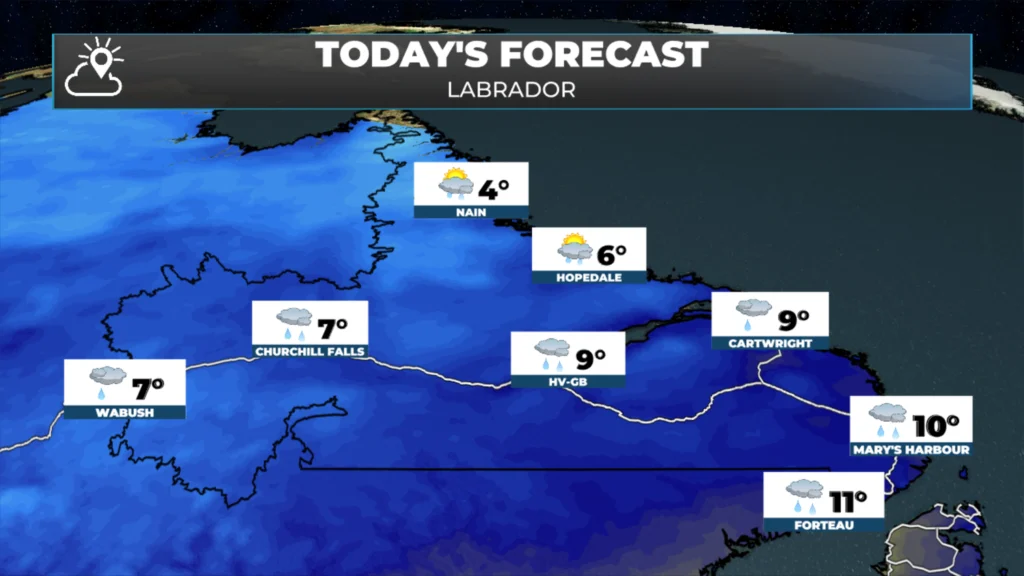
Labrador: Cool and cloudy. Lab West is 6 to 8 with showers today. Goose Bay is 8 to 10 and rainy. The North Coast is just 3 to 5 with an afternoon shower, then some snow showers early Friday. Friday highs 4 to 9.
Looking ahead, it turns noticeably colder this weekend. Highs fall to the single digits on the Island by Sunday, with showers and wind on the West Coast on Saturday. Lab West could see snow on Sunday. Another round of rain may arrive on Monday, so enjoy today’s mild air.
📱 Get the Sheerr Weather App in the Apple App Store and Google Play Store.
🗺️ Check out the Map Room to see all the latest weather observations for the Province.
🎥 Check out the Provincial Highway Cams to see 👀 what’s going on around our highways and
Thanks, Eddie.
Good Morning Eddie!
A nice day to begin storing things that need to be put away for the winter. Thanks for update. Enjoy your day!!
Thanks for the update Eddie! Beautiful day again today ! Enjoy the rest off your day 😊