
One System Departs Saturday, Another Moves In By Sunday
This forecast is sponsored by:

Satellite imagery only tells part of today’s weather story across Newfoundland and Labrador. We see plenty of cloud and some rain showers, but what we don’t see is the cold air that’s moved into Labrador through the day.
You can see the evidence on the camera in Wabush, where Route 500 looked very wintry this afternoon. Same story in Churchill Falls, where a few centimetres of snow fell today, and farther east at Cache River it’s looking snowy as well. So far the snow hasn’t made it into Happy Valley-Goose Bay, where it was 2° at 4 PM, but it might not take much longer.
Meanwhile, temperatures across the Island are still very mild at this hour. That won’t last, as the cold air surges south.
Colder air sinks south tonight and Saturday
The cold air in Labrador works its way down across the Island between tonight and Saturday. Southeastern Newfoundland and the Avalon get it last, which means Saturday may not be so bad there, at least through much of the day.
Tonight in the Big Land, temperatures fall to around -11° in the west and close to 0° on the coast. On the Island, some rain and showers roll through in the south, mostly late overnight and early Saturday.
On Saturday, it’s generally sunny in Labrador with highs near 0°. On the Island, highs of 3° to 11° don’t look so bad, but those are early highs, especially in central and eastern areas. Temperatures fall sharply in the afternoon and evening. In St. John’s, it’s 11° at noon, down to 6° by 3 PM and 3° by 6 PM. The drop comes a little earlier the farther west you go.
Those of you on the Northern Peninsula may see a little wet snow Saturday morning. With 2° in St. Anthony at 6 AM and 3° across the Strait in Blanc-Sablon and the Forteau area, any snow likely won’t stick in the lower terrain, but over the higher terrain a couple of centimetres is possible. By midday Saturday it’s still 11° in St. John’s, but only 5° in Bonavista and 4° in Gander.
Rainfall between tonight and midday Saturday is just a few millimetres, up to 10 mm on the northwest corner of the Northern Peninsula. There’s a little more snow for parts of Labrador, but I’m not expecting much outside southeastern Labrador.
By Saturday evening, we get a bit of a reprieve, but our Maritime neighbours won’t be so lucky.
Rain and wind Sunday, snow for Labrador Sunday night into Monday
Sunday is not looking like the nicest of days: chilly and rainy on the Island. In Labrador, the weather isn’t so bad through much of Sunday, but Sunday night into Monday could be a different story.
We’re watching an area of low pressure that first brings very heavy rain to the Maritimes on Saturday, raining very heavily just east of Halifax by Saturday evening. That rain reaches Newfoundland Saturday night, likely with strong Wreckhouse winds. It might even start as a little freezing rain or snow for parts of Newfoundland very early Sunday morning. Through Sunday, the low moves north and the rain becomes more widespread across much of Newfoundland.
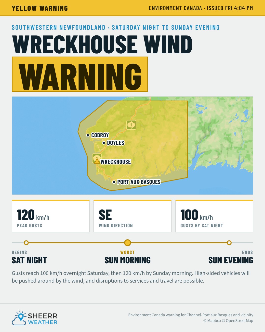
Environment Canada has issued a Wreckhouse wind warning for Channel-Port aux Basques and vicinity: southeasterly gusts of 120 km/h in the Wreckhouse area, overnight Saturday night until Sunday evening. Gusts increase to 100 km/h overnight Saturday before increasing to 120 km/h by Sunday morning. High-sided vehicles will be pushed around by the wind, and disruptions to services and travel are possible. Keep an eye on the Wreckhouse Wind Gauge on my website.
In Labrador, snow moves in by Sunday evening. In most areas outside the west, it changes to rain by Monday afternoon. Things improve slowly into Tuesday.
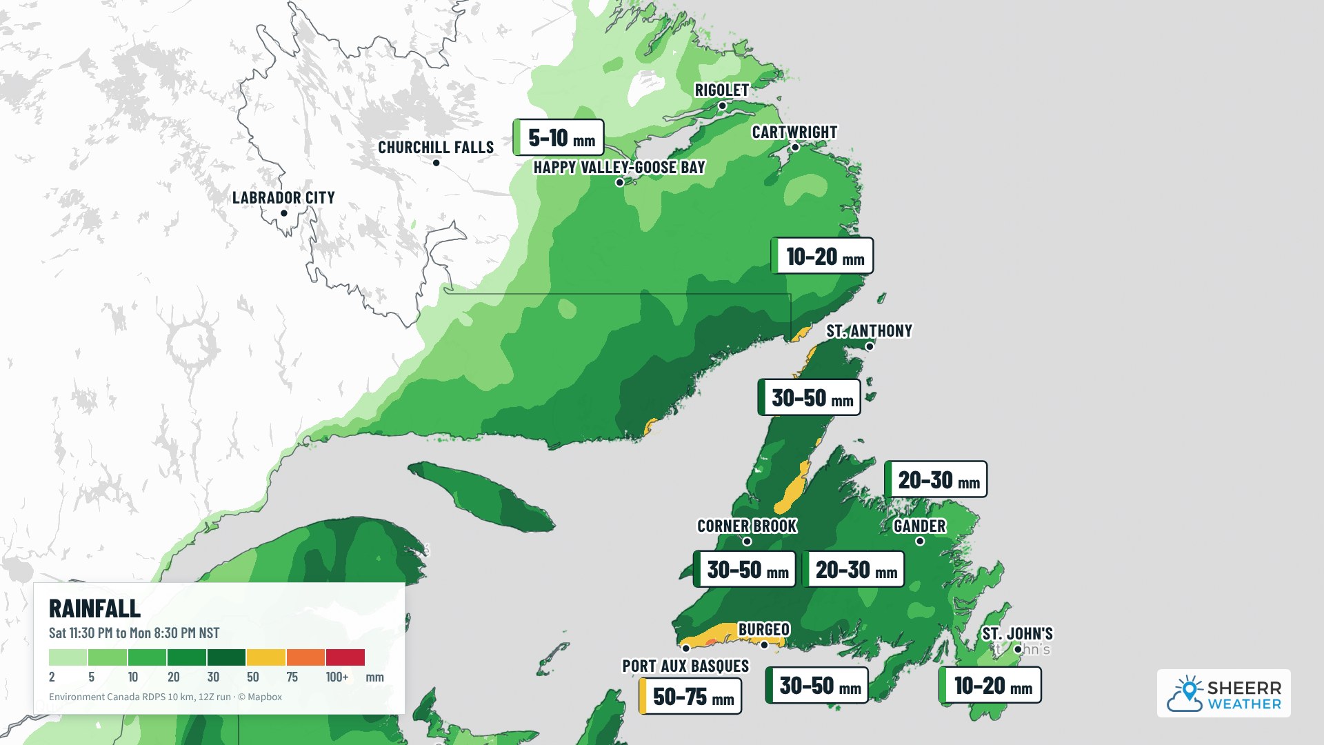
Rainfall from late Saturday through late Monday:
- Southern Newfoundland: 50 to 75 mm
- Northern Peninsula: 30 to 50 mm
- In between, central Newfoundland: about 20 to 30 mm
- Eastern Newfoundland: 10 to 20 mm
- Southeastern Labrador and the Straits: about 10 to 20 mm, with lesser amounts farther north and west
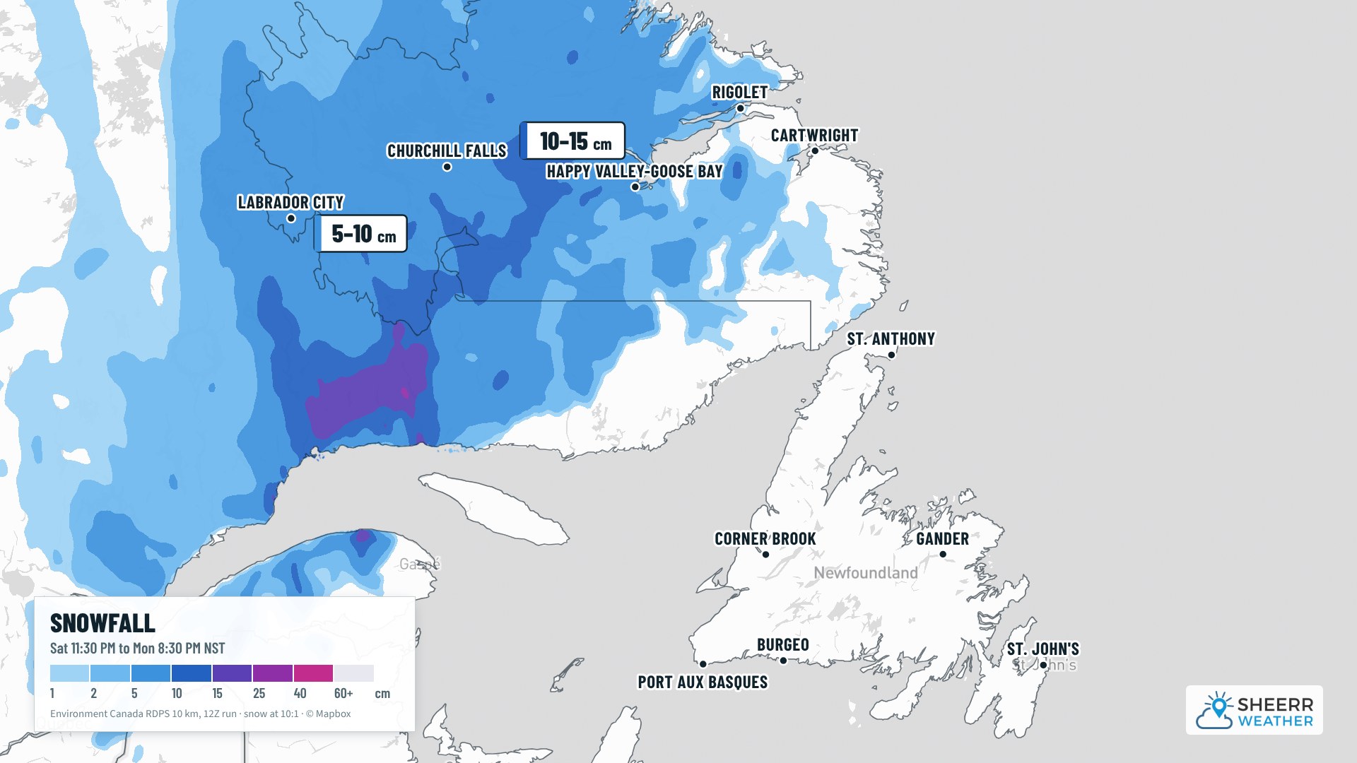
Snowfall in Labrador from late Sunday through Monday:
- Goose Bay area: 5 to 15 cm before the changeover to rain
- Labrador West: 5 to 15 cm, with more over the higher terrain
I’ll have an update on this over the weekend for sure.
Looking ahead
Once we get through Monday and Tuesday, the weather gets marginally better, but the showers stick around. Temperatures don’t fall much. After Tuesday, there may be some rain showers mixed with snow or flurries in western Newfoundland, but it’s not looking overly cold.
In Labrador, snow arrives in the west and north on Monday, with flurries lingering into the middle and later part of next week, especially in the west. For northern and southern Labrador, including the Goose Bay area, it’s not going to be overly cold, at least not just yet.
Have a very good Friday evening! I’ll see you over the weekend with an update, and as I post them, you’ll find them first in the app.
Don’t forget to…
📱 Get the Sheerr Weather App in the Apple App Store and Google Play Store for my latest updates.
📺 Tune into Sheerr Weather 24, my 24-hour weather channel on YouTube.
🗺️ Check out the Map Room to see all the latest weather observations for the Province.
🎥 Check out the Provincial Highway Cams to see 👀 what’s going on around our highways.
thanks Eddie
Welcome!