
Friday Morning’s Weather Briefing — November 6, 2026
Good Friday Morning!
- A mild start on the Island, with temperatures of 5° to 12° and the warmest air in the west: 12° in Deer Lake and 11° in Corner Brook and Stephenville.
- Labrador: rain is changing to snow this morning in Lab West and Churchill Falls, then in Goose Bay and along the coast this afternoon as temperatures fall.
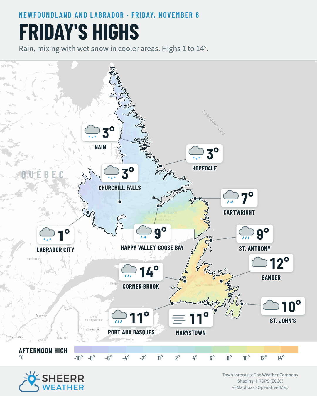
- Cloudy and mild on the Island today, with highs of 9° to 15°. Rain and showers in the west and south, and gusty southwest winds up to 50 km/h around Bonavista.
- Colder air arrives tonight. Rain mixes with snow on the Northern Peninsula, and showers move across the rest of the Island.
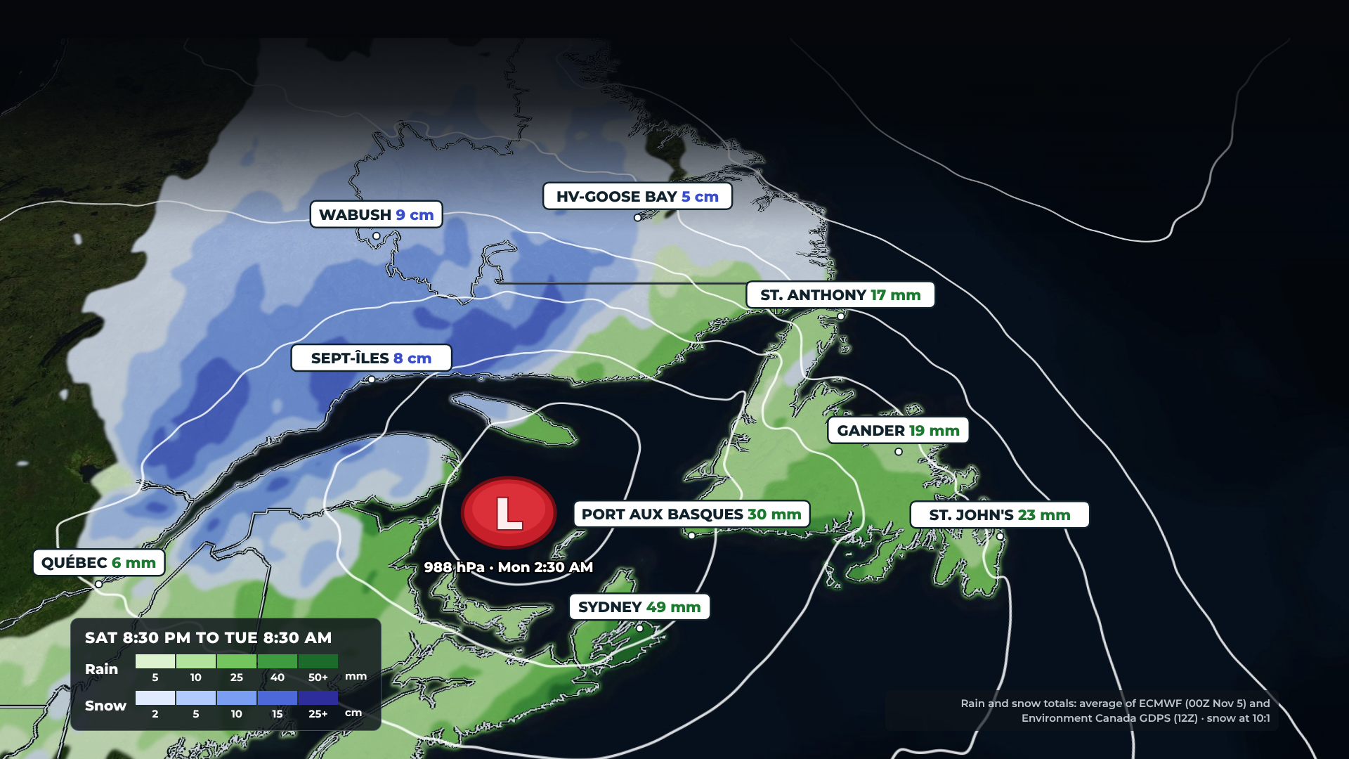
- A decent Saturday after some morning rain, then the next system brings rain, wind and possible heavy rain to the Island on Sunday, with snow for Labrador Sunday night into Monday.
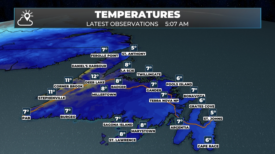
What a difference a day makes! After a frosty start yesterday, it’s a mild morning across the Island, with temperatures of 5° to 8° in the east and up to 12° in Deer Lake. Low cloud covers most of Newfoundland, and there are showers on the west coast and the Northern Peninsula.

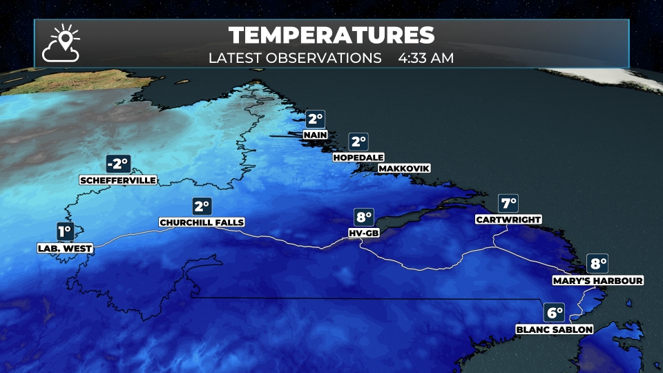
In Labrador, the change is underway. It’s down to near freezing in Lab West and 2° in Churchill Falls, Nain and Hopedale, and the rain there is changing over to snow this morning. Farther east, it’s still mild, at 8° in Goose Bay and Mary’s Harbour and 7° in Cartwright, with rain. The cold air will continue to sink south this morning, and the change to snow will follow suit.
Today, the Island stays cloudy and mild, with highs of 9° to 15°. The warmest spots are in the west, with up to 15° in Deer Lake and 14° in Corner Brook, along with periods of rain. The south coast sees showers and some fog, and the northeast coast is breezy, with southwest winds of 30 to 50 km/h around Bonavista.
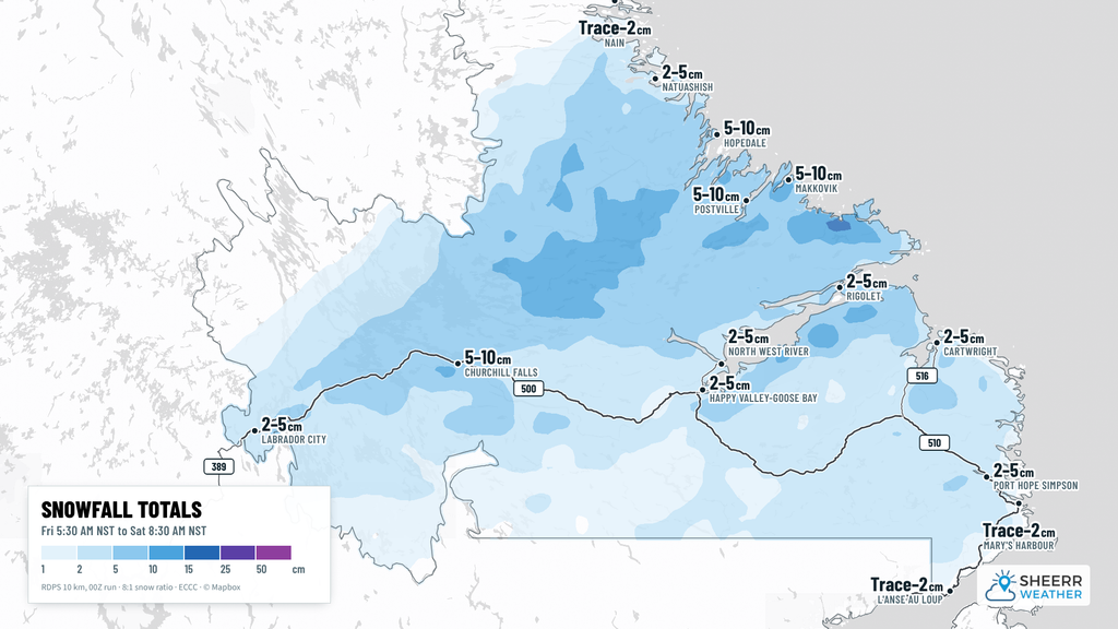
In Labrador, it’s the day of change. The snow falls in Lab West and Churchill Falls this morning, tapering to snow flurries this afternoon as temperatures drop to -4° to -6°. The rain changes to snow in Goose Bay this afternoon and along the coast later today and tonight. Makkovik and Hopedale could see 5 to 10 cm, with about 5 cm in Churchill Falls and a few centimetres in Lab City. Watch for slippery roads, especially over the higher terrain toward Churchill Falls. The drive between Churchill Falls and Labrador City will become wintry this morniung, and more of the TLH will see similar conditions as the day progresses.
Track weather and road conditions on the road cam page right here on the website. You can also find the latest road reports there from the Province of Newfoundland and Labrador.
This morning’s update is sponsored by CU Financial Management.
Visit cufm.ca to learn more, or drop by their new office at 39 Pippy Place in St. John’s!
Eastern Newfoundland / the Avalon: Overcast on the Avalon, with a slight chance of a shower, a high near 9° and south-southwest winds of 15 to 30 km/h. Showers this afternoon around Placentia and Trepassey, with highs of 9° to 10°. Cloudy and windy on the Bonavista Peninsula, with a high near 10° and southwest winds of 30 to 50 km/h. Showers tonight, with lows of 8° to 9°.
Central: Generally cloudy and mild, with a slight chance of a shower and highs of 12° to 13° in Gander and Grand Falls-Windsor. Some fog this evening, then showers after midnight, with lows of 7° to 8°.
West Coast: Rain this morning in Corner Brook, then showers this afternoon, with a high near 14°. Occasional rain showers in Deer Lake, with a high near 15°. Showers becoming a steady light rain in Stephenville, with a high near 12°. Showers tonight, with lows near 5°.
South Coast: Cloudy, with some fog and showers this afternoon, and highs of 9° to 11° around Marystown, Harbour Breton and Burgeo. Showers this evening become a steady rain overnight, with lows of 6° to 9°.
Southwest / Wreckhouse: Showers early, becoming a steady light rain this afternoon, with a high near 10° and east-southeast winds of 15 to 25 km/h. Fog and light rain tonight, with a low near 7°.
GNP and the Straits: Rain this morning in St. Anthony, then showers this afternoon, with a high near 9°. Periods of rain in Rocky Harbour, with a high near 12°. Windy with rain in Port au Choix, with a high near 10° and southwest winds of 30 to 50 km/h. Turning colder tonight, with rain mixing with snow in St. Anthony and lows of 1° to 4°.
Labrador / the Big Land: Snow this morning in Labrador City, tapering this afternoon, with 3 to 7 cm and temperatures falling to -6° to -4°. Snow changing to snow showers in Churchill Falls, with temperatures falling to -4° to -2°. Rain changing to snow in Happy Valley-Goose Bay this afternoon, with temperatures falling to 0° to 2°. Rain mixing with snow this afternoon in Cartwright. Windy with snow in Hopedale and Makkovik, with north winds of 25 to 50 km/h. Colder tonight, with lows of -11° in Lab City to -3° on the coast.
Looking ahead: Saturday starts with some rain on the Island before cooler air moves in from the north, and it looks like the nicer day of the weekend once the morning rain moves out. Then an area of low pressure from the northeastern U.S. brings rain and wind to the Island on Sunday, possibly starting with a little freezing rain in the interior west, with significant to heavy rain possible in some areas. In Labrador, snow arrives Sunday night and could be heavy at times in the west into Monday. This is still an early look, and I’ll have more details as it gets closer.
📱 Get the Sheerr Weather App in the Apple App Store and Google Play Store.
📍 Want more detail for where you live? Check out our new Regional Forecast pages for current conditions, local alerts, highway cams and the forecast for your area: Avalon · Eastern · Burin Peninsula · South Coast · West Coast · Long Range Mountains · Central · GNP & the Straits · Labrador West · Central Labrador · Labrador North Coast · Labrador South Coast
🗺️ Check out the Map Room to see all the latest weather observations for the Province.
🎥 Check out the Provincial Highway Cams to see 👀 what’s going on around our highways.
Think you for the weather
I love my cup of tea and bagel 🥯