
Wednesday Morning’s Weather Briefing — November 4, 2026
Good Wednesday Morning!
- A cold, clear start across much of the province, with temperatures of -2° to -6° on the Island and down to -10° in Churchill Falls this morning.
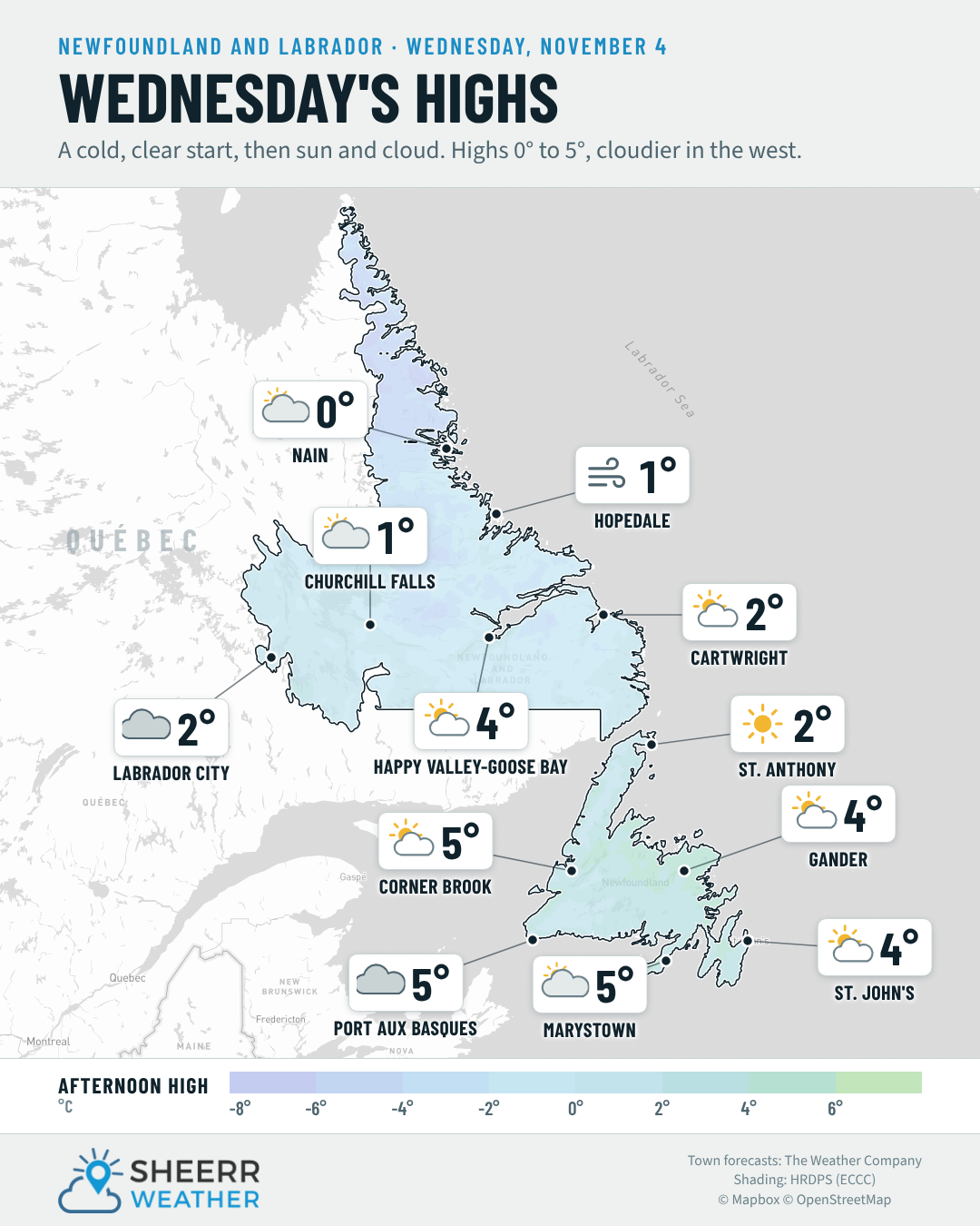
- A mix of sun and cloud today, with the most sunshine in the east and more cloud in the west. Highs of only 2° to 6° on the Island, with light winds.
- A few showers are possible around Port aux Basques and the southwest coast later today and tonight.
- Labrador: cloudy in Lab West, with highs of 0° to 4°. Rain moves into Labrador City after midnight, then spreads across the Big Land on Thursday.
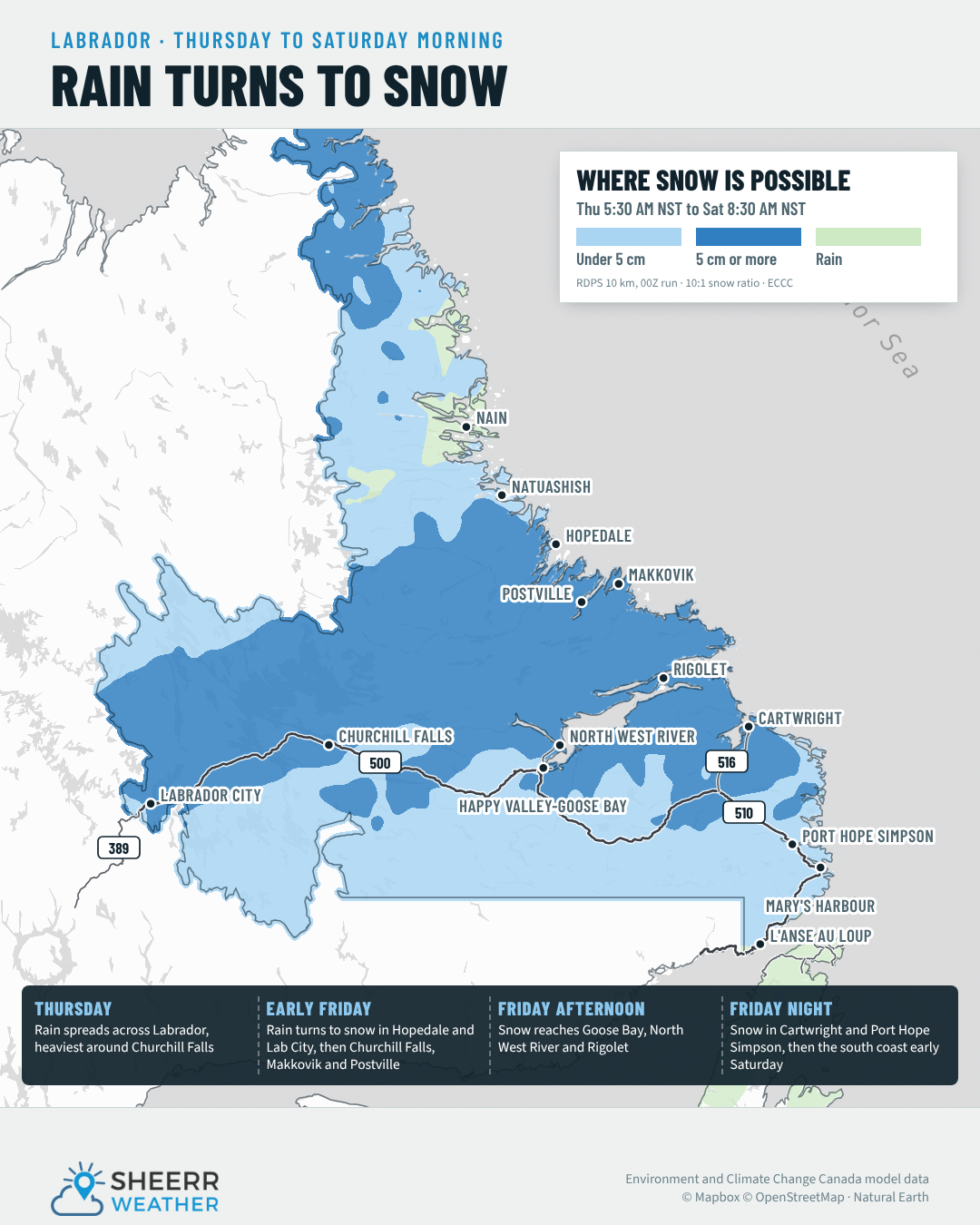
- Milder on Thursday, with highs of 6° to 9° on the Island, before rain turns to snow in parts of Labrador on Friday.
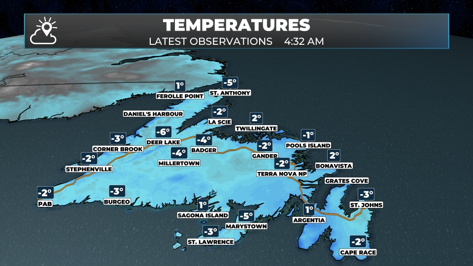
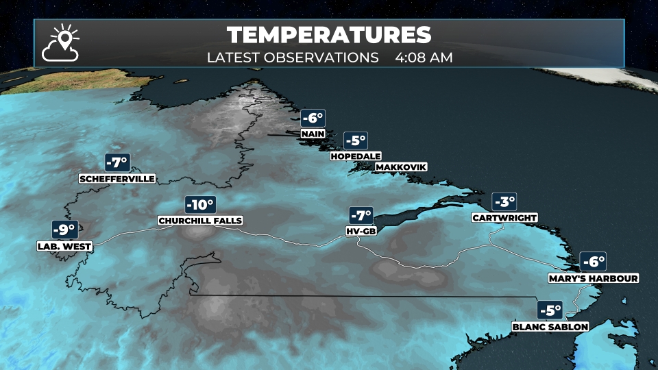
It was a cold, clear night, just as expected. Radar is quiet this morning, and satellite shows clear skies over eastern and central Newfoundland, while cloud covers much of the west coast, Lab West and central Labrador. Under those clear skies, temperatures dropped to -2° to -6° across much of the Island, with -6° in Deer Lake, and colder in Labrador, with -9° in Lab West and -10° in Churchill Falls.
| Station | Overnight low | Note |
|---|---|---|
| Churchill Falls | -14.4° | Coldest in the province |
| Wabush (Lab West) | -13.3° | |
| Deer Lake | -7.2° | Coldest on the Island |
| Goose Bay | -7.0° | |
| St. Anthony | -5.5° | |
| St. John’s (YYT) | -4.2° | Coldest since April 28 |
| Gander | -3.0° |
See the full list of overnight lows (22 stations)
| Station | Region | Low |
|---|---|---|
| Churchill Falls | Labrador | -14.4° |
| Wabush (Lab West) | Labrador | -13.3° |
| Deer Lake | West Coast | -7.2° |
| Mary’s Harbour | Labrador | -7.2° |
| Goose Bay | Labrador | -7.0° |
| Makkovik | Labrador | -7.0° |
| Nain | Labrador | -6.7° |
| St. Anthony | GNP and the Straits | -5.5° |
| Badger | Central | -5.1° |
| Hopedale | Labrador | -4.8° |
| St. Lawrence | Burin Peninsula | -4.4° |
| St. John’s (YYT) | Avalon | -4.2° |
| Burgeo | South Coast | -4.0° |
| Corner Brook | West Coast | -3.8° |
| Wreckhouse | Southwest | -3.4° |
| Stephenville | West Coast | -3.3° |
| Cartwright | Labrador | -3.2° |
| Terra Nova | Eastern | -3.2° |
| Gander | Central | -3.0° |
| Port aux Basques | Southwest | -2.2° |
| Argentia | Avalon | -0.2° |
| Bonavista | Eastern | 1.3° |
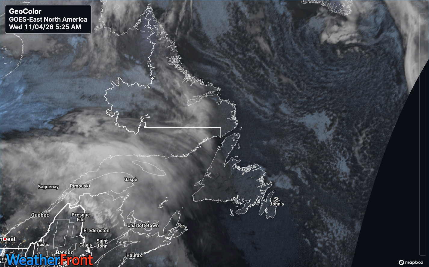
Today is another chilly one, with a mix of sun and cloud and light winds. Highs only reach 2° to 6° on the Island and 0° to 4° in Labrador. The sunniest skies are in the east, with more cloud along the west and south coasts, and a slight chance of a shower around Port aux Basques. Give yourself a few extra minutes this morning, as there could be some frost on the car.
The next system takes shape over Quebec today and brings rain to Labrador City after midnight. On Thursday, the rain spreads across Labrador, and southerly winds bring milder air to the Island, with highs of 6° to 9°.
This morning’s update is sponsored by CU Financial Management.
Visit cufm.ca to learn more, or drop by their new office at 39 Pippy Place in St. John’s!
Eastern Newfoundland / the Avalon: Partly cloudy on the Avalon, with a high near 4° and light west-northwest winds. A mix of sun and cloud around Placentia and Clarenville, with highs of 4° to 5°. West winds of 15 to 30 km/h on the Bonavista Peninsula, with a high near 4°. Clear to partly cloudy tonight, with lows of -4° to 0°.
Central: A mix of sun and cloud, with highs of 4° to 5° in Gander and Grand Falls-Windsor and light winds. Mainly clear tonight, with lows of -6° to -4°.
West Coast: Cloudy early, then partial clearing this afternoon in Corner Brook and Deer Lake, with highs of 5° to 6°. Generally cloudy in Stephenville, with a high near 5°. Lows of -3° to 1° tonight.
South Coast: A mix of sun and cloud early, then clouding over this afternoon, with highs of 4° to 5° and light winds. Overcast in Burgeo. Lows of -2° to 2° tonight.
Southwest / Wreckhouse: Generally cloudy, with a slight chance of a shower, a high near 5° and southeast winds of 15 to 30 km/h. Overcast tonight, with a slight chance of a shower and a low near 4°.
GNP and the Straits: Partly cloudy, with highs of 2° in St. Anthony to 4° in Rocky Harbour and Port au Choix. Light winds. Lows of -1° to 1° tonight.
Labrador / the Big Land: Generally cloudy in Labrador City, with a high near 2°. Rain develops after midnight, with a low near -1°. Clouding over in Churchill Falls this afternoon, with a high near 1°. A mix of sun and cloud in Happy Valley-Goose Bay, with a high near 4°, turning overcast tonight. Partly cloudy in Cartwright, with a high near 2°, and clouding over in Nain, with a high near 0°.
Looking ahead: Thursday is milder on the Island, with highs of 6° to 9° and a chance of showers on the west coast by evening. Rain spreads across Labrador on Thursday, with 6 to 12 mm in Lab West and Churchill Falls. On Friday, colder air moves in and the rain changes to snow in parts of Labrador, possibly lingering into Saturday. I’ll have more on the timing and the snow amounts as it gets closer.
📱 Get the Sheerr Weather App in the Apple App Store and Google Play Store.
📍 Want more detail for where you live? Check out our new Regional Forecast pages for current conditions, local alerts, highway cams and the forecast for your area: Avalon · Eastern · Burin Peninsula · South Coast · West Coast · Long Range Mountains · Central · GNP & the Straits · Labrador West · Central Labrador · Labrador North Coast · Labrador South Coast
🗺️ Check out the Map Room to see all the latest weather observations for the Province.
🎥 Check out the Provincial Highway Cams to see 👀 what’s going on around our highways.