
Sunday Morning’s Weather Briefing — November 1, 2026
Good Sunday Morning!
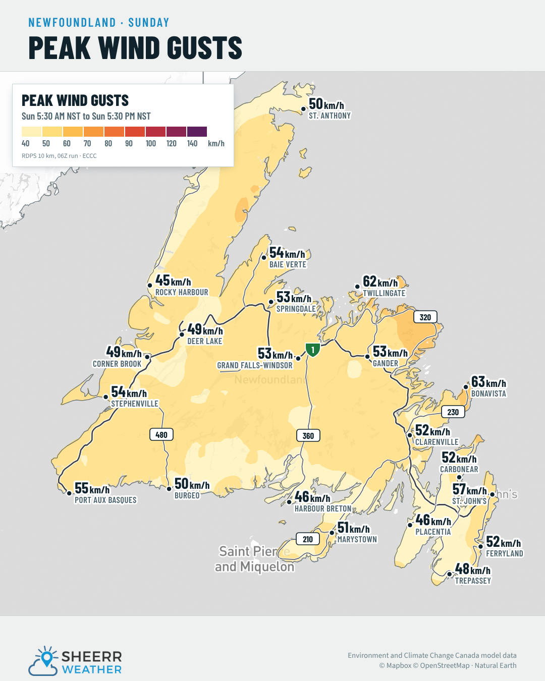
- A cold, windy start to standard time, with wind chills of -5° to -9° across the Island this morning and gusts to 70 km/h on the Bonavista Peninsula.
- A chilly Sunday, with highs of only 2° to 5°, a mix of sun and cloud in the east, and a few flurries in western and central Newfoundland.
- West-northwest winds of 25 to 50 km/h ease this afternoon and evening.
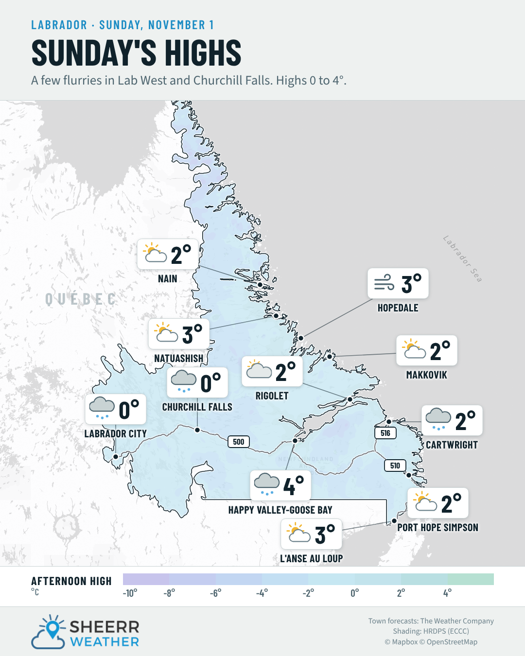
- Labrador: flurries in Lab West and Churchill Falls, highs near 0°, and windy along the North Coast tonight and Monday.
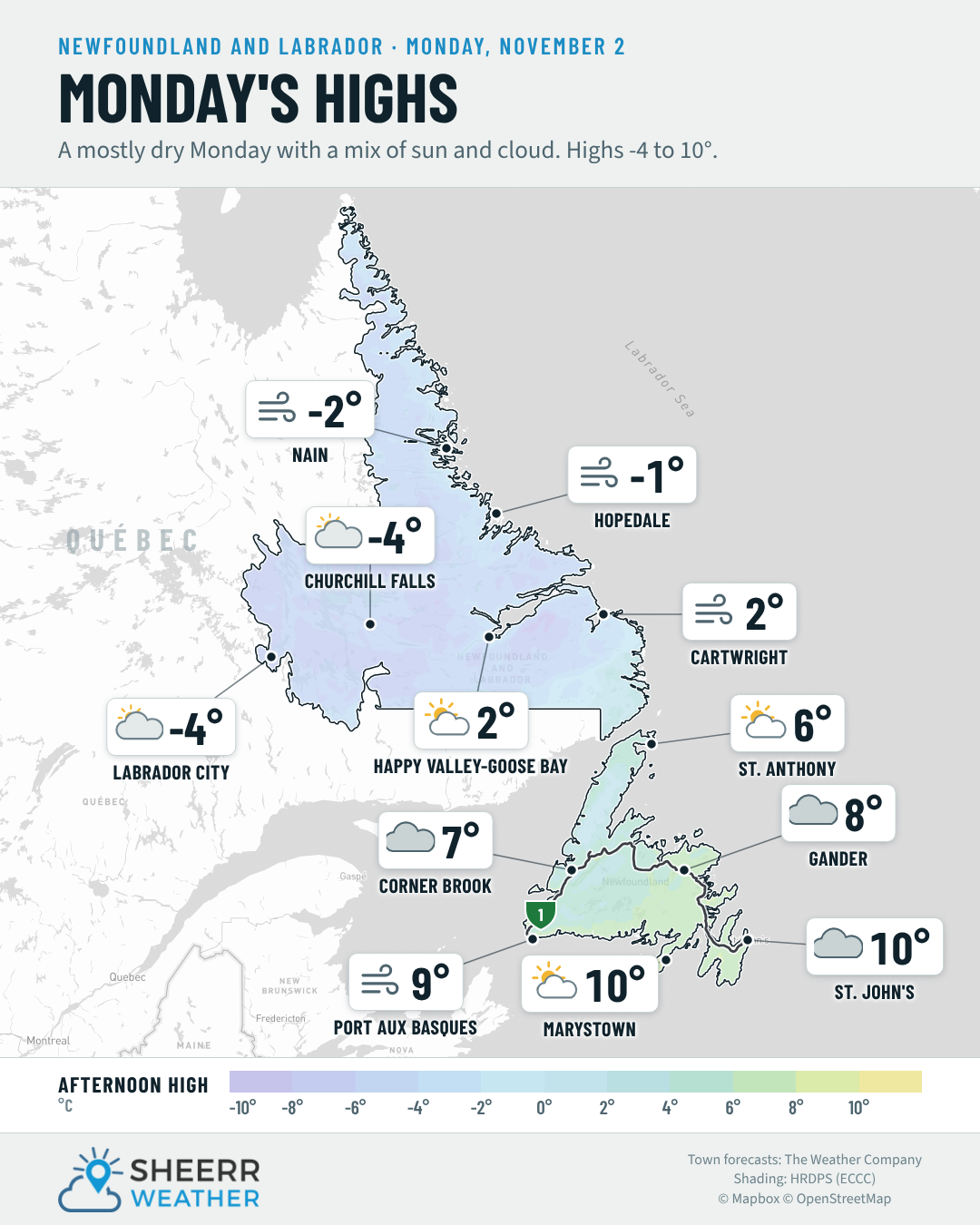
- A milder Monday, with highs of 8° to 10° on much of the Island, but windy, with southwest winds of 25 to 50 km/h.
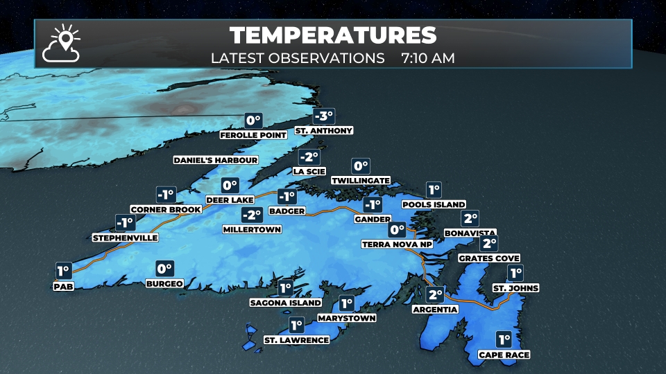
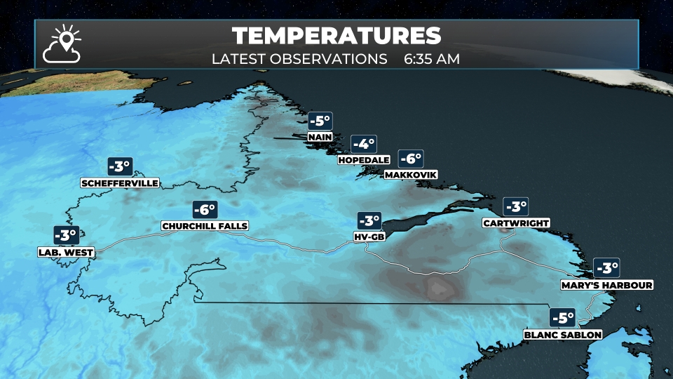
Welcome to standard time! Hopefully you enjoyed that extra hour of sleep. It’s a cold, blustery start out there. Just after 7:30 AM, it was 1° in St. John’s and Bonavista, -1° in Gander and Corner Brook, and -3° in St. Anthony. With a strong west-northwest wind, it felt like -7° in St. John’s and Corner Brook, -6° in Gander and Bonavista, and -9° in St. Anthony. Bonavista had a gust to 73 km/h. In Labrador, it was -3° in Lab West, -6° in Churchill Falls, -2° in Goose Bay and -5° in Nain.
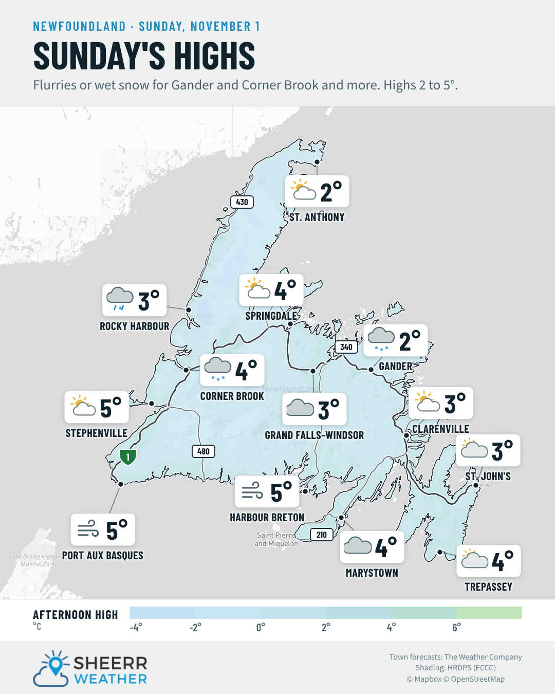
After yesterday’s rain and snow, today is cold and much quieter. Expect a mix of sun and cloud in the east and along the South Coast, with more cloud and a few flurries or snow showers in western and central Newfoundland, especially around Corner Brook, Deer Lake and the Long Range Mountains. Highs only reach 2° to 5°, and the west-northwest wind of 25 to 50 km/h will keep it feeling closer to -2° to -5° through the day, before it eases this afternoon and evening.
If you picked up some snow in central Newfoundland yesterday, it may stick around on the grass this morning, but it should mostly melt as temperatures climb above freezing.
Tonight is cloudy, with lows near or just above freezing and a few flurries or showers in the west. Then the wind turns southwest on Monday, bringing a milder day, with highs of 8° to 10° in the east and central Newfoundland, and 6° to 8° on the West Coast and the Northern Peninsula. It’ll be windy, though, with southwest winds of 25 to 50 km/h.
In Labrador, flurries and snow showers continue in Lab West and Churchill Falls today, with highs near 0°, and it turns colder Monday, with highs near -4°. Along the North Coast, the wind picks up tonight and Monday, with west winds of 40 to 55 km/h in Hopedale and Nain, and a few snow showers.
Eastern Newfoundland / the Avalon: Mostly cloudy on the Avalon, with highs of 2° to 4° and west-northwest winds 25 to 40 km/h. Partly to mostly cloudy tonight, with lows near 1°. A mix of sun and cloud around Clarenville and Terra Nova, with highs near 2° to 3°, and windy on the Bonavista Peninsula, with west-northwest winds 30 to 50 km/h. A few flurries possible tonight, with lows near 0°.
Central: A few snow showers this morning around Gander, then partly to mostly cloudy, with highs of 2° to 4°. West-northwest winds 15 to 40 km/h, strongest around Gander. A few flurries tonight, with lows near -1° to 0°.
West Coast: Flurries and a few snow showers today around Corner Brook and Deer Lake, with highs of 3° to 5°. West winds 15 to 30 km/h. Cloudy tonight, with a chance of a rain or wet snow shower, and lows of 1° to 4°. Snow showers over the Long Range Mountains, with 2 to 3 cm possible in the Gros Morne highlands tonight.
South Coast: Windy with a mix of sun and cloud this morning on the Burin and the Connaigre Peninsula, with west-northwest winds 30 to 50 km/h, then cloudier this afternoon. Highs of 3° to 5°. A slight chance of a shower tonight, with lows of 0° to 3°.
Southwest / PAB: Cloudy and becoming windy, with a high near 5° in Port aux Basques and a chance of a rain or wet snow shower. West-northwest winds 30 to 50 km/h, staying gusty tonight, with a low near 4°. Westerly winds don’t usually cause trouble at Wreckhouse, but you can always check the Wreckhouse Wind Gauge before you travel.
GNP and the Straits: Partly cloudy, with highs of 2° to 3° and west winds 25 to 40 km/h. Becoming cloudy and windy tonight, with southwest winds 30 to 50 km/h and a few showers on the southern part of the peninsula. Lows of 0° to 3°.
Labrador / the Big Land: Flurries and snow showers in Lab West today, with a high near 0°, and a few snow showers developing this afternoon in Churchill Falls. Lows near -6° tonight. A few snow showers this morning in Goose Bay, then partly to mostly cloudy, with a high near 4°. Partly cloudy along the North Coast and southeast coast, with highs of 2° to 3°, then windy tonight on the North Coast, with west-southwest winds 30 to 55 km/h. Lows of -5° to -1°.
Looking ahead: Monday is milder and windy, with highs near 8° to 10°. Temperatures stay seasonable through midweek, with no major weather on the horizon for now.
📱 Get the Sheerr Weather App in the Apple App Store and Google Play Store.
📍 Want more detail for where you live? Check out our new Regional Forecast pages for current conditions, local alerts, highway cams and the forecast for your area: Avalon · Eastern · Burin Peninsula · South Coast · West Coast · Long Range Mountains · Central · GNP & the Straits · Labrador West · Central Labrador · Labrador North Coast · Labrador South Coast
🗺️ Check out the Map Room to see all the latest weather observations for the Province.
🎥 Check out the Provincial Highway Cams to see 👀 what’s going on around our highways.
thanks Eddie