
Graupel Falls on the Avalon as Colder Air Settles In
This forecast is sponsored by:

Earlier this afternoon, temperatures were well above freezing across parts of eastern and northeastern Newfoundland. But at the same time, some showers were working through, and some of them didn’t exactly fall like rain. A photo from Paradise taken by Heath Holmes looks an awful lot like snow, and in a video Georgina Penney took in Topsail, you can hear it bouncing off everything. Turn your sound on for this one!
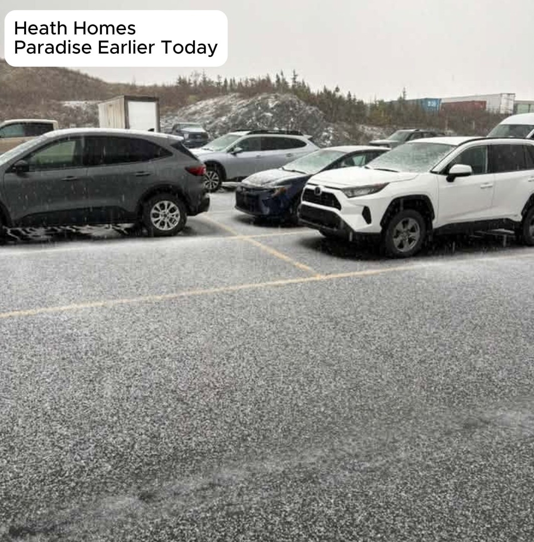
That, my friends, is graupel! We had graupel falling over the Northeast Avalon earlier today, with reports from Brigus to Topsail and even parts of St. John’s.
What is graupel? ❄️
I get this question literally every single season! Graupel is a snowflake that falls through supercooled water droplets. That water freezes onto the snowflake (we call that riming), forming a ball of ice. The snowflake loses its flake shape and turns into a soft, white, opaque pellet about 2 to 5 mm across.
It resembles hail or ice pellets, but it’s very different from both:
- Graupel starts as a snowflake. It’s soft, and it forms in cold showers or when there’s cold air aloft, which is what we had today.
- Ice pellets start as a raindrop that freezes on the way down. They’re hard and generally smaller than graupel.
- Hail only forms in thunderstorms.
A chilly night and a cold Wednesday 🥶
That cold air moved in between last night and this morning, and it’s going to really establish itself, setting us up for a very chilly night and a cold day tomorrow.
In the St. John’s metro area, it’s near 3 degrees by 6 o’clock this evening, with a wind chill near minus 2. By 6 AM tomorrow, it’s 1 degree, with winds gusting to 50 km/h and a wind chill down to minus 6. At 9 AM, we’re still at 1 degree, on our way to a high of only about 3.
Overnight, temperatures dip into the single digits, near or below the freezing mark in places like Buchans and Springdale, and even St. John’s falls to minus 1 tonight. Tomorrow brings a decent-ish recovery in some areas. It’ll be breezy once more, with a mix of sun and cloud to mostly sunny skies and highs of 3 to 6 degrees. Any flurries or showers become less widespread overnight, and especially by tomorrow.
Labrador
It certainly is cold in the Big Land today as well. This afternoon, it was only minus 3 in Churchill Falls and minus 4 in Schefferville at 2:10 PM, while readings along the coast are closer to the freezing mark. Tonight, temperatures won’t fall much more in the west, holding near minus 4 with some flurries here and there. Tomorrow brings highs of 0 to 4 under a mix of sun and cloud, with a few more clouds than anything else in Lab West, but overall the weather stays fairly quiet.
Quiet until Friday
Futurecast paints that picture nicely. By midnight, just a few flurries are left in the Long Range Mountains, a few scattered flurries in Labrador tomorrow morning, and maybe a few brushing the Bonavista Peninsula around Bonavista Bay as we start our Wednesday. Through the day on Wednesday, it’s very quiet across Newfoundland and Labrador, with just different amounts of cloud cover, and that stays with us into Thursday.
By Friday, things change a bit and we moderate significantly: 12 degrees for the high in eastern Newfoundland, low teens for central, and 10 for the West and Southwest coasts, but rain arrives in those western areas late in the day. In Labrador, we warm up a little too, especially on the coast, as we close out the work week.
Your Halloween forecast 🎃
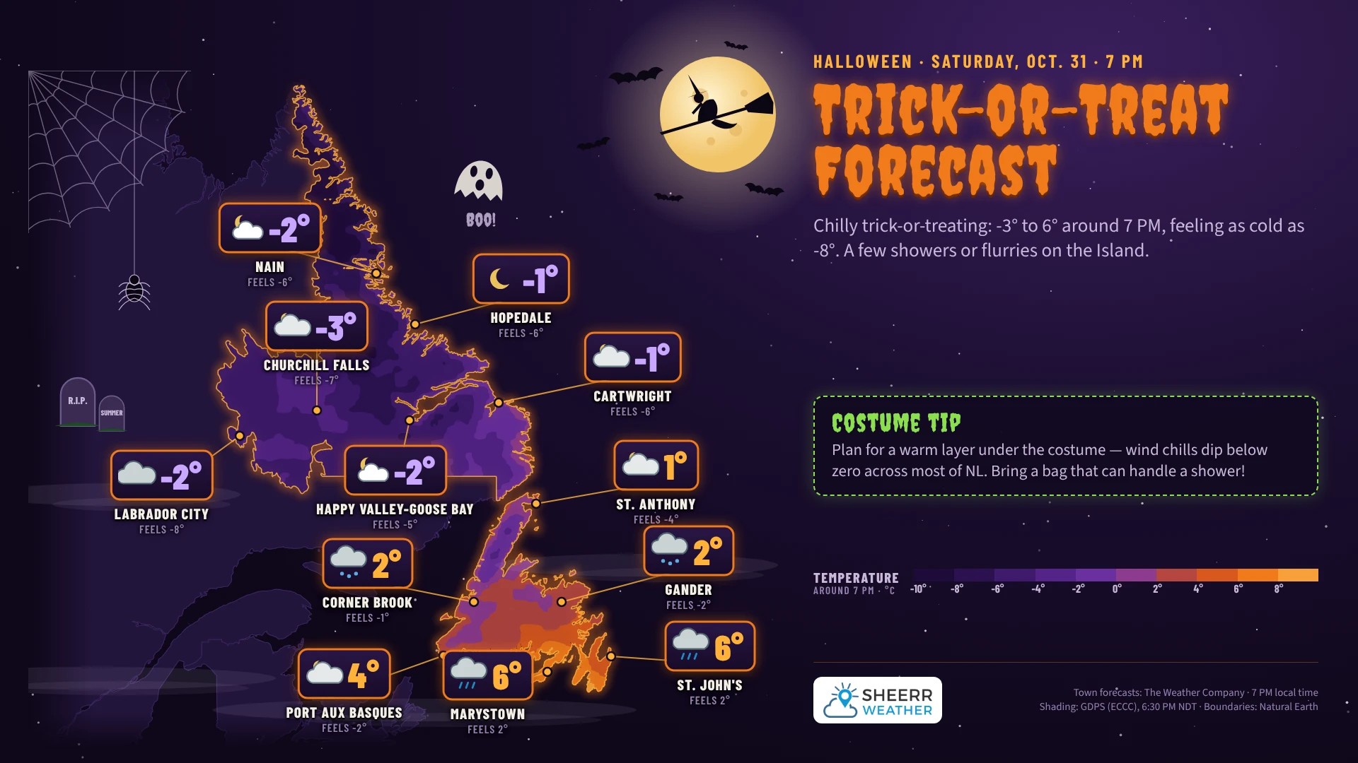
Unfortunately, the weekend, particularly Saturday, is looking a little chilly. An area of low pressure passes through southern Labrador or over the Northern Peninsula on Friday, bringing a little rain and snow to parts of Labrador, though it’s short-lived. It also drags a cold front across Newfoundland during the day Friday as the low tracks into the North Atlantic, setting the stage for a cool-ish Halloween, with a few flurries or showers here and there. But overall, it’s not looking too bad, and we’re not looking at a major storm by any stretch of the imagination.
For the trick-or-treaters on Saturday evening around 7 PM, it looks like 2 degrees in Corner Brook with some showers or flurries, 1 degree and dry in St. Anthony, and 6 degrees in St. John’s. A few passing showers are possible, but at the moment I wouldn’t bank on rain. Labrador looks dry and cold, cold being the operative word, with temperatures of minus 1 to minus 3 feeling as cold as minus 8!
So it could be a Halloween where the kids are heading out in their snowsuits, or at least in layers, with their costumes on top. A marshmallow costume, or the Stay Puft Marshmallow Man from Ghostbusters, might be a good choice to keep warm, since a snowsuit underneath won’t make much difference to that costume! 👻
Looking ahead
The 7-day forecast for eastern, central and western Newfoundland and the Northern Peninsula cools down a little by the weekend after warming up to close out the week, but there are no major weather systems in play for the time being. In Labrador, temperatures are around 4 or 5 in the south, and in the north, the west and the Goose Bay area, a couple of days above freezing and a couple near freezing. Overall, nothing major in the forecast as we head into early November.
Don’t forget: our clocks fall back one hour at 2 AM Sunday morning as we go back to standard time. That will bring us some briefly lighter mornings, but we’re still losing daylight heading toward the winter solstice, so after a couple of weeks the mornings will be just as dark as they are now.
Have a very good Tuesday evening, and I’ll see you bright and early tomorrow morning!
Don’t forget to…
📱 Get the Sheerr Weather App in the Apple App Store and Google Play Store for my latest updates.
📺 Tune into Sheerr Weather 24, my 24-hour weather channel on YouTube.
🗺️ Check out the Map Room to see all the latest weather observations for the Province.
🎥 Check out the Provincial Highway Cams to see 👀 what’s going on around our highways.