
Potent Storm Expected Tuesday into Wednesday; Special Weather Statement Issued
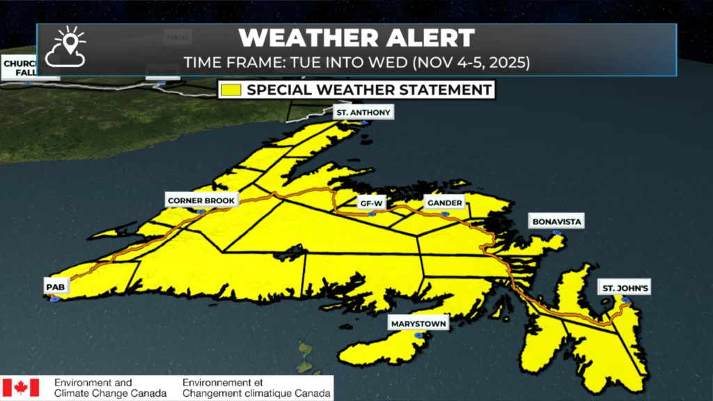
The Environment and Climate Change Canada Weather Office in Gander has issued a Special Weather Statement for Newfoundland as a rapidly deepening low-pressure system is expected to move toward the Island beginning midday Tuesday, lasting through Wednesday evening.
Potential Hazards
Significant rainfall exceeding 50 mm in 24 hours
Strong winds possibly exceeding 100 km/h
Coastal Flooding from storm surge and large waves
Discussion
According to the Special Weather Statement, the low-pressure system will rapidly intensify as it approaches Newfoundland from the south on Tuesday. Forecast confidence with this system remains low, as computer models have shown poor agreement on both the track and strength of the storm as it crosses the Island.
Some forecast solutions also suggest snow may develop in inland areas, although any accumulation is uncertain at this time.
Historical Context
Similar systems in the past have led to:
Minor flooding and hazardous travel due to heavy rainfall
Minor damage and utility outages from strong winds
Coastal flooding and damage to shoreline infrastructure
Stay Tuned
The ECCC NL Weather Office in Gander notes that further details will be added as the scenario becomes clearer.
Sheerr Weather will continue to monitor this system closely and provide updates as new information becomes available. Be sure to get the Sheerr Weather App to get Eddie’s latest forecasts and the most up-to-date alerts from Environment and Climate Change Canada.
ALERT UPDATE: 7:25 PM
The following areas of Labrador are also under a Special Weather Statement:
Re Bay to L’anse-au-Clair
Norman Bay to Lodge Bay
Cartwright to Black Tickle
Rigolet and vicinity
Postville – Makkovik
Hopedale and vicinity
Nain and vicinity
A deep low-pressure system is expected to affect Labrador beginning Tuesday night, with impacts potentially lasting until Friday night.
What to Expect
Heavy Rain: Up to 50 mm in 24 hours, especially along coastal areas.
Strong Winds: Gusts may reach 100 km/h, particularly over southeastern Labrador.
Coastal Flooding: Large waves and a possible storm surge could lead to localized flooding along the coast.
Timing and Track
The low will first cross Newfoundland on Tuesday, then stall over the Atlantic for a day or two before tracking back toward Labrador later in the week. As it loops northward, widespread rain will develop along the coast, while snowfall is likely inland and over higher terrain. The mix of heavy rain, snow, and wind will make for challenging travel conditions at times.
Potential Impacts
Residents along the coast should prepare for:
Poor driving conditions due to rain and snow
Minor coastal flooding and potential damage to shoreline infrastructure
Periods of reduced visibility in wind-driven rain and blowing snow
Outlook
This setup has similarities to previous storms that produced flooding, erosion, and brief power outages across coastal Labrador.
Environment and Climate Change Canada says the exact track and intensity remain uncertain — updates will follow as the forecast becomes clearer later this week.
Thanks for keeping us informed Eddie
Thank you
Thank you Eddie for a reliable forecast!
Thanks Eddie, have a great day
I seen heavy snow thrusday for gander
Thanks Eddie! You are a great meteorologist with a big heart for this Province!
Thanks for weather update Eddie
Thanks Eddie for the heads up have a great Sunday 👍👍
Thanks Eddie.You do a great job.It’s great having the Sheer Weather App.
Thanks for the heads up! 👍👍
Thanks again and again, love your app.
Got your app looks good
Thanks Eddie
Thanks Eddie for the update
Thanks Eddie for update!