
Winter Storm Warning(s) Issued By Environment Canada Ahead Of The Incoming Winter Storm
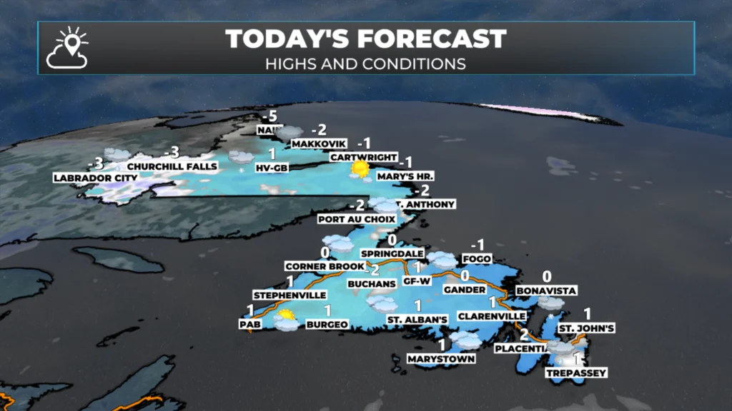
NL’s forecast for today, February 17, 2026
Good Tuesday morning
Here are today’s weather highlights:
The weather across NL today will be quiet ahead of our incoming winter storm. Snow will not arrive over the southern areas of the Avalon until late this afternoon or evening. Snow will spread north and west overnight and on Wednesday
Highs today will be near 0º on the Island and well below in Labrador.
Ahead of the incoming winter storm, Environment Canada has issued Yellow and Orange Level Winter Storm Warnings for the Avalon Peninsula and northeastern Newfoundland. Special Weather Statements extend as far west as Green Bay-White Bay.
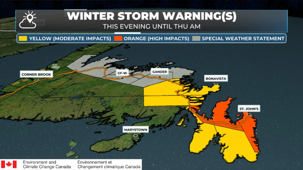
Winter Storm Alerts as of February 17, 2026 at 6 AM NST.
WEATHER ALERT RUNDOWN (ENVIRONMENT CANADA ISSUES THESE ALERTS)
An Orange Level Winter Storm Warning is in effect from this evening until late Wednesday or early Thursday morning for the following areas:
Avalon Peninsula North
St. John’s and vicinity
Expected Snowfall: 25 to 50 cm —> Locations inland over higher terrain have the best chance of seeing the upper range of the forecast, while the lower end of the range is more likely at lower elevations along the coast.
Snowfall rates will be 2 to 5 cm per hour at times, and maximum wind gusts will be as high as 80 km/h over exposed areas (from the north). The combination of heavy snowfall and high winds will create reduced visibility at times, especially late tonight into Wednesday morning.
While the heaviest snow is expected to taper off Wednesday night, periods of snow, freezing drizzle or drizzle will continue into the weekend, resulting in additional snowfall accumulations.
A Yellow Level Winter Storm Warning is in effect for the following areas from this evening until Wednesday morning.
Avalon Peninsula Southeast
Avalon Peninsula Southeast
Expected Snowfall: 15 to 30 cm —> Locations inland over higher terrain have the best chance of seeing the upper range of the forecast, while the lower end of the range is more likely at lower elevations along the coast.
Snowfall rates will be 2 to 5 cm per hour at times, and maximum wind gusts will be as high as 100 km/h over exposed areas (from the north). The combination of heavy snowfall and high winds will create reduced visibility at times, especially late tonight into Wednesday morning.
The snow will become more intermittent on Wednesday morning and likely mix with rain along parts of the coast.
A Yellow Level Winter Storm Warning is in effect for the following areas from tonight until Wednesday night or early Thursday morning:
Bonavista Peninsula
Clarenville and vicinity
Terra Nova
Expected Snowfall: 25 to 35 cm —> Locations inland over higher terrain have the best chance of seeing the upper range of the forecast, while the lower end of the range is more likely at lower elevations along the coast.
Snowfall rates will be 2 to 5 cm per hour at times, and maximum wind gusts will be as high as 70 km/h over exposed areas (from the north). The combination of heavy snowfall and high winds will create reduced visibility at times, especially late tonight into Wednesday morning.
While the heaviest snow is expected to taper off Wednesday night, periods of snow, freezing drizzle or drizzle will continue into the weekend, resulting in additional snowfall accumulations.
A Special Weather Statement is in effect for the following areas for the early Wednesday morning until this weekend time frame:
Grand Falls-Windsor and vicinity
Bay of Exploits
Bonavista North
Gander and vicinity
Green Bay – White Bay
Potential snowfall: 15 to 25 cm through Thursday morning with additional amounts likely in subsequent periods of snowfall afterwards. The highest snowfall amounts will be inland and over higher terrain, with lesser amounts at lower elevations along the coast.
Potential wind gusts: northerly 50 to 70 km/h.
Strong winds accompanying the snow will reduce visibility in blowing snow, especially over exposed areas, on Wednesday.
While the original round of heavier snow is expected to taper off by Thursday morning, more periods of snow, along with periods of freezing drizzle or drizzle will follow, and continue into the weekend, resulting in additional snowfall accumulations.
More details and possible warnings will follow in subsequent forecasts.
Please note that my forecast charts and maps may differ from Environment Canada’s at times.
I would like you to know the EC office in Gander is staffed with some of the best meteorologists in NL. They work tirelessly to keep the public informed about incoming weather events. I respect them greatly and appreciate the work they do for our Province.
I’ll have updates for you throughout the day!
📱 Get the Sheerr Weather App in the Apple App Store and Google Play Store.
🗺️ Check out the Map Room to see all the latest weather observations for the Province.
🎥 Check out the Provincial Highway Cams to see 👀 what’s going on around our highways and
Good morning
Thanks for the update
Hopefully we won’t get as much as predicted 🙏
Thank you to you and the EC office Eddie! I have respect for the work all of you do.
Thanks for the update Eddie, it’s very calm in Pouch Cove this morning, the calm before the storm.
Thanks Eddie. I’m guessing the gas stations will be busy today, as will WalMart n Dollarama as people stock up on storm chips and such. Stay safe everyone.
Thanks for the update Eddie! It is what it is 😊🌬️❄️🌬️❄️
Enjoy your day….
Good morning, for weather update
So the Burin Peninsula escapes this one??
Totally missing the West Coast, you gotta love it!
Thanks Eddie for the detailed forecast..
Thank you Eddy for your update
Thanks Eddie for everything you do to keep us informed
Thank you for the update and the shout out to our local meteorologists .
Thanks Eddie