
Alerts
All alerts →
Across NL
St. John's13°Cloudy/WindWSW 32G56Carbonear13°Cloudy/WindWSW 34G56Clarenville11°CloudyWSW 23G40Marystown13°Showers NearWSW 35G58Gander7°Rain ShowerNW 11Grand Falls-Windsor7°Rain ShowerN 10Deer Lake3°RainNNE 16G27Corner Brook6°Rain ShowerNW 14G27Stephenville7°RainN 13Port aux Basques11°Cloudy/WindW 35G53St. Anthony3°CloudyN 19G32Goose Bay2°M CloudyNW 29G50Labrador City-2°M CloudyNNW 21G35Nain1°P Cldy/WindWNW 51G80
● Watch Live

Home  /  Alerts

Active Weather Alerts

Newfoundland & Labrador · live from Environment Canada

Last updated: Mon, Oct 12, 12:32 PM NDT · refreshes every 10 minutes

5
Active alerts across NL: 5 statements
Green Bay - White Bay
Special weather statement
Issued: Mon, Oct 12, 11:04 AM NDT
Details
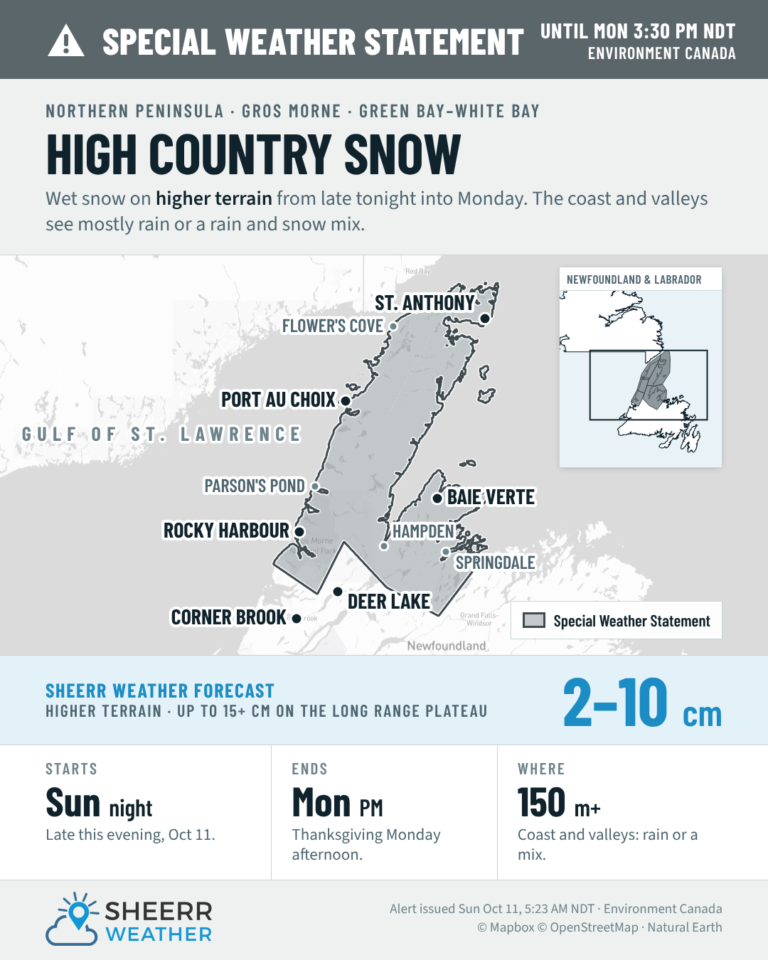
The first notable accumulating snowfall of the season is expected.

Locations: higher elevations of the Great Northern Peninsula, and Green Bay - White Bay.

Total snowfall: locally 2 to 7 cm over higher terrain. Higher amounts are possible over the high back country of the Long Range Mountains.

Time span: continuing until this afternoon.

Remarks: Coastal areas and lower elevations will see primarily rain or a rain and wet snow mix. The chance of experiencing winterlike conditions will increase with elevation as temperatures will be closer to, or even below the freezing mark.

Please continue to monitor alerts and forecasts issued by Environment Canada. To report severe weather, send an email to NLstorm@ec.gc.ca or post reports on social media using #NLwx.
Expires: Mon, Oct 12, 5:36 PM NDT
View all alerts on weather.gc.ca →
Gros Morne
Special weather statement
Issued: Mon, Oct 12, 11:04 AM NDT
Details
The first notable accumulating snowfall of the season is expected.

Locations: higher elevations of the Great Northern Peninsula, and Green Bay - White Bay.

Total snowfall: locally 2 to 7 cm over higher terrain. Higher amounts are possible over the high back country of the Long Range Mountains.

Time span: continuing until this afternoon.

Remarks: Coastal areas and lower elevations will see primarily rain or a rain and wet snow mix. The chance of experiencing winterlike conditions will increase with elevation as temperatures will be closer to, or even below the freezing mark.

Please continue to monitor alerts and forecasts issued by Environment Canada. To report severe weather, send an email to NLstorm@ec.gc.ca or post reports on social media using #NLwx.
Expires: Mon, Oct 12, 5:36 PM NDT
View all alerts on weather.gc.ca →
Northern Peninsula East
Special weather statement
Issued: Mon, Oct 12, 11:04 AM NDT
Details
The first notable accumulating snowfall of the season is expected.

Locations: higher elevations of the Great Northern Peninsula, and Green Bay - White Bay.

Total snowfall: locally 2 to 7 cm over higher terrain. Higher amounts are possible over the high back country of the Long Range Mountains.

Time span: continuing until this afternoon.

Remarks: Coastal areas and lower elevations will see primarily rain or a rain and wet snow mix. The chance of experiencing winterlike conditions will increase with elevation as temperatures will be closer to, or even below the freezing mark.

Please continue to monitor alerts and forecasts issued by Environment Canada. To report severe weather, send an email to NLstorm@ec.gc.ca or post reports on social media using #NLwx.
Expires: Mon, Oct 12, 5:36 PM NDT
View all alerts on weather.gc.ca →
Parson's Pond - Hawke's Bay
Special weather statement
Issued: Mon, Oct 12, 11:04 AM NDT
Details
The first notable accumulating snowfall of the season is expected.

Locations: higher elevations of the Great Northern Peninsula, and Green Bay - White Bay.

Total snowfall: locally 2 to 7 cm over higher terrain. Higher amounts are possible over the high back country of the Long Range Mountains.

Time span: continuing until this afternoon.

Remarks: Coastal areas and lower elevations will see primarily rain or a rain and wet snow mix. The chance of experiencing winterlike conditions will increase with elevation as temperatures will be closer to, or even below the freezing mark.

Please continue to monitor alerts and forecasts issued by Environment Canada. To report severe weather, send an email to NLstorm@ec.gc.ca or post reports on social media using #NLwx.
Expires: Mon, Oct 12, 5:36 PM NDT
View all alerts on weather.gc.ca →
Port Saunders and the Straits
Special weather statement
Issued: Mon, Oct 12, 11:04 AM NDT
Details
The first notable accumulating snowfall of the season is expected.

Locations: higher elevations of the Great Northern Peninsula, and Green Bay - White Bay.

Total snowfall: locally 2 to 7 cm over higher terrain. Higher amounts are possible over the high back country of the Long Range Mountains.

Time span: continuing until this afternoon.

Remarks: Coastal areas and lower elevations will see primarily rain or a rain and wet snow mix. The chance of experiencing winterlike conditions will increase with elevation as temperatures will be closer to, or even below the freezing mark.

Please continue to monitor alerts and forecasts issued by Environment Canada. To report severe weather, send an email to NLstorm@ec.gc.ca or post reports on social media using #NLwx.
Expires: Mon, Oct 12, 5:36 PM NDT
View all alerts on weather.gc.ca →

Alert Coverage from Sheerr Weather

All alert posts →

Data: Environment and Climate Change Canada — MSC GeoMet API · Report severe weather: NLstorm@ec.gc.ca or #NLwx on X