
Monday Morning’s Weather Briefing — August 10, 2026
Good Monday Morning! Here are some highlights for the day(s) ahead:
We are seeing some areas of dense fog this morning through parts of central and eastern Newfoundland. There are also some wet roads in Labrador thanks to showers moving through. See if it’s gotten any better when you’re reading this by using the road camera page!
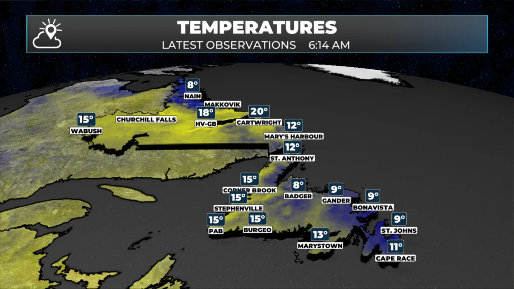
Temperatures are into the single digits and teens across the Province this morning.
Some showers are approaching the West Coast and will arrive within the hour.
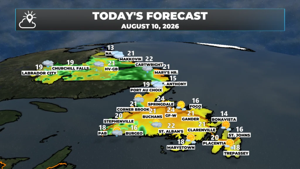
Showers and possible thunderstorms will be found in the Big Land today, while areas of rain and showers become more widespread on the West Coast of the Island and move eastward (slowly) today.
Highs across the board reach the mid-teens to lower 20s today.
This morning’s update is sponsored by Roebothan, McKay, Marshall.

Visit MakeTheCall.ca today to learn more about how the law firm can help you!
This animation of future satellite and radar does a good job showing how the rain showers will play out today across the province. Note how the activity is a bit more scattered in Labrador and more widespread across the Island. Also, note the time at the top of the loop; this should help you plan the day ahead!
Newfoundland Today
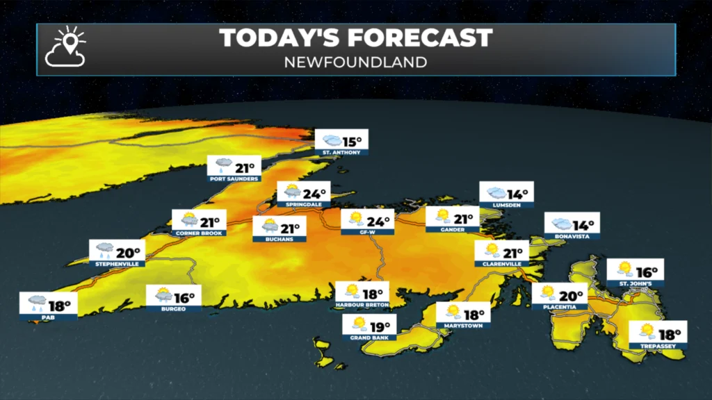
A frontal boundary will move into western areas of Newfoundland today, and the atmospheric reaction will be rain becoming more widespread from the Northern Peninsula to Port aux Basques this morning before it starts to push more astward this afternoon and evening. Areas of central and eastern Newfoundland, along with the majority of the South Coast, will stay predominantly dry today; however, showers will move into these areas this evening and tonight. The low cloud, fog and drizzle we are seeing outside of the West Coast should retreat to the coast this afternoon, and the second half of the day should be quite nice. Highs reach the mid-teens to lower 20s today.
Labrador Today
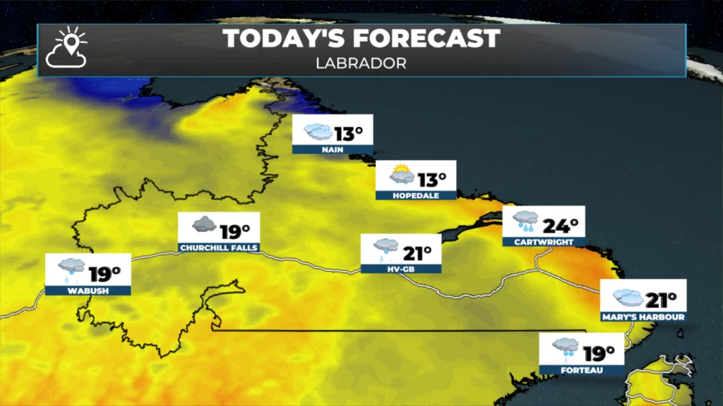
A weak area of low pressure will move across the Big Land today, and this will bring numerous showers and thunderstorms to the region. The activity will be found more in the west this morning, before shifting eastward into central and eastern Labrador this afternoon and evening. Highs reach the upper teens to mid-20s throughout the region.
The Look Ahead
An area of low pressure will move through the Gulf of St. Lawrence between tomorrow afternoon and late Wednesday or early Thursday, before continuing on into the North Atlantic. The track of this low will bring another round of unsettled weather to much of the province in that time frame. There is a risk of widespread thunderstorms over southwest and western Newfoundland and southeast Labrador between late tomorrow and early Wednesday. I’ll keep an eye on this closely!
My next update will be posted later today!
📱 Get the Sheerr Weather App in the Apple App Store and Google Play Store.
🗺️ Check out the Map Room to see all the latest weather observations for the Province.
🎥 Check out the Provincial Highway Cams to see 👀 what’s going on around our highways and
Good morning Eddie and thanks for the update