
TUESDAY MORNING’S WEATHER BRIEFING – AUGUST 4, 2026
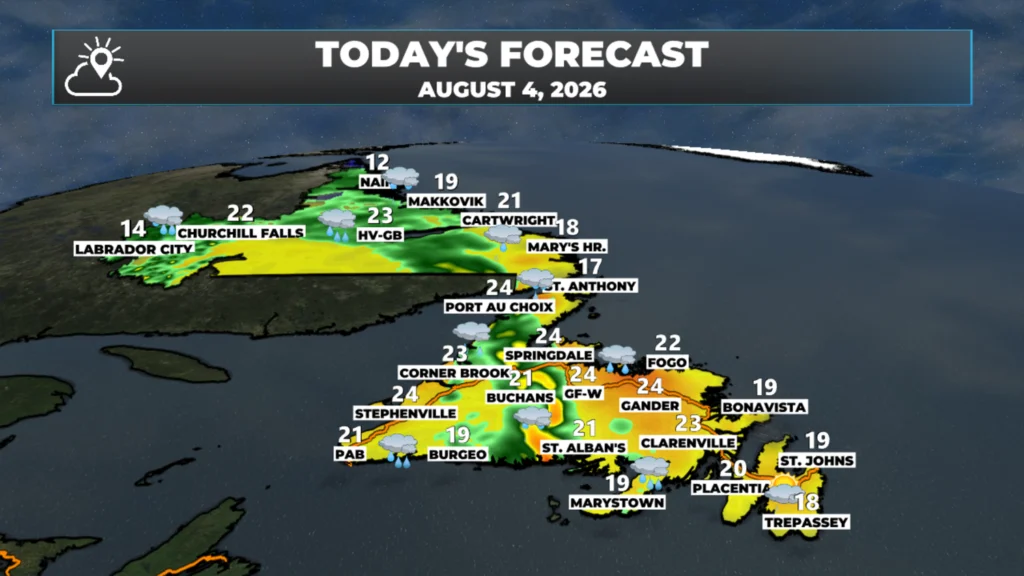
Good Tuesday Morning! Here are some highlights for the day(s) ahead:
An area of low pressure moves through Labrador today and brings rain, possible thunderstorms and breezy conditions to the Big Land.
That same low will drive a line of rain and showers across the Island today, and it will be quite humid to the east of the low.
The showers arrive on the West Coast this morning and then move east across the Island, arriving in the east late this afternoon or this evening.
Wind speeds will also be on the gusty side today, from the south as high as 50 to 60+ km/h (higher in the Wreckhouse area).
The weather improves in Labrador tomorrow, but remains unsettled on the Island as the low tracks overhead on Wednesday.
This morning’s update is sponsored by Roebothan, McKay, Marshall.

Visit MakeTheCall.ca today to learn more about how the law firm can help you!
The headline today is wind, not rain, even though there’s plenty of both around. A Wreckhouse Wind Warning is in effect through late this morning and into the afternoon, with southeast gusts as high as 100 km/h expected in that Wreckhouse/Codroy Valley stretch. If you’re driving through there today, especially in anything high-sided, be ready to get pushed around. That wind eases off tonight as the low that’s been parked near the Labrador-Quebec border pulls away.
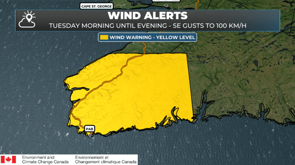
A Wreckhouse Wind Warning remains in effect until this evening (August 4, 2026).
That same low is also why Labrador City and Wabush remain under a Rainfall Warning this morning, with a good soaking still to come before things taper off later today. Meanwhile, on the Island, most areas are in for a wet one — periods of rain, some of it heavy at times, riding in on strong onshore southerly flow ahead of that departing low.
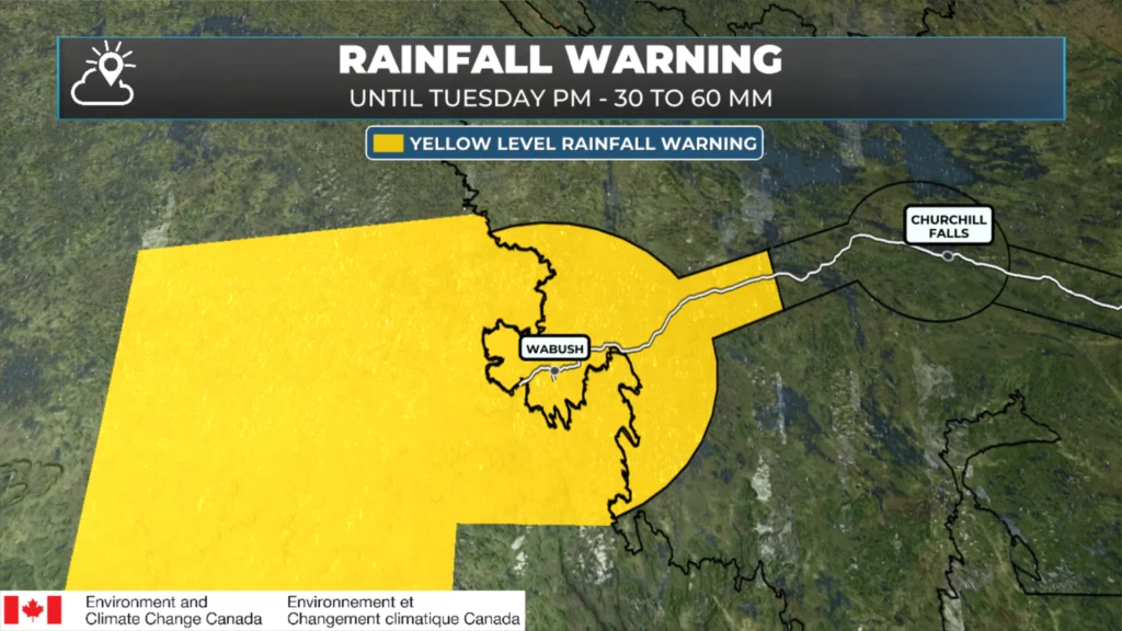
Rainfall Warning in effect for Labrador City and Wabush in effect until late today (August 4, 2026).
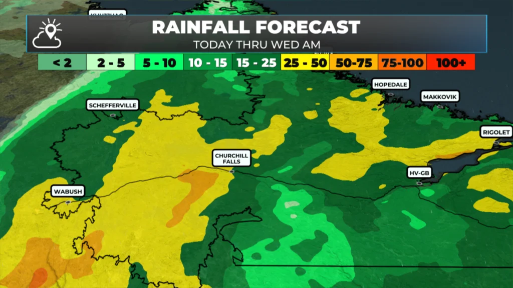
The Rainfall forecast for today into Wednesday – August 4, 2026.
Here’s how it breaks down region by region. The Avalon and the rest of eastern Newfoundland stay mostly cloudy through the day with highs near 18, then showers move in this evening and turn to rain overnight — coolest right along the coast where the onshore flow keeps things damp. Central sees rain showers build through the morning into a steady, soaking rain for the afternoon, windy too, with highs reaching the low-to-mid 20s. The West Coast, from Corner Brook to Stephenville, is looking at periods of rain for much of the day with highs in the low-to-mid 20s. The South Coast around Burgeo is cloudy and windy with periods of rain, gusty southeast winds, and higher rainfall totals than most. The Southwest is where the wind warning lives — expect a steady rain this morning giving way to showers this afternoon around Port aux Basques, on top of those Wreckhouse gusts. The Northern Peninsula and the Straits start with showers that build into steady rain by afternoon, windy as well, with highs around 18.
Labrador has the widest spread of the day. It’s warmest in Goose Bay, where highs push into the low 20s despite the rain, while it’s noticeably cooler out in Lab West with highs only in the mid-teens under heavier, more persistent rain — locally 25 to 50 mm is possible there, so watch for high water on smaller streams. Up the coast at Nain, it’s cooler again, near 12, with rain likely through the day.
Looking ahead, the bigger picture this week is a stalled frontal system out over the Great Lakes that’s bringing real flooding concerns to parts of Ontario and the US Midwest — it’s not a direct threat to us, but it is feeding warm, humid air into the Maritimes, where better rain and shower chances build by Wednesday into Thursday. Nothing tropical to worry about either; hurricane season is quiet for now, with no development expected anywhere in the Atlantic over the next week. I’ll have an updated forecast for the rest of the week posted later today!
My next update will be posted later today!
📱 Get the Sheerr Weather App in the Apple App Store and Google Play Store.
🗺️ Check out the Map Room to see all the latest weather observations for the Province.
🎥 Check out the Provincial Highway Cams to see 👀 what’s going on around our highways and
Good morning Eddie!Thanks for your update…
Great weather summary!
Always appreciate the bigger picture as well.
Regatta prediction??