
Monday Morning’s Weather Briefing — August 24, 2026
Good Monday Morning!
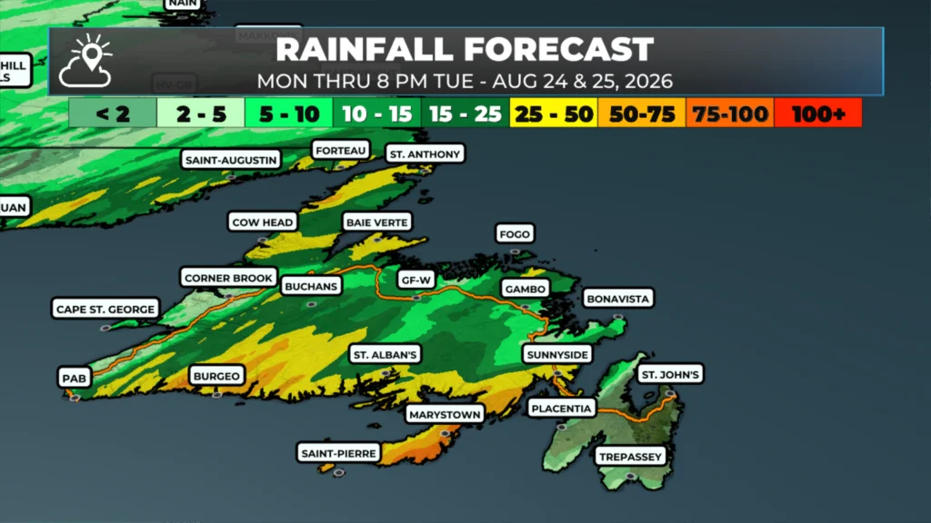
Areas of rain will persist over southern and southwestern Newfoundland today as a very damp weather pattern sets up shop.
We are seeing areas of heavy rain this morning over various areas of the Island, especially in the west and central regions.
Some areas will be hot and humid today and tomorrow, with humidex values rising into the upper 20s to mid-30s and air temperatures peaking in the middle to upper 20s.
Special Weather Statements and a Rainfall Warning are in effect for areas of southern Newfoundland (see ticker above).
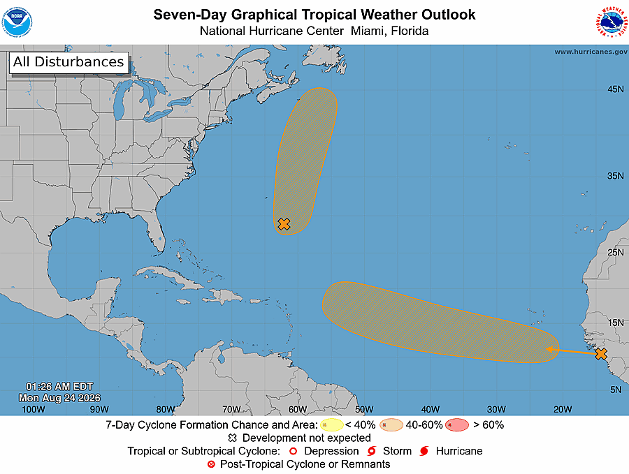
A Tropical Storm or depression may develop east of Bermuda today and track near southern Newfoundland tomorrow night.
This pattern changes after Wednesday, and the weather improves thereafter.
This morning’s update is sponsored by Roebothan, McKay, Marshall.

Visit MakeTheCall.ca today to learn more about how the law firm can help you!
TODAY’S OUTLOOK
There’s a slow-moving low-pressure center located over Quebec and a large high-pressure center offshore. Between the counter-clockwise flow around the low and the clockwise flow around the high, a large fetch of warm and humid air is being pushed (advected) into Atlantic Canada on southerly winds. On top of that, we are seeing areas of rain and showers across much of Newfoundland and parts of Labrador this morning. Some of the rain is heavy this morning. Southern areas will see pockets of rain and showers through the day, with another round of heavy rain moving in overnight. Watch for water pooling on the roads and a flood risk in the usual poor-drainage spots out that way. Another round of rain will move over southeastern and eastern Newfoundland Tuesday night into Wednesday as a secondary low takes hold. The rain from this system will be done by Wednesday morning.

A Speical Weather Statement is in effect for Channel-Port aux Basques through Tuesday for up to 60 mm of rain. A Rainfall Warning is in effect for Burgeo-Ramea until Wednesday for up to 90 mm of rain. Connaigre and the Burin Peninslua and under a Special Weather Statement for heavy rainfall expected Tuesday into Tuesday night.
Today’s Forecast
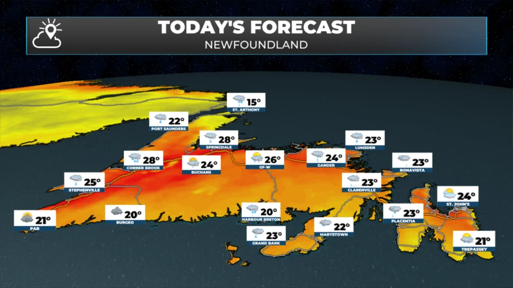
Eastern Newfoundland and the Avalon: A decent-looking day, all things considered — sunny and cloudy with scattered showers, highs near 24C. Humidex as high as 27. Winds pick up out of the south at 15 to 30 km/h.
Central: Periods of rain linger through the morning before things dry out for the afternoon, with highs around 25C. Humidex values as high as 31.
West Coast: Warm, but wet to start with periods of rain and showers this morning. Sun and clouds return this afternoon, along with a chance of showers and possibly thunderstorms. High near 27 with a humidex up to 32.
South Coast: Scattered thunderstorms this morning, becoming likely again this afternoon, a high near 20C, and southeast winds gusting 25 to 40 km/h. Rain continues into Tuesday with another 25 to 50 mm on top of what’s already fallen. Areas of fog along and near south-facing shores.
Southwest Coast: Showers this morning build into steady rain by afternoon, with thunder possible and a high around 21C. Southeast winds gust 15 to 30 km/h. The rain continues into Tuesday, mainly overnight, so this is a multi-day soaker for some of you.
The Great Northern Peninsula and the Straits: Rain early gives way to cloudy skies with afternoon showers, and it stays cooler here with a high near 15C. Southeast winds gust 15 to 30 km/h.
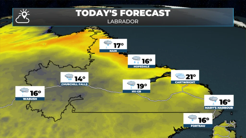
Labrador: A quieter, cooler day across the Big Land. Labrador West sees cloudy skies with periods of rain and a high around 16C. Goose Bay, stays mostly cloudy with rain arriving this afternoon and a high near 19C. The North Coast at Nain is cloudy with light rain moving in this afternoon and a high near 17C — coolest readings, as usual, right along the coast.
Looking ahead, keep half an eye on the southwest coast/south coast rain event into Tuesday and Wednesday. Farther offshore, there’s a system a few hundred miles southeast of Bermuda that forecasters are giving roughly even odds of becoming a tropical depression or storm over the next 48 hours. This low will track near the Avalon tomorrow night into Wednesday morning and may bring heavy rainfall to eastern Newfoundland if it does so. If this gets a name, it would be Dolly…
My next update will be posted later today!
📱 Get the Sheerr Weather App in the Apple App Store and Google Play Store.
🗺️ Check out the Map Room to see all the latest weather observations for the Province.
🎥 Check out the Provincial Highway Cams to see 👀 what’s going on around our highways and
Good morning Eddie and thanks for the update, have a great day
Thanks Eddie!
Thanks Eddie for weather update
Good morning Eddie thanks for the update. Have a great day 😊