
Tuesday Morning’s Weather Briefing — September 29, 2026
Good Tuesday Morning! Here are today’s highlights
The cool start this morning will be followed by another mild day across much of the Province.
Showers have arrived on the southwest coast and will spread eastward through the day.
Light rain will fall over much of southern and eastern Newfoundland between tonight and Wednesday morning.
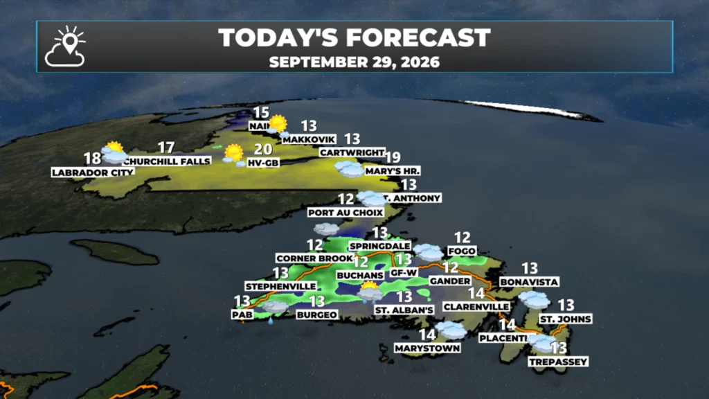
Highs reach the teens to nearly 20ºC across NL today, with the warmest readings in the Big Land.
This morning’s update is sponsored by Roebothan, McKay, Marshall.

Visit MakeTheCall.ca today to learn more about how the law firm can help you!
Tuesday is starting off on the chilly side for some areas of Newfoundland and Labrador, especially central, eastern, and even western, where temperatures are within a few ticks of the freezing mark. Meanwhile, in Labrador, temperatures in the west at this early hour are into the single digits, while teens are found in the east and north. Note that the temperatures you see may be warmer, as the images below live-update with the time of day and latest observations.


Temperatures this afternoon will peak in the teens and 20s across the Province once again. The warmest readings will be found in Labrador, while Newfoundland ends up a touch cooler. Part of that will be the sun, which Labrador will have lots of, while clouds increase on the Island and showers become more widespread as what’s left of that once-potent nor’easter moves in. It’s no longer potent.
Rain showers have arrived already on teh southwest coast and near the west coast and are moving eastward. Radar shows that nicely (animation below). We can also see that some of the showers are heavy (brighter colours) and that will be the case today. I’m not expecting heavy rainfall, but some of the showers will see will produce brief periods of heavy rain.
Futurecast will take us through the next 24 hours and should give you a good idea as to how the showers will play from this morning, through the day and tonight into early WEdnesday morning. Once these showers celar, early tomorrow morning, the weather across the Island will improve for Wednesday. Labrador reamisn steady as she goes on Wednesday. Things change a bit for the Big Land Thursday with some showers, while warmer temperature once again try to take hold on teh Island as we near the start of October!
Have a great day and follow along for updates! My detailed forecast will be posted this afternoon.
📱 Get the Sheerr Weather App in the Apple App Store and Google Play Store.
🗺️ Check out the Map Room to see all the latest weather observations for the Province.
🎥 Check out the Provincial Highway Cams to see 👀 what’s going on around our highways and
Good Morning Eddie. Thanks for weather forecast. Very little signs of Fall colors on our trees yet, but wouldn’t think it’s far off. Have a good day!!!
Thanks Eddie!
Good morning and thanks for the update Eddie