
Monday Morning’s Weather Briefing — October 5, 2026
Good Monday Morning! Here are today’s highlights
This morning begins dry; however, it will not last long. Rain spreads across the island from south to north between late morning and early afternoon. The day may even begin sunny most of the island north of any south-facing shores.
Webcams show that rain has already arrived in Labrador West. Rain will move across the Big Land from west to east throughout the day.
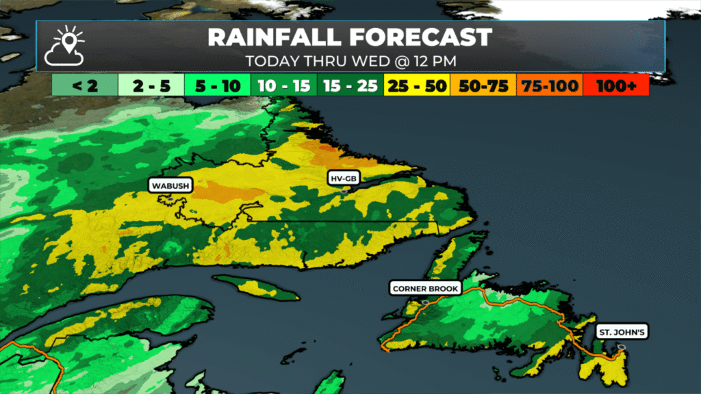
The rain today will last into Tuesday morning on the Island and Wednesday in parts of Labrador. Showers will linger on the West Coast and the Southwest Coast into Wednesday.
This is from a potent low-pressure system that will move through the region and intensify over the next couple of days. Along with rain and snow (Labrador’s higher terrain) high winds (80 to 100 km/h) are possible today and again tomorrow afternoon and evening. Particularly along the West Coast of Newfoundland and the northern coast of Labrador. Weather alerts are in effect.
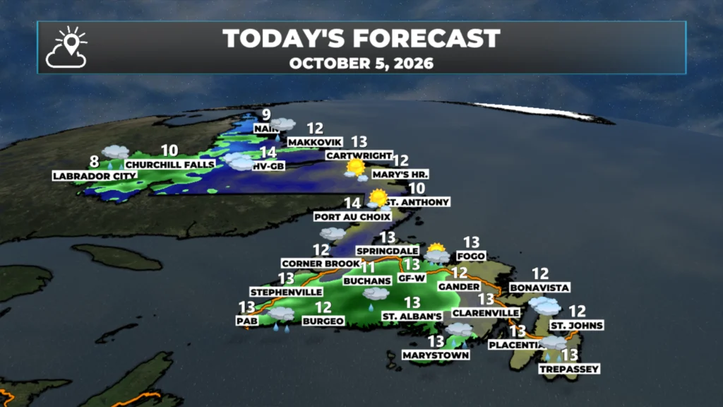
Temperatures today peak in the teens across the island, and in the single digits to low teens in Labrador.
This morning’s update is sponsored by Roebothan, McKay, Marshall.
Visit MakeTheCall.ca today to learn more about how the law firm can help you!
The setup this morning features an area of high pressure to the east of Newfoundland, with an area of low pressure taking shape over Quebec to its west. South of that low, rain is already falling across Quebec, the Maritime provinces, and now southwestern and southern Newfoundland.

This low is in no hurry. It’s developing fairly slowly, waiting on some upper-level features to come together before it makes its move across Newfoundland and Labrador, which really happens tomorrow. As it spins its way through Quebec today, rain arrives in southern Newfoundland late morning into early afternoon, reaches the Avalon through the afternoon and evening, and overspreads virtually the rest of Newfoundland later today into tonight. The rain becomes heavy at times. In Labrador, rain arrives in the west this morning and slowly works its way eastward through the day. A few warnings are already in effect: a rainfall warning for the southeast Avalon, and a wind warning for the Wreckhouse area and Bay St. George, which may be expanded.
Winds are the other story. With a tight pressure gradient wrapping around the system, it’ll be breezy from today right through to potentially Wednesday, and especially tomorrow. Watch for stronger winds in northern Labrador and, as the low works into the Gulf of St. Lawrence tomorrow, over western Newfoundland.
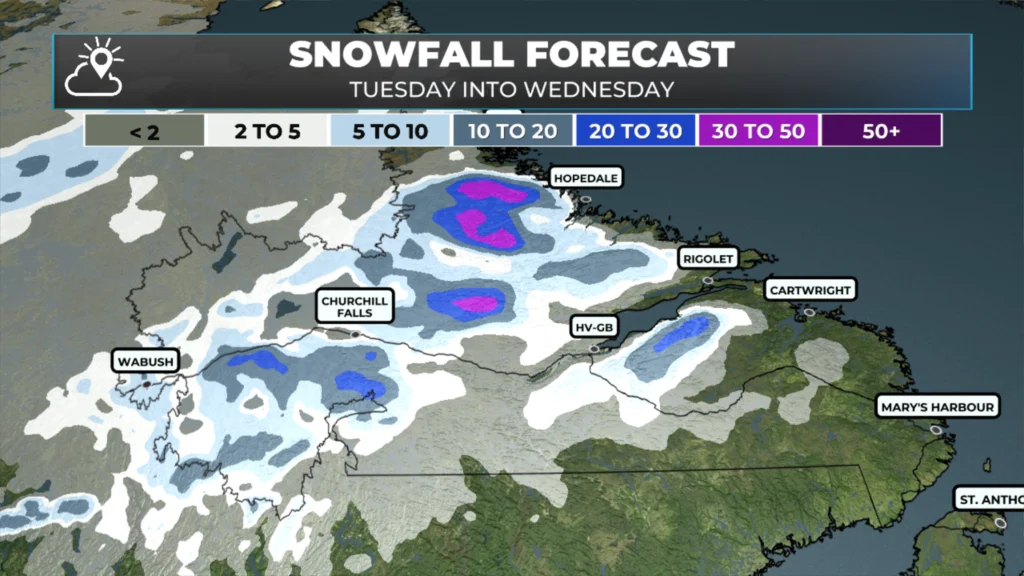
The heaviest rain across Newfoundland holds off until tonight, and most of it is wrapping up by tomorrow morning. Behind it, showers and rain linger for western areas through Wednesday, especially over the higher terrain. Northern and western Labrador see rain Tuesday into Wednesday as well. And while this system starts warm, it’ll bring significant snowfall to Labrador’s higher terrain, mainly Tuesday into Tuesday night, though that’s limited to the higher elevations.
Temperature-wise, we’re in the low teens across most of Newfoundland today, climbing briefly into the upper teens tomorrow before we’ll see whether they fall back or hold. Bottom line: a wet, breezy stretch ahead for Newfoundland tonight into tomorrow, lingering showers out west through Wednesday, and snow piling up on Labrador’s higher terrain. It all wraps up by Wednesday morning across Newfoundland and by Wednesday in Labrador. I’ll have a more detailed forecast posted for you later today.
📱 Get the Sheerr Weather App in the Apple App Store and Google Play Store.
🗺️ Check out the Map Room to see all the latest weather observations for the Province.
🎥 Check out the Provincial Highway Cams to see 👀 what’s going on around our highways and
Good Morning Eddie
A very detailed forecast. It is what it is, I realize our summer is OVER. Thanks for keeping us updated…… you’re the best! Enjoy your day!