
Friday Morning’s Weather Briefing — November 20, 2026
Good Friday Morning!
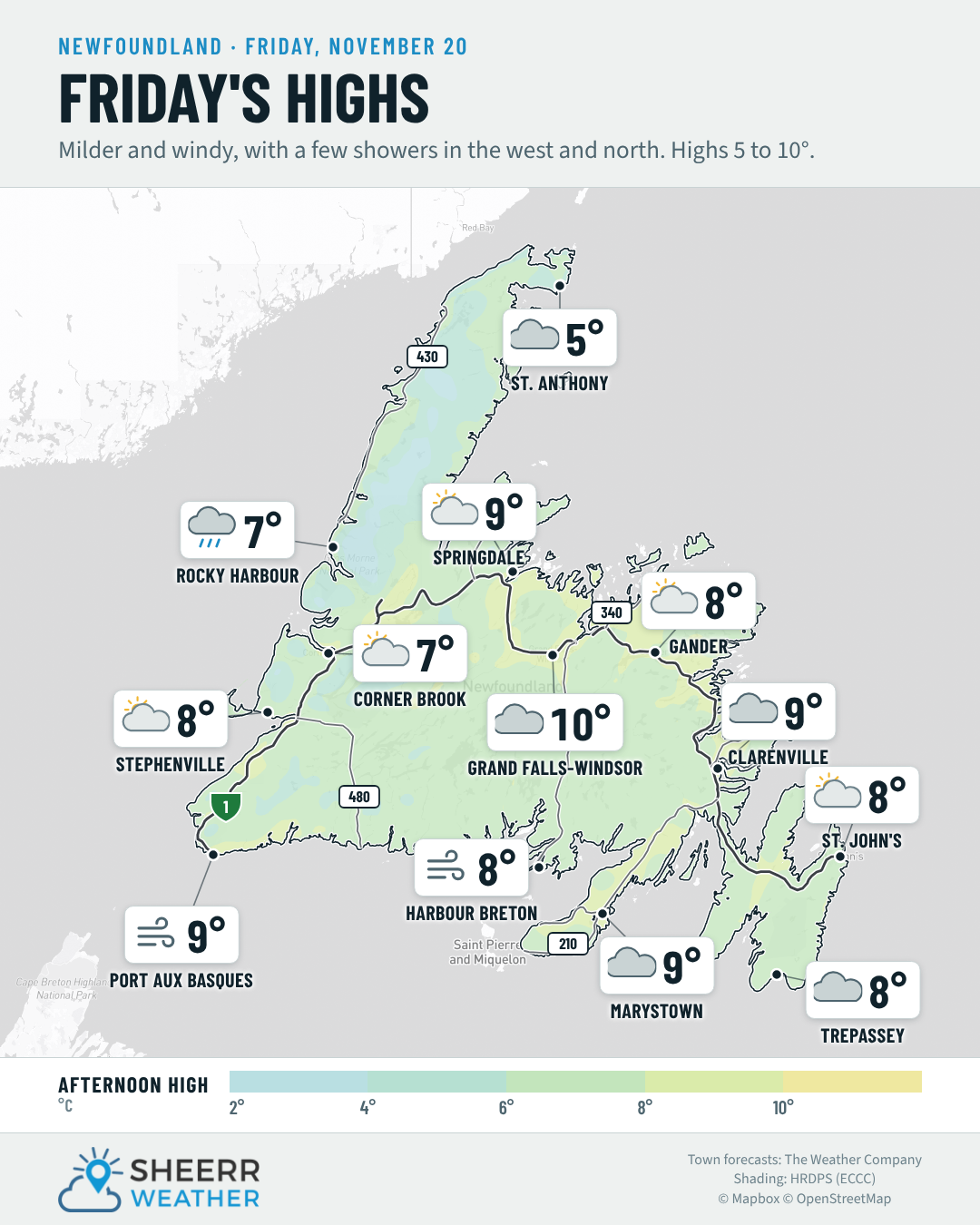
- A chilly start on the Island after a clear night, but it turns milder today, with highs of 5° in St. Anthony to 9° in Grand Falls-Windsor.
- Windy, with southwest winds of 25 to 40 km/h for most of us, and 40 to 55 km/h on the Northern Peninsula and in the Straits, with gusts over 65 km/h in spots.
- A few showers on the west coast and the Northern Peninsula, mainly this afternoon, with steadier rain around Rocky Harbour.
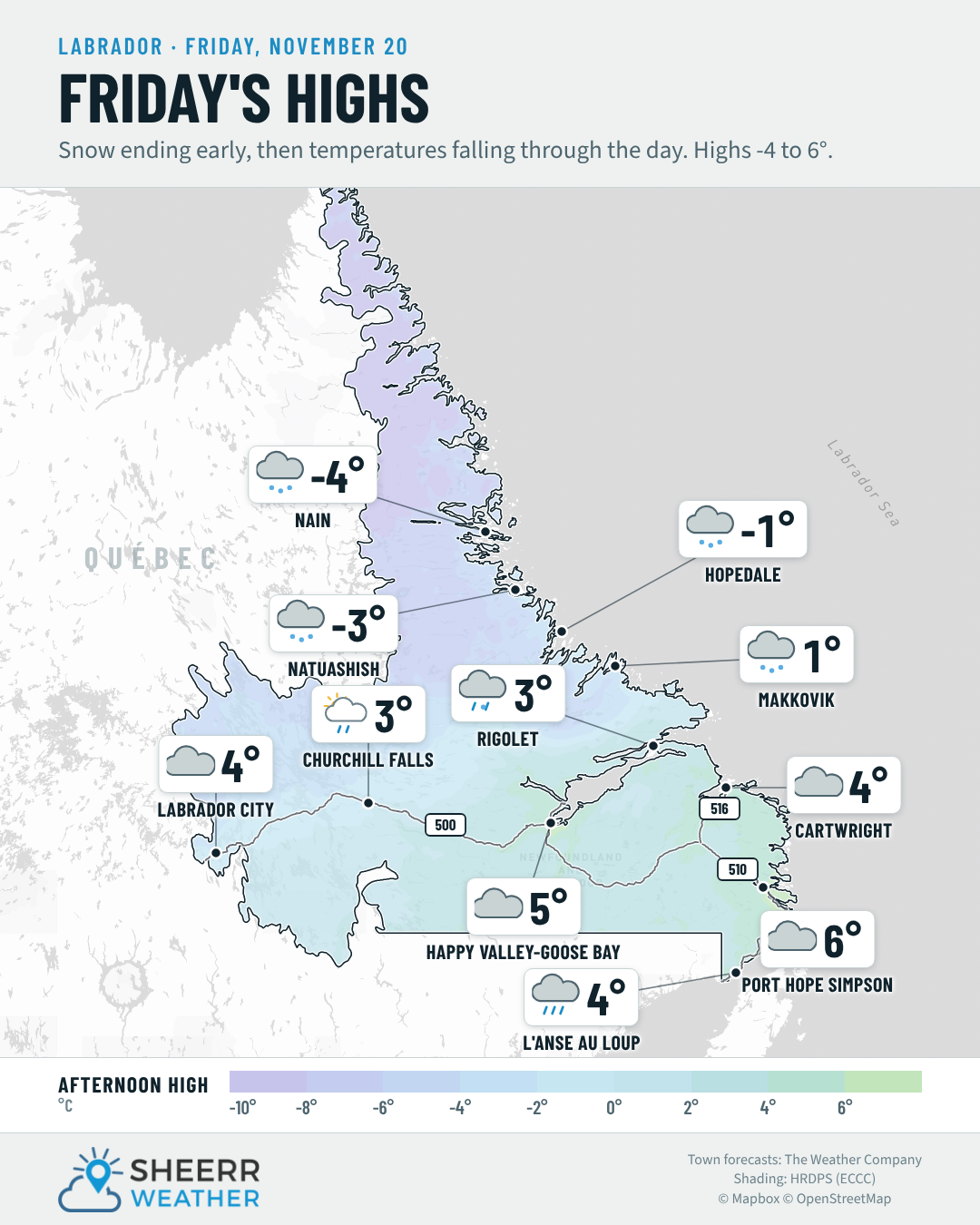
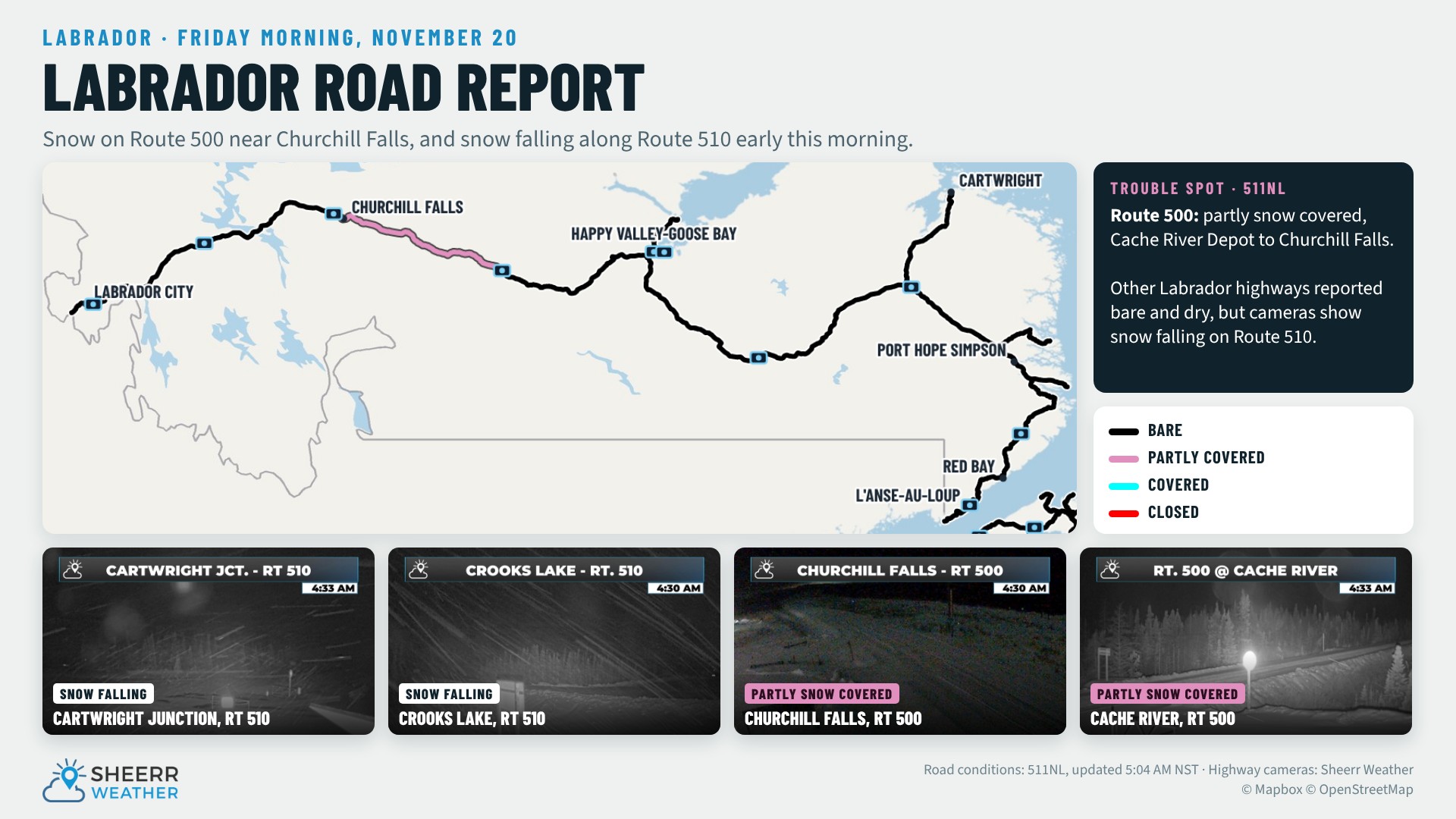
- Overnight snow tapers off in Labrador this morning, with 2 to 3 cm in Churchill Falls, Hopedale and Nain. Temperatures fall through the day, and tonight is cold, with lows of -9° to -13°.
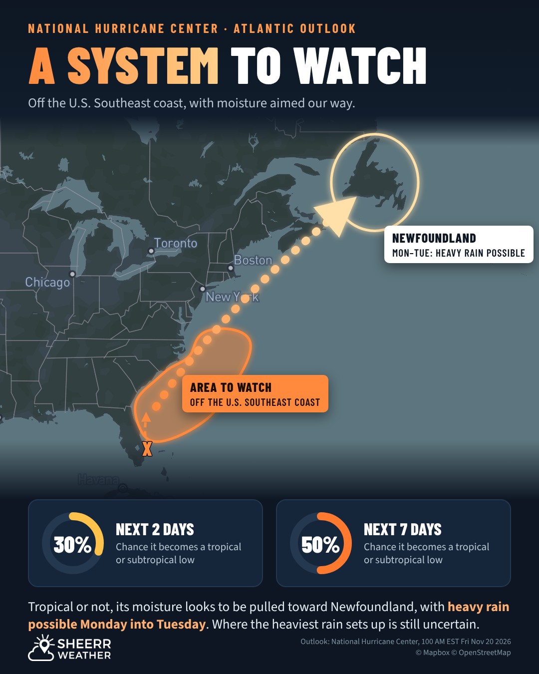
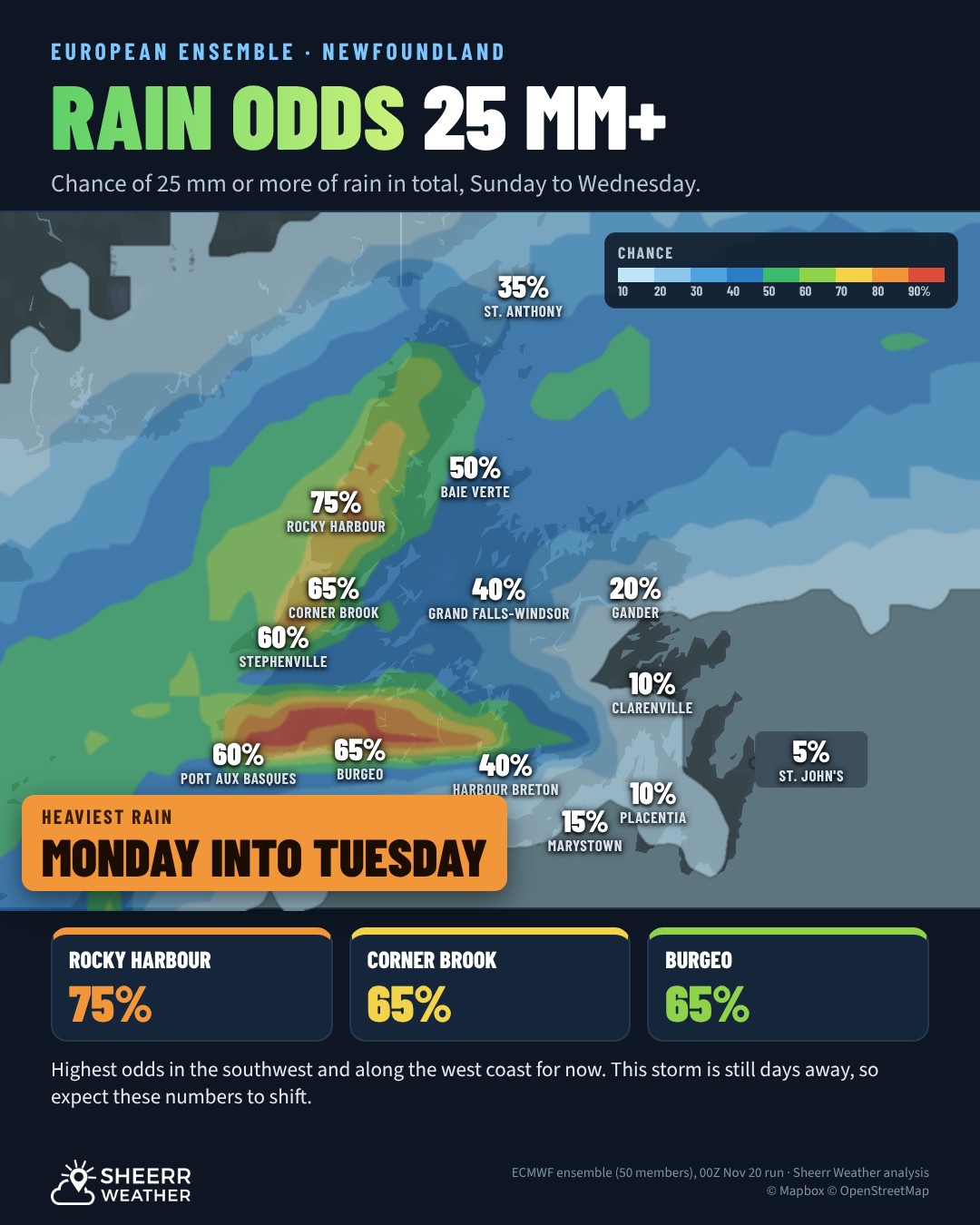
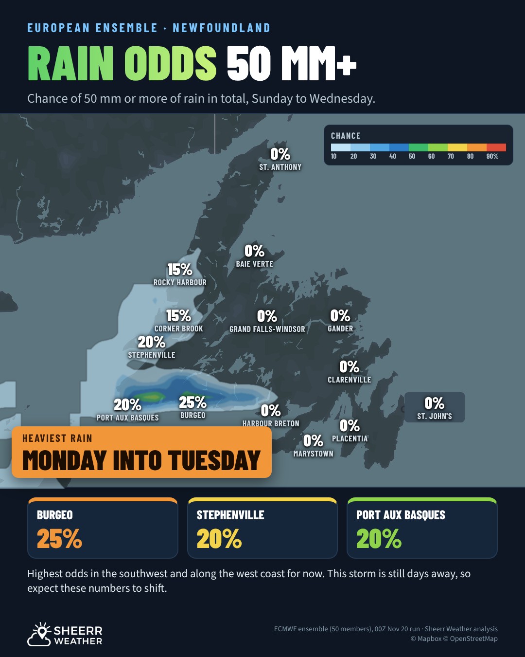
- A cooler Saturday, a mild Sunday, then heavy rain looks likely for Newfoundland Monday into Tuesday, especially along the south coast.
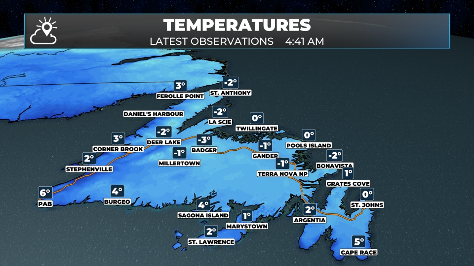
It’s a chilly start to Friday after a mostly clear night, with temperatures near or a little below the freezing mark across much of the Island, so give yourself a few extra minutes to scrape the windshield.
A southwest flow takes over today, and that means a milder, breezier afternoon. Expect a mix of sun and cloud this morning, turning cloudier this afternoon. It’s breezy, with southwest winds of 25 to 40 km/h for most areas, 30 to 50 km/h around parts of the coast, and along and near the Strait of Belle Isle, gusts could top 65 km/h. A few showers move across the west coast and the Northern Peninsula, mainly this afternoon. Highs of 5° to 6° on the Northern Peninsula, and 7° to 9° elsewhere. It turns windy again tonight on the northeast coast, with west-northwest winds of 40 to 55 km/h, and lows of -5° to 2°.
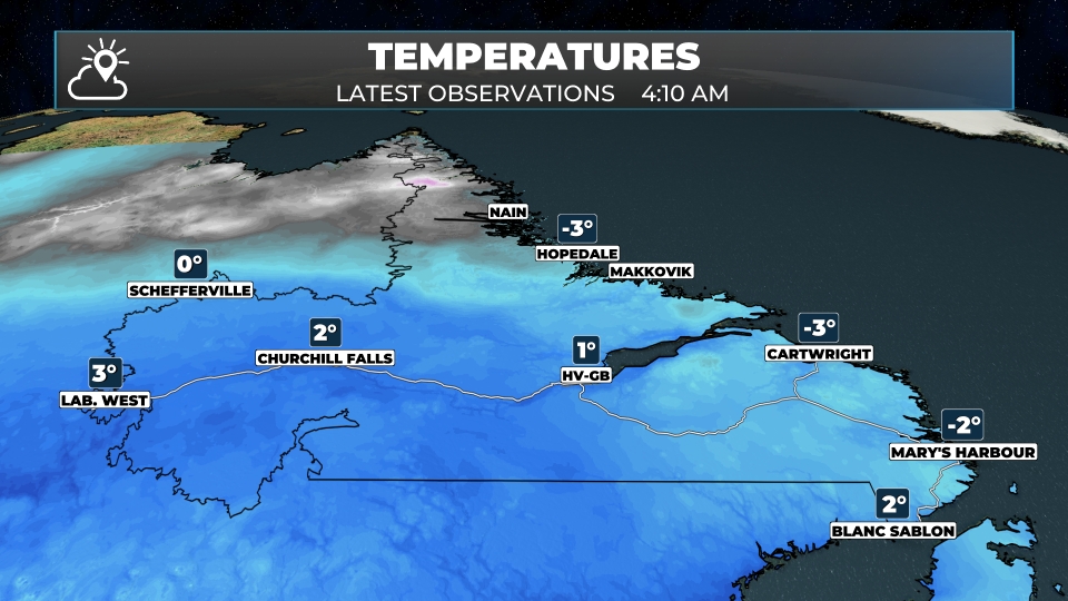
In Labrador, snow overnight brings 2 to 3 cm to Churchill Falls, Hopedale and Nain, and less than 2 cm to Goose Bay, while Lab West saw some rain showers. The snow tapers off this morning. Temperatures peak early, with morning highs of 3° to 6° in Lab West, Churchill Falls, Goose Bay and along the south coast, then fall through the day, to -5° to -3° by afternoon in the west. Hopedale is windy, with snow showers this morning and west-northwest winds of 30 to 50 km/h, gusting over 65 km/h, and a high of -1°. Nain stays near -4°. Tonight is cold across the Big Land, with lows of -9° in Lab City, Goose Bay and Cartwright, -10° in Hopedale, -11° in Nain and -13° in Churchill Falls.
This morning’s update is sponsored by Amplifon Hearing Care Experts, formerly Newlife Hearing!
Book your hearing aid Test Drive today at amplifon.com or call (709) 800-7343!
Eastern Newfoundland / the Avalon: A mix of sun and cloud this morning, then cloudy, with a slight chance of a shower. Wind southwest 25 to 40 km/h, and 30 to 50 km/h in exposed areas. High 8° to 9°. Tonight, cloudy periods. Wind west 15 to 30 km/h, and 40 to 55 km/h near Bonavista. Low 0° to 2°.
Central: Cloudy, with a slight chance of a shower. Wind southwest 15 to 30 km/h. High 8° to 9°. Tonight, partial clearing, with a chance of flurries. Low -3° to 0°.
West Coast: Mostly cloudy, with showers this afternoon and steadier rain in the north. Wind southwest 15 to 30 km/h. High 7° to 9°. Tonight, partial clearing. Low -2° to 1°.
South Coast: Cloudy and windy. Wind southwest 30 to 50 km/h, with gusts over 65 km/h in exposed areas. High 8° to 9°. Tonight, partly cloudy. Low near 1°.
Southwest / Wreckhouse: Sun and cloud this morning, then cloudier. Wind west-southwest 25 to 40 km/h, with gusts over 65 km/h. High 9°. Tonight, partly cloudy. Wind northwest 25 to 40 km/h. Low 1°.
GNP and the Straits: Cloudy and windy, with flurries in the north this morning, then showers this afternoon. Wind southwest 40 to 55 km/h, gusting over 65 km/h. High 5° to 7°. Tonight, clearing and colder, with gusty northwest winds. Low -5° to -2°.
Labrador / the Big Land: Snow ending this morning, then cloudy. Snowfall amounts of 2 to 3 cm in central and northern areas. Temperatures falling through the day after early highs of 3° to 6° in the west and south, and near -4° to -1° on the north coast. Wind west-northwest 30 to 50 km/h on the north coast, gusting over 65 km/h. Tonight, cold. Low -13° to -9°.
Looking ahead: Saturday is cooler on the Island, with highs of 0° in St. Anthony to 7° on the south coast, and light snow arrives in Lab West Saturday evening, spreading east overnight and ending as rain on Sunday. Sunday is milder on the Island, with highs of 6° to 12°. Then a system that started off the coast of Florida brings heavy rain to Newfoundland Monday into Tuesday, with the southwest and the west coast currently the favoured spots for the heaviest amounts. Meanwhile, much colder air settles into Labrador early next week.
📱 Get the Sheerr Weather App in the Apple App Store and Google Play Store.
📍 Want more detail for where you live? Check out our new Regional Forecast pages for current conditions, local alerts, highway cams and the forecast for your area: Avalon · Eastern · Burin Peninsula · South Coast · West Coast · Long Range Mountains · Central · GNP & the Straits · Labrador West · Central Labrador · Labrador North Coast · Labrador South Coast
🗺️ Check out the Map Room to see all the latest weather observations for the Province.
🎥 Check out the Provincial Highway Cams to see 👀 what’s going on around our highways.
