
Tuesday Morning’s Weather Briefing — November 10, 2026
Good Tuesday Morning!
- A cloudy, mild start on the Island, with temperatures of 3° to 8° this morning: 6° in St. John’s, 3° in Gander and Grand Falls-Windsor, and 8° in Marystown and Harbour Breton.
- A band of rain moves through the south coast and central Newfoundland today, from the Connaigre Peninsula up toward Grand Falls-Windsor. Up to 15 mm around Harbour Breton, with lighter amounts in Gander. Most of the Avalon and the west stay mainly dry until tonight.
- Rain spreads across the east tonight, and Wednesday turns wet and windy. West winds gust over 65 km/h on the Avalon and Burin Peninsula, and northwest winds reach 40 to 55 km/h around the Bonavista Peninsula.
- Colder air brings snow into the picture Wednesday afternoon and night, mainly over higher ground in the west. Rocky Harbour has about a 60% chance of 10 cm or more by Thursday afternoon, Corner Brook about 20%, and most of the Island close to 0%. Snow will, for the most part, be relegated to areas inland and over higher terrain
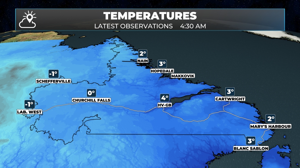
- Labrador: light snow in Lab West this morning, with -2° in Labrador City. A steadier snow arrives Wednesday night, with 5 to 10 cm possible in Churchill Falls, and also the Happy Valley-Goose Bay area has a good chance of a significant snowfall from later tomorrow into Thursday, before a change to rain Thursday afternoon.
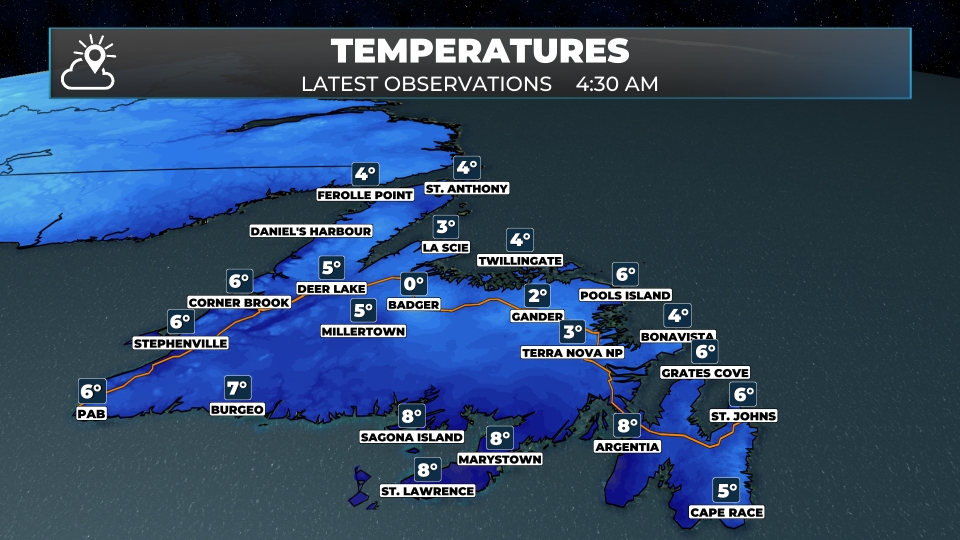
It’s a grey but mild start to Tuesday on the Island. Temperatures are running 3° to 8° this morning under a thick deck of cloud, with a few spots of fog, including around St. Anthony. Winds are light for most areas, though Bonavista has a southeast breeze gusting near 35 km/h.
Today’s main feature is a narrow band of rain that develops across the south coast and works north through central Newfoundland, roughly from the Connaigre Peninsula toward the Bay d’Espoir Highway, Grand Falls-Windsor and the Badger area. Harbour Breton could pick up close to 12 mm today, and Marystown about 6 mm. The rain stays mostly west of the Avalon and southwest of the Bonavista Peninsula, where it’s cloudy with just a slight chance of a shower. St. John’s should see fog develop this afternoon, with a high near 7°.
Tonight, that rain spreads east, becoming steady across the Avalon, Bonavista and Burin peninsulas overnight, with about 6 mm by morning. Lows of 3° to 6°.
In Labrador, there’s light snow in Labrador City and Churchill Falls this morning, with -2° in Lab City and 0° in Churchill Falls. It tapers to cloud and a few flurries this afternoon. Goose Bay starts with some light rain and 4°, and Hopedale is windy this morning, with southeast winds gusting to 55 km/h. Nain has rain changing to a rain and snow mix this afternoon. Tonight turns colder in the west, with lows near -6° in Labrador City and Churchill Falls.
This morning’s update is sponsored by Amplifon Hearing Care Experts, formerly Newlife Hearing!
Book your hearing aid Test Drive today at amplifon.com or call (709) 800-7343!
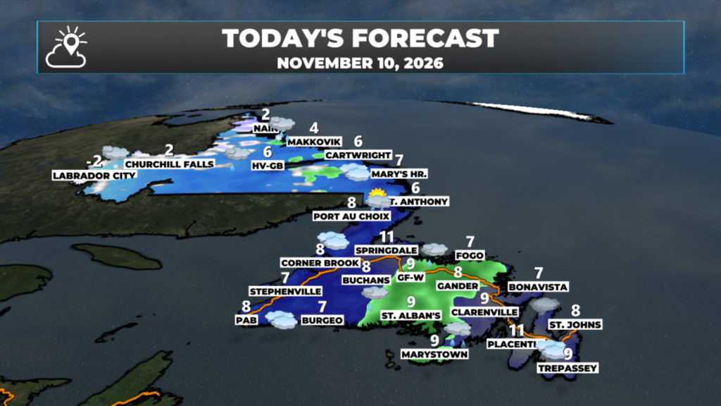
Eastern Newfoundland / the Avalon: Mostly cloudy in St. John’s, with fog developing this afternoon and a high near 7°. Cloudy around Argentia and Placentia, with a high near 11°, and on the Bonavista Peninsula, with southeast winds of 25 to 40 km/h and a high near 8°. Showers this evening, becoming a steady rain overnight, about 6 mm. Lows of 3° to 4°.
Central: Showers early in Gander, becoming a steady light rain this afternoon, with a high near 9° and south-southeast winds of 15 to 25 km/h. Occasional light rain in Grand Falls-Windsor, with a high near 9°. More rain tonight, with lows of 3° to 4°.
West Coast: Cloudy, with highs of 8° to 9° in Corner Brook, Deer Lake and Stephenville. A few showers this morning in Rocky Harbour, with a high near 8°. Showers tonight, with lows of 3° to 4°.
South Coast: Rain likely today, with about 12 mm around Harbour Breton and 6 mm around Marystown, and highs of 8° to 9°. Cloudy in Burgeo, with a high near 8°. Periods of rain tonight from the Burin Peninsula to Harbour Breton, with lows of 4° to 6°.
Southwest / Wreckhouse: Cloudy in Port aux Basques, with a high near 8° and southwest winds of 10 to 15 km/h. Mostly cloudy tonight, with northwest winds of 15 to 25 km/h and a low near 4°.
GNP and the Straits: Fog this morning in St. Anthony, then showers this afternoon, with a high near 6°. Cloudy around Port au Choix, with a high near 8°. Rain tonight, with lows of 2° to 4°.
Labrador / the Big Land: Light snow this morning in Labrador City and Churchill Falls, then cloudy this afternoon, with highs of -1° to 2°. Light rain this morning in Goose Bay, with a high near 5°. Cloudy in Cartwright and Mary’s Harbour, with highs of 6° to 7°, and light rain this evening in Mary’s Harbour. Rain changing to a rain and snow mix in Nain this afternoon, with a high near 2°. Windy in Hopedale this morning, with southeast winds of 30 to 50 km/h. Lows tonight of -6° in Labrador City and Churchill Falls to 0° to 2° on the coast.
Looking ahead: Wednesday is wet and windy across most of the Island. Expect 6 to 12 mm of rain in the east and central, and heavier rain on the Northern Peninsula, where St. Anthony could see more than 25 mm. West to northwest winds pick up, gusting over 65 km/h on the Avalon and Burin Peninsula. As colder air moves in, rain mixes with and changes to snow over higher ground in western and central Newfoundland Wednesday afternoon and night, and into Thursday morning.
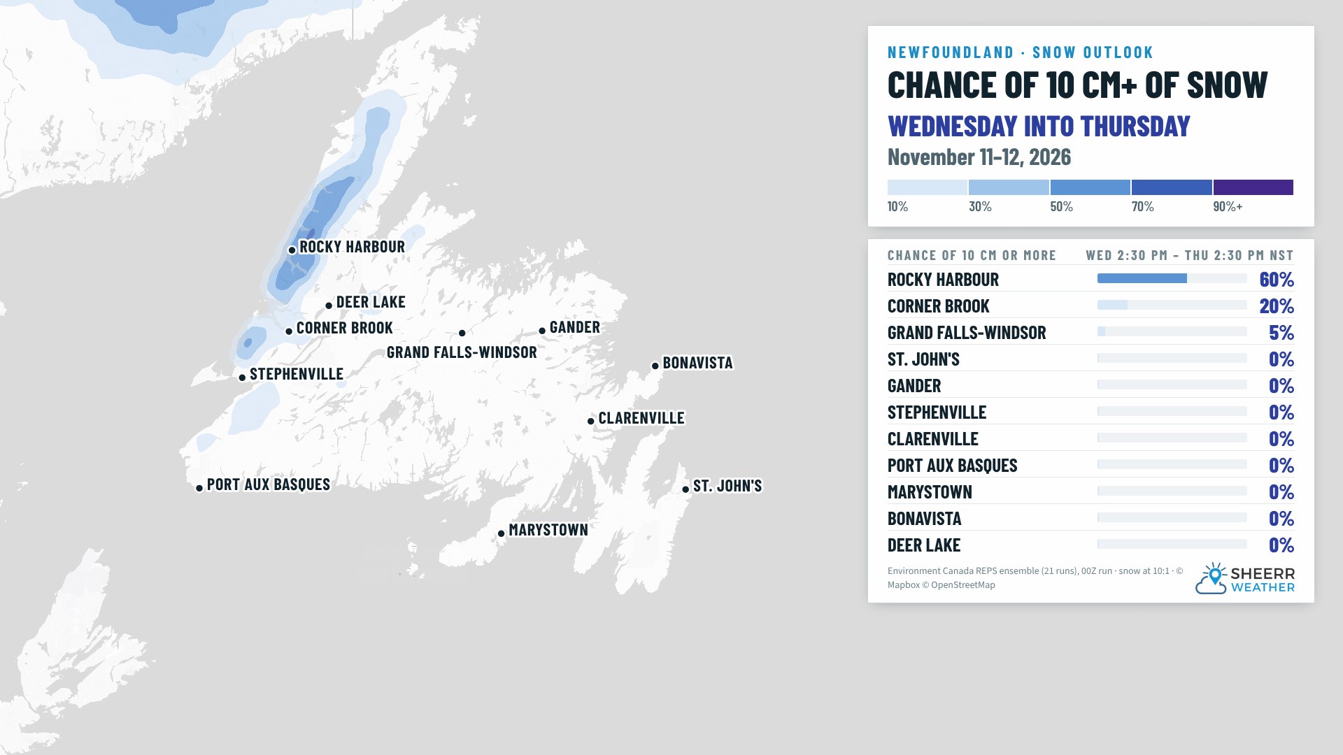
The best chance of 10 cm or more is in the Long Range Mountains, with Rocky Harbour near 60%. Corner Brook is around 20%, and for most of the Island, including St. John’s, Gander and Grand Falls-Windsor, the chance is close to 0%. Some wet flurries or a rain and snow mix are possible in central areas Wednesday night.
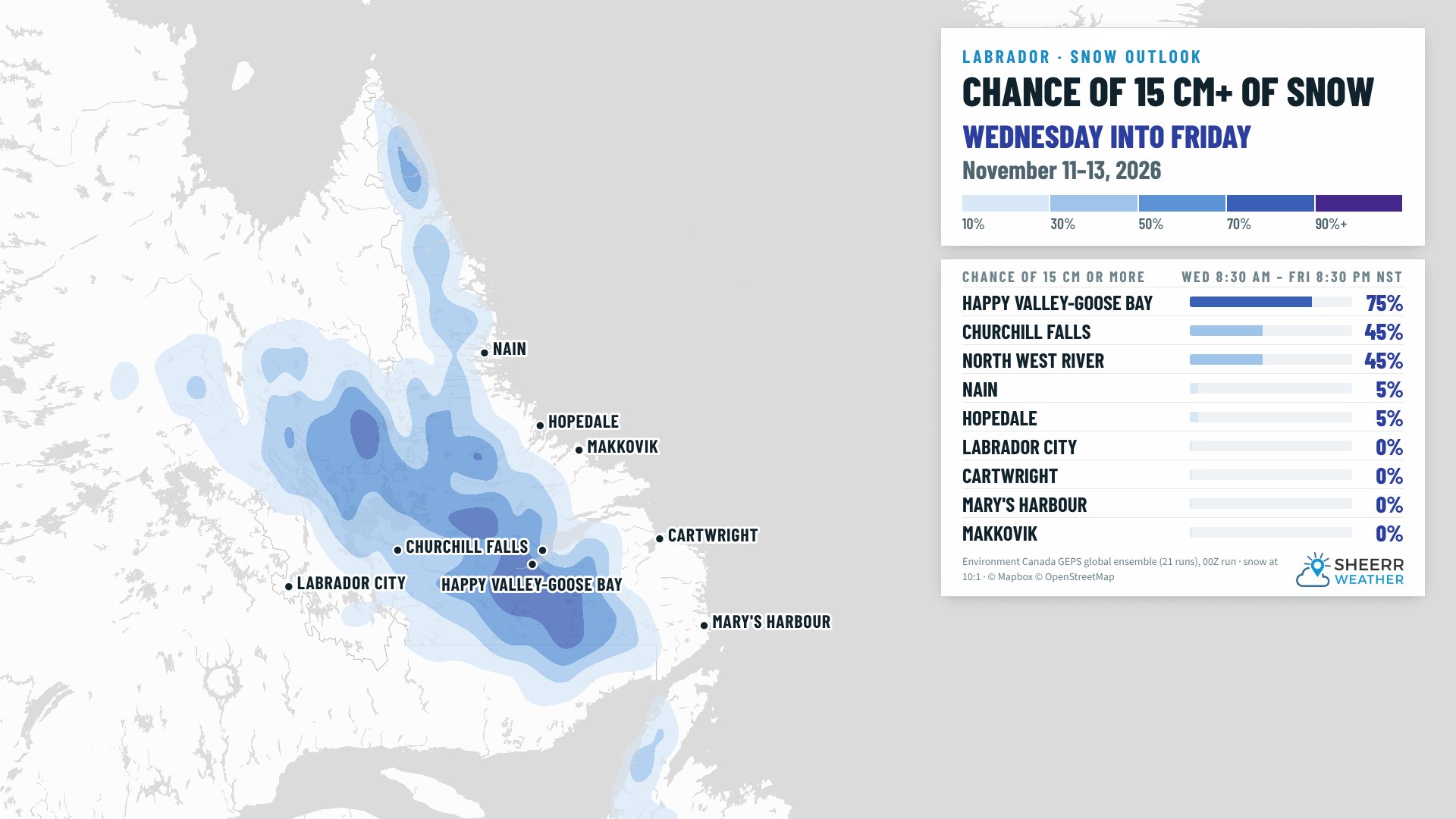
In Labrador, snow develops Wednesday night, with 5 to 10 cm possible in Churchill Falls. Happy Valley-Goose Bay has about a 75% chance of 15 cm or more from Wednesday into Friday, though the snow could mix with or change to rain at times Thursday, which would cut into those totals. Churchill Falls and North West River are near 45%. Labrador City is looking at a few centimetres Wednesday night and more snow Thursday, about 5 to 10 cm by Friday. Mary’s Harbour could see more than 25 mm of rain Wednesday.
📱 Get the Sheerr Weather App in the Apple App Store and Google Play Store.
📍 Want more detail for where you live? Check out our new Regional Forecast pages for current conditions, local alerts, highway cams and the forecast for your area: Avalon · Eastern · Burin Peninsula · South Coast · West Coast · Long Range Mountains · Central · GNP & the Straits · Labrador West · Central Labrador · Labrador North Coast · Labrador South Coast
🗺️ Check out the Map Room to see all the latest weather observations for the Province.
🎥 Check out the Provincial Highway Cams to see 👀 what’s going on around our highways.