
Saturday Morning’s Weather Briefing — October 24, 2026
Good Saturday Morning!
- What was left of Josephine packed a punch yesterday: Sagona Island gusted to 129 km/h, the strongest in the province, and Burgeo hit 101. The Wind Warning has ended.
- Rain moves back up the Southern Shore and over the Avalon today, with 5 to 15 mm, most of it on the southern Avalon, and northeast winds still gusting over 65 km/h.
- It stays windy near Fortune Bay and the Connaigre Peninsula this morning, with gusts up to 80 km/h.
- Central and western Newfoundland dry out, with sunshine on the West Coast this afternoon and highs of 4 to 9.
- In Labrador, a nice day in the Big Land, with a mix of sun and cloud and highs of 6 to 12, after some freezing drizzle around Cartwright this morning.
Yesterday was a windy one! Environment Canada’s end-of-day numbers are in, and they show the strongest gusts were along the South Coast and Placentia Bay, with northeasterly winds roaring as Josephine’s leftovers passed south of Newfoundland.
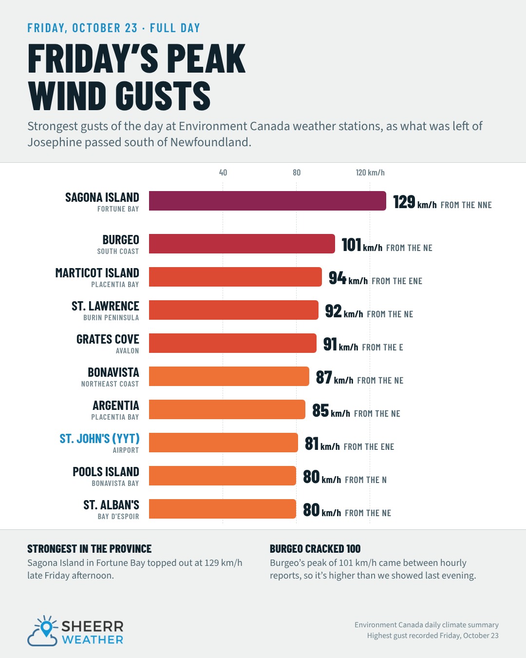
Here are Friday’s peak wind gusts:
- Sagona Island: 129 km/h
- Burgeo: 101 km/h
- Marticot Island: 94 km/h
- St. Lawrence: 92 km/h
- Grates Cove: 91 km/h
- Bonavista: 87 km/h
- Argentia: 85 km/h
- St. John’s International Airport: 81 km/h
- Pools Island and St. Alban’s: 80 km/h
Sagona Island’s 129 km/h came late in the afternoon, and Burgeo’s 101 came between the hourly reports, so it was even windier there than the numbers we shared last evening. It also stayed gusty overnight, with Sagona Island still gusting to 102 km/h just after midnight and Burgeo to 80 early this morning. For rain, the St. John’s airport picked up 18.8 mm yesterday, with 17.3 mm in St. Lawrence and 12.4 mm in Winterland.
Today, the low that was once Josephine stalls and swirls out over the Grand Banks, and that sends one more area of rain back toward the Avalon. If you’re on the Avalon Peninsula, it may start dry, but don’t let it fool you. Rain works north up the Southern Shore this morning and becomes steadier this afternoon, with 5 to 15 mm on the way, the most on the southern Avalon. Northeast winds 30 to 50 km/h will gust over 65 at times, and highs only reach 5 or 6. It clears out tonight, with lows near the freezing mark.
Elsewhere, it’s a cloudy start across much of eastern and central Newfoundland, but the West Coast and the Northern Peninsula see sunshine this afternoon. It’s going to be a cool night, with lows near or below freezing across much of the Island.
ECT 50 runners: it’s a cool, breezy day for the race from Pouch Cove to Quidi Vidi Lake. Expect temperatures of 4 to 6 along the course, winds gusting near 60 km/h early on and in the 50s by the afternoon, and some rain showers, especially closer to lunchtime. Dress accordingly, and hats off to all of you!
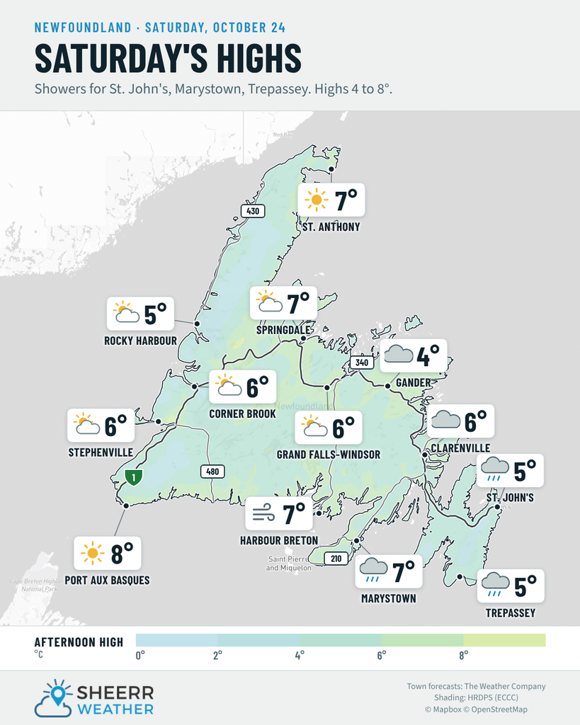
Eastern Newfoundland / the Avalon: Showers this morning becoming a steady rain this afternoon on the Avalon, with 5 to 15 mm, the most on the southern Avalon and Southern Shore (around 12 mm). Windy, with northeast winds 30 to 50 km/h, occasionally gusting over 65. Highs of 5 to 6. Rain ends this evening, then clearing overnight, with northwest winds 25 to 40 and lows of 0 to 2. Overcast around Clarenville and Terra Nova, with a high near 6. Gusty on the Bonavista Peninsula this morning, with northeast winds 25 to 40 gusting near 65, then partly cloudy tonight, with lows near minus 1 to 1.
Central: Cloudy this morning in Gander, becoming partly cloudy in the Exploits Valley and Notre Dame Bay this afternoon. Northeast winds 15 to 30 km/h in Gander, lighter elsewhere. Highs of 4 to 8. Clear to partly cloudy tonight, with lows near minus 1.
West Coast: Clouds this morning give way to sunshine this afternoon in Corner Brook, Deer Lake and the Bay St. George area. North winds 10 to 25 km/h. Highs of 6 to 9. Mainly clear tonight, with lows of 1 to 3.
South Coast: Rain this morning on the Burin Peninsula, with rain and snow near the southern tip, changing to a few showers this afternoon. Windy, with north-northeast winds 30 to 50 km/h gusting over 65, and 40 to 55 gusting to 80 on the Fortune Bay side and the Connaigre Peninsula, easing this afternoon. Partly cloudy in Burgeo, with a high near 8, and cloudy in Bay d’Espoir, with a high near 6. Clear tonight, with lows of minus 1 to 3.
Southwest / Wreckhouse: Partly cloudy, with a high near 8 in Port aux Basques. North winds 15 to 30 km/h, becoming northwest 25 to 40 tonight, with a low near 4. You can always check the Wreckhouse Wind Gauge before you travel.
GNP and the Straits: Sunny to partly cloudy, with highs of 5 to 7. Southwest winds 15 to 30 km/h, and 25 to 40 in the Straits. A few clouds tonight, with lows of 1 to 4.
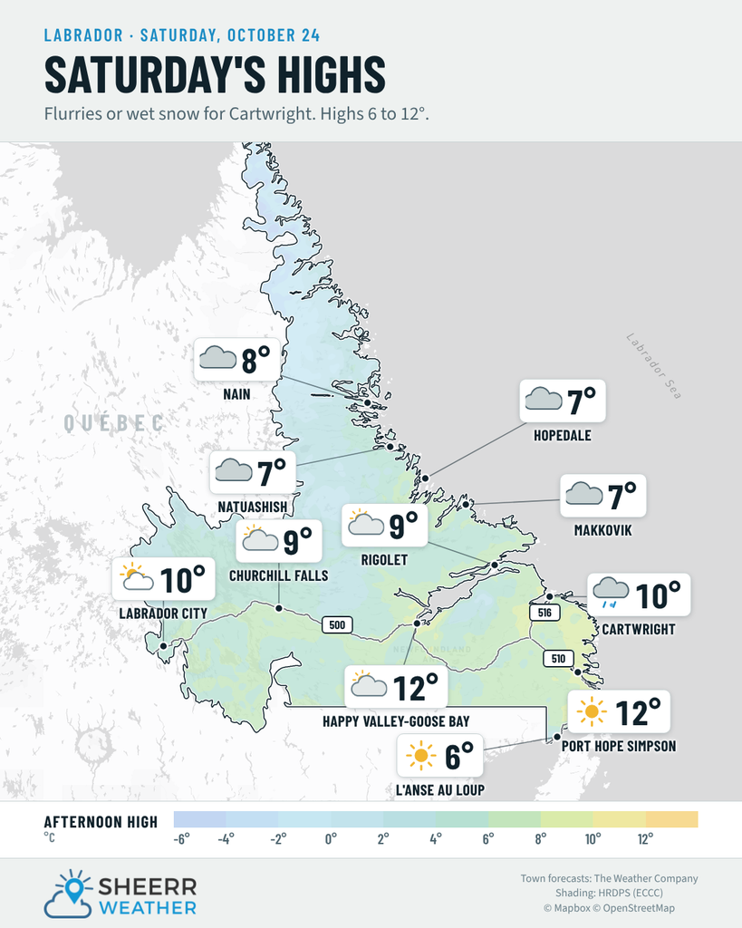
Labrador / the Big Land: A mix of sun and cloud in Lab West, with a high near 10, and 8 in Churchill Falls. Partly cloudy this morning in Goose Bay, becoming cloudy this afternoon, with a high near 12. Overcast in Nain, with a high near 7, and windy this morning in Hopedale and Makkovik, with west winds 30 to 50 km/h. Periods of freezing drizzle around Cartwright and Black Tickle this morning, then becoming partly cloudy, with a high near 10. Sunny from Eagle River to Lodge Bay, with highs of 10 to 11, and 6 in the Labrador Straits. Lows of minus 2 to 3 tonight.
Looking ahead: Sunday is a much nicer day across the Island, with a mix of sun and cloud and highs of 9 to 14. It warms up Monday, with highs of 13 to 14 in the east, though a few showers are possible on the West Coast Monday morning. In Labrador, clouds and some rain move into Lab West and Churchill Falls on Sunday, with snow changing to rain in Nain, and it turns colder in Lab West on Monday, with a few snow showers and a high near 1. There are no major weather events in the forecast for now.
📱 Get the Sheerr Weather App in the Apple App Store and Google Play Store.
📍 Want more detail for where you live? Check out our new Regional Forecast pages for current conditions, local alerts, highway cams and the forecast for your area: Avalon · Eastern · Burin Peninsula · South Coast · West Coast · Long Range Mountains · Central · GNP & the Straits · Labrador West · Central Labrador · Labrador North Coast · Labrador South Coast
🗺️ Check out the Map Room to see all the latest weather observations for the Province.
🎥 Check out the Provincial Highway Cams to see 👀 what’s going on around our highways.
thanks Eddie