
Friday Morning’s Weather Briefing — October 23, 2026
Good Friday Morning!
- Josephine became a powerful post-tropical storm last evening and passes well south of Newfoundland today, but it still brings us rain, wind and our first snow of the season.
- A Wind Warning is in effect for the south coast from Burgeo to the Burin Peninsula and the southern Avalon, with northeasterly gusts of 80 km/h, except 100 along parts of the coast, this afternoon and evening.
- Rain today, with 10 to 20 mm on the Avalon, 5 to 10 mm on the Burin Peninsula and South Coast, and much less to the north and west. It ends late this evening.
- A Special Weather Statement is out for about 2 cm of snow over higher terrain from Burgeo to the Burin Peninsula and around Clarenville this morning into the afternoon, so watch for slushy highways.
- In Labrador, a cold start a few degrees below freezing, then sunshine and highs of 3 to 5, with a mild weekend on the way.
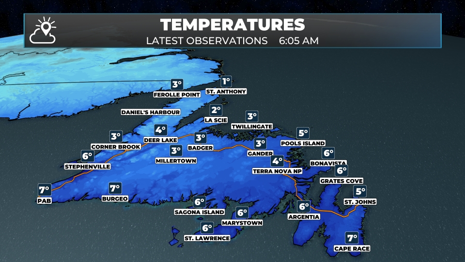
It’s a raw start to the day across much of Newfoundland. Just after 6 AM, it was 4.5º with light rain in St. John’s, 4 in Clarenville, 3 in Gander and Corner Brook, and that’s about as warm as it gets today. Temperatures will hold steady or slowly fall through the day, and with a gusty northeast wind, it’ll feel more like November than October.
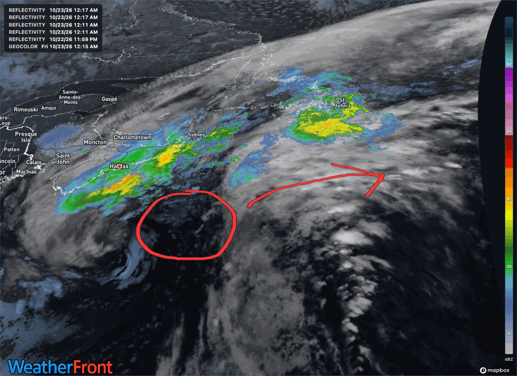
Josephine’s journey as a tropical system is over. The National Hurricane Center issued its final advisory at 5 PM yesterday, after Josephine became a powerful post-tropical low about 540 km south-southwest of Halifax, with winds near 100 km/h. It continues northeast today and passes well south of Newfoundland tonight before heading out to sea. As it does, it’s pulling colder air down over the Island from the north, and that sets up a messy mix of rain, wind and even a little snow for southern and eastern Newfoundland today.
Rain is already falling on the Avalon this morning and continues through the day, with 10 to 20 mm for St. John’s and Placentia. The Burin Peninsula and South Coast look to see 5 to 10 mm, while Clarenville and the Bonavista Peninsula get 2 to 4 mm. Central and western Newfoundland stay mostly dry, with just a few rain showers or flurries. The rain winds down late this evening.
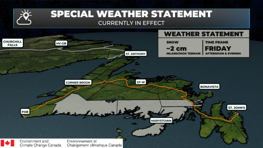
Environment Canada has issued a Special Weather Statement for the first notable accumulating snowfall of the season, primarily over higher terrain, along the south coast of Newfoundland from Burgeo to the Burin Peninsula as well as Clarenville and vicinity. About 2 cm is expected, highest over higher terrain, this morning until this afternoon. With temperatures hovering near the freezing mark, amounts may vary over short distances, and it should stay mostly rain along the coast. Be prepared for winter driving conditions, particularly over higher terrain sections of the Bay d’Espoir Highway, Burin Peninsula Highway, Burgeo Highway, and the Trans-Canada Highway between Goobies and Port Blandford. Give yourself a few extra minutes if you’re heading out on any of those roads today.
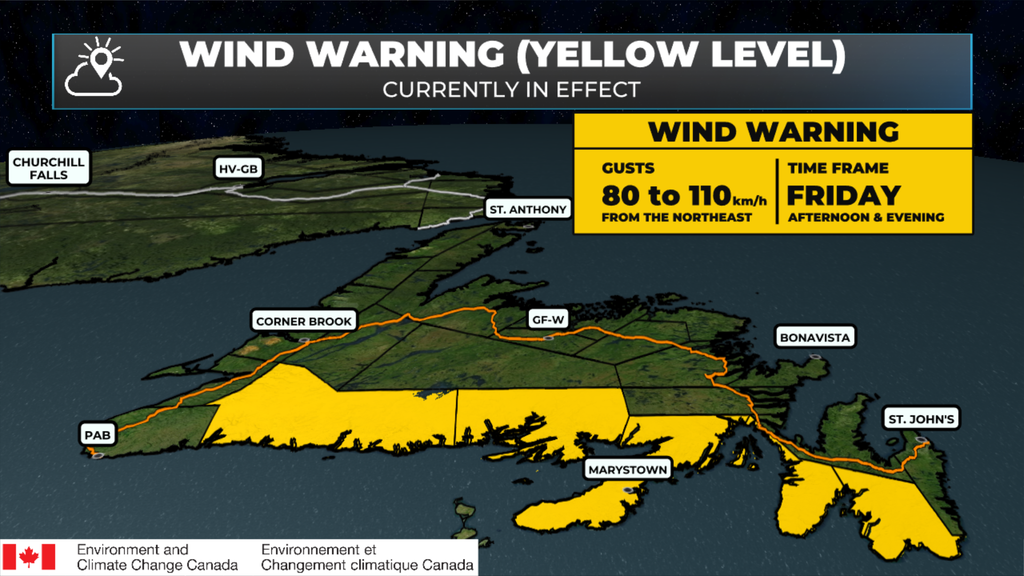
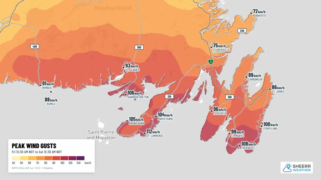
The wind is the other big story. A Wind Warning is in effect for the south coast of Newfoundland from Burgeo to the Burin Peninsula, and the southern Avalon Peninsula, with maximum wind gusts northeasterly 80 km/h, except 100 along parts of the coast, this afternoon and evening. Local utility outages are possible, along with disruptions to services and travel. Elsewhere on the east coast, including St. John’s, Clarenville and Bonavista, northeast winds gusting to 70 are expected. Heavy surf continues along south-facing coastlines too, so keep well back from the water.
Meanwhile in Labrador, it’s a cold but bright start, with temperatures a few degrees below freezing and wind chills near minus 8 to minus 10 this morning. Skies clear out today, with highs of 3 to 5 under mostly sunny skies.
Eastern Newfoundland / the Avalon: Rain, with fog patches dissipating this morning. 10 to 20 mm on the Avalon. Northeast winds 20 km/h gusting to 40, increasing to 40 gusting to 70 this morning, and gusting near 100 along parts of the southern Avalon coast this afternoon and evening under the Wind Warning. Temperatures falling to 3 this afternoon. Periods of rain for Clarenville and the Bonavista Peninsula, with 2 to 4 mm and about 2 cm of snow over higher terrain around Clarenville this morning. Rain ends late this evening, then cloudy with a chance of showers, northeast winds gusting to 70, and temperatures near 1 to 3 overnight.
Central: A few rain showers ending this morning in Gander, then mainly cloudy with a 40 to 60 percent chance of rain showers or flurries. Fog patches dissipating this morning. Northeast winds 30 km/h gusting to 60. Temperatures steady near 4. Mainly cloudy tonight, with lows near the freezing mark.
West Coast: Mainly cloudy, with a 40 percent chance of rain showers or flurries this morning in Deer Lake. Northeast winds 30 to 40 km/h, gusting to 60. Temperatures steady near 3 to 4. Mainly cloudy tonight, with lows near 1. Saturday clears out in the morning, with highs of 6 to 7.
South Coast: Rain on the Burin Peninsula and along the coast, with snow over higher terrain. 5 to 10 mm of rain and about 2 cm of snow over higher terrain. Northeast winds 40 km/h gusting to 60, increasing to 60 gusting to 80, except gusting to 100 along parts of the coast this afternoon, under the Wind Warning. Temperatures falling to 3 this afternoon, near the freezing mark inland and over higher terrain. A few showers end near midnight, with northeast winds still gusting to 80 or 100 along the coast this evening. In Burgeo, periods of rain, with periods of snow over the higher terrain along the Burgeo Highway.
Southwest / Wreckhouse: Cloudy, with a 60 percent chance of showers and a high near 5 in Port aux Basques. Northeast winds 20 km/h gusting to 40, increasing to 40 gusting to 60 this morning, then north 30 gusting to 60 tonight. Northeast and north winds don’t usually cause trouble at Wreckhouse, but you can always check the Wreckhouse Wind Gauge before you travel.
GNP and the Straits: Cloudy, becoming a mix of sun and cloud this afternoon in St. Anthony, with a high near 5. North winds 30 km/h gusting to 50, becoming northeast 20 gusting to 40 this afternoon. Clearing this evening, with a low near minus 1. Sunny Saturday, with a high near 7.
Labrador / the Big Land: Clearing this morning in Lab West and Churchill Falls, with highs of 3 to 5 and wind chills near minus 9 this morning. Mainly sunny in Goose Bay, with a high near 5. A mix of sun and cloud along the southeast coast, with a 40 percent chance of flurries this morning, then sunny this afternoon, with highs near 4. Mainly sunny in Nain, with a high near 3. Clear to partly cloudy tonight, with lows of minus 1 to minus 5. Sunny and milder Saturday, with highs of 7 to 10.
Looking ahead: Josephine heads out to sea tonight, but Saturday stays cool, cloudy and breezy in the east, with a few showers on the Avalon (2 to 4 mm), northeast winds gusting to 60 and a high near 5. If you’re running the ECT50 on the East Coast Trail on Saturday, plan for a cool, damp and breezy day. Central and western Newfoundland clear out Saturday, and the whole province looks better Sunday, with temperatures back into the teens by Monday before cooling off again Tuesday. Labrador stays sunny and turns milder, with highs near 9 to 10 this weekend.
📱 Get the Sheerr Weather App in the Apple App Store and Google Play Store.
📍 Want more detail for where you live? Check out our new Regional Forecast pages for current conditions, local alerts, highway cams and the forecast for your area: Avalon · Eastern · Burin Peninsula · South Coast · West Coast · Long Range Mountains · Central · GNP & the Straits · Labrador West · Central Labrador · Labrador North Coast · Labrador South Coast
🗺️ Check out the Map Room to see all the latest weather observations for the Province.
🎥 Check out the Provincial Highway Cams to see 👀 what’s going on around our highways.
thanks Eddie