
Thursday Morning’s Weather Briefing — October 22, 2026
Good Thursday Morning!
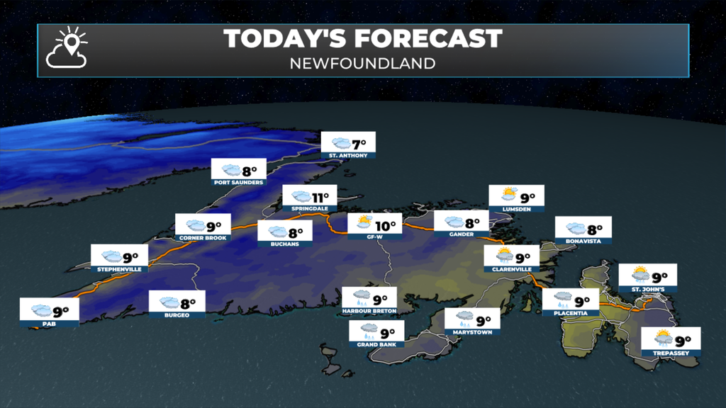
- Fog patches this morning, then a mainly cloudy, mild day across Newfoundland, with highs of 8 to 10.
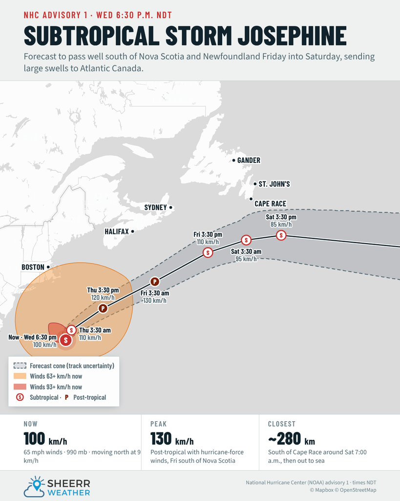
- The low we’ve been watching all week is now Subtropical Storm Josephine. It will pass well south of Newfoundland, about 280 km south of Cape Race early Saturday, but along with another system dropping in from the west, it brings us rain, wind and big swells from late today into Saturday.
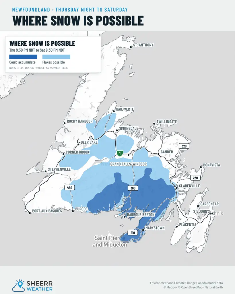
- Rain moves in this afternoon and tonight, with the heaviest on the Burin Peninsula and South Coast (20 to 30 mm) and 10 to 20 mm on the Avalon, plus wet snow possible over higher terrain on the Burin Peninsula and in central Newfoundland on Friday.
- A raw northeast wind kicks in Friday and Saturday, gusting near 60 km/h on the east coast, and heavy surf and dangerous rip currents build along the South Coast, Burin and southern Avalon.
- In Labrador, rain showers and flurries today, with temperatures steady near 1 to 2 in the west, then clearing and cold tonight before a sunny Friday.
Today is the calm before the storm, at least for most of Newfoundland. There are some fog patches around this morning, so take it easy if you’re on the road early. They thin out through the morning, leaving a mainly cloudy and fairly mild day, with highs of 8 to 10.
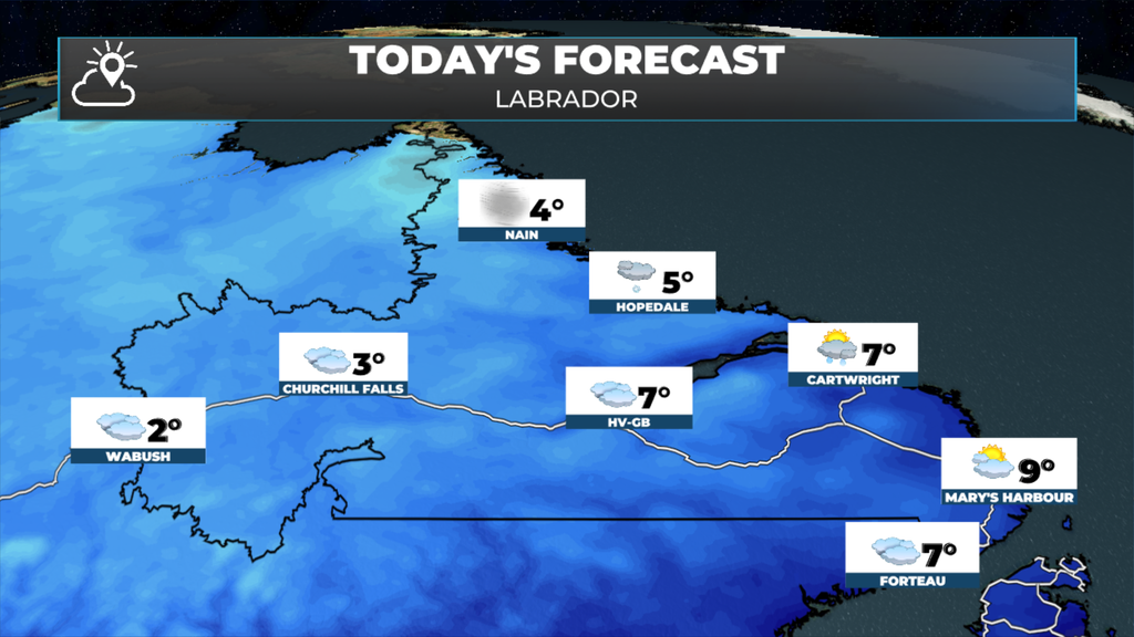
Meanwhile in Labrador, we can expect cloudy to mostly cloudy skies with scattered showers and flurries today. The coolest readings will be in the north and west, with highs near 3º, while eastern and southern areas will get closer to 8º this afternoon.
The low we’ve been watching off the U.S. East Coast all week officially became Subtropical Storm Josephine last evening, with winds near 100 km/h and a wind field stretching more than 600 km from the centre. The National Hurricane Center expects it to speed up and head northeast today, strengthen into a post-tropical storm with hurricane-force winds south of Nova Scotia on Friday, then pass well south of Newfoundland, about 280 km south of Cape Race early Saturday morning, before heading out to sea. It won’t bring direct impacts here, but the weather from late today into Saturday will come partly from Josephine and partly from another system dropping in from the west. Rain begins on the Burin Peninsula around noon and reaches the Avalon this afternoon, with about 5 to 10 mm by this evening. It spreads into Clarenville and the Bonavista Peninsula this evening, and showers reach central Newfoundland and the West Coast overnight. On Friday, northerly winds will drag in colder air, and that’s where things get tricky.
Rain falls tonight and Friday, with the heaviest on the Burin Peninsula and South Coast, where 20 to 30 mm is possible by Saturday. The Avalon looks to see 10 to 20 mm, with much less as you head west. With that colder air working in, wet snow is possible Friday, especially Friday afternoon, on the Burin Peninsula and through the interior of southern and central Newfoundland. Places right along the coast will most likely stay as rain, but inland and over higher terrain, like the Burin Peninsula Highway south of Swift Current, could very well see snow. How much snow, and exactly where, is still hard to pin down, and it all depends on the track of the low.
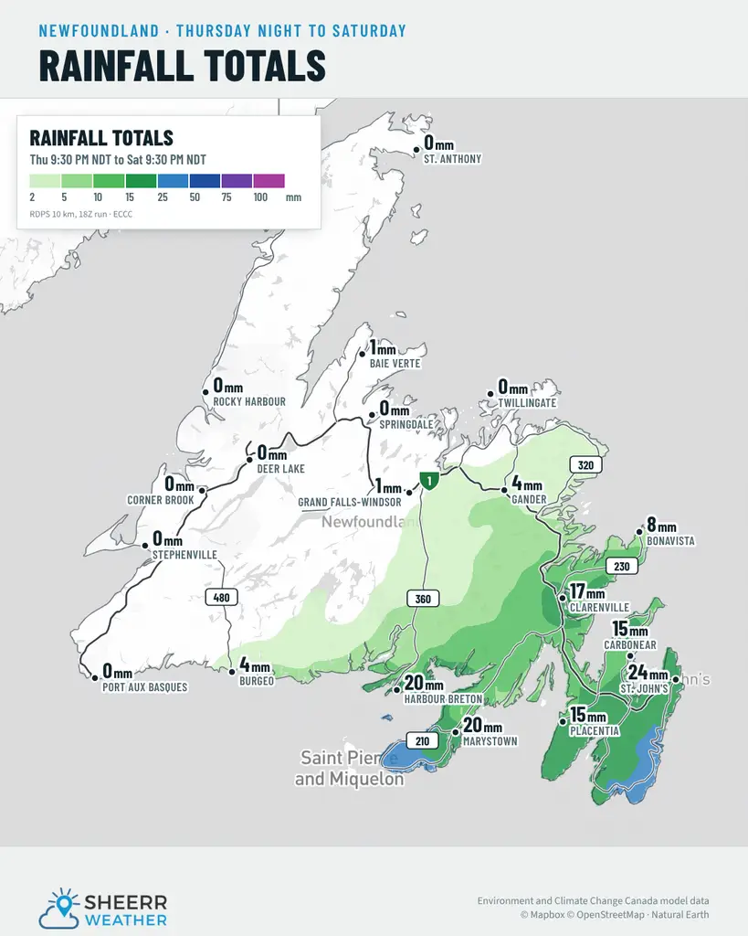
A raw northeast wind kicks in Friday and Saturday, sustained at 40 to 45 km/h and gusting near 60 on the east coast, with temperatures stuck in the mid single digits. Josephine is also already sending swells our way. Starting today, they’ll build along the South Coast, the Burin Peninsula and the southern Avalon, with heavy surf and dangerous rip currents into the weekend, so keep well back from the water’s edge.
Eastern Newfoundland / the Avalon: Fog patches early, then mainly cloudy, with a high near 10 and south winds 20 km/h. Periods of rain begin on the Avalon this afternoon, with about 5 mm by evening, and spread to Clarenville and the Bonavista Peninsula this evening. Rain tonight, with 10 to 20 mm and fog patches, and northeast winds gusting to 40 overnight. Lows of 3 to 5. Windy with showers or rain Friday, with northeast winds gusting near 60 and a high near 4. Heavy surf and dangerous rip currents are possible along the southern Avalon into the weekend.
Central: Fog patches early, then mainly cloudy, with highs near 9 to 10. Southwest winds 20 km/h, gusting to 40, becoming light this afternoon. Showers begin near midnight, with north winds gusting to 40 overnight. Lows near +2 to +3. Rain showers or flurries Friday, with highs of only 3 to 4, and wet snow possible inland and over higher terrain.
West Coast: Fog patches early, then mainly cloudy, with a 40 percent chance of showers or drizzle and highs of 9 to 10. A 60 percent chance of showers tonight, with lows near +2. Friday is cloudy, with a chance of rain showers or flurries and highs near 3, and the West Coast looks to see the least rain from this system.
South Coast: Fog patches early, then mainly cloudy, with highs of 8 to 9. Periods of rain begin on the Burin Peninsula near noon, with 5 to 10 mm, and continue tonight, with fog patches. Totals of 20 to 30 mm are possible on the Burin Peninsula and South Coast by Saturday. Showers or drizzle are possible toward Burgeo, with rain beginning overnight. Friday brings periods of rain, windy conditions and a high near 6, with wet snow possible over higher terrain on the Burin Peninsula. Swells from Subtropical Storm Josephine build along the South Coast and Burin starting today, with heavy surf and dangerous rip currents into the weekend, so keep well back from the water’s edge.
Southwest / Wreckhouse: Cloudy, with a 40 percent chance of showers or drizzle and a high near 8 in Port aux Basques. Southeast winds 20 km/h, gusting to 40, go light this afternoon. Tonight, a 40 percent chance of showers, with winds turning north overnight and a low near 6. Friday brings showers and windy conditions, with a high near 6. North and northeast winds don’t usually cause trouble at Wreckhouse, but you can always check the Wreckhouse Wind Gauge before you travel.
GNP and the Straits: Mainly cloudy, with southwest winds 30 to 40 km/h, gusting to 50 or 60, this morning, becoming west 20 near noon. Highs of 7 to 8. Mainly cloudy tonight, with winds turning north 30 km/h, gusting to 50, near midnight, and lows near +2. Friday is cloudy and windy, with a 40 percent chance of rain showers or flurries and highs near 3.
Labrador / the Big Land: Lab West is mainly cloudy, with a 60 percent chance of flurries and temperatures steady near 1. Churchill Falls sees rain showers or flurries, with temperatures steady near 2. In Goose Bay, a few showers end this morning, then a 40 percent chance of showers and a high near 8. Along the southeast coast, a 40 percent chance of showers, with highs of 7 to 9 and temperatures falling this afternoon as winds turn west. On the North Coast, a few rain showers or flurries begin this morning in Nain, with north winds gusting to 60 this afternoon. Clearing and cold tonight, with lows of -3 to -6 and wind chills near -9 to -12. Friday is sunny across most of Labrador, with highs of 2 to 5.
Looking ahead: Friday is the main event for Newfoundland, with rain, a raw northeast wind and possibly wet snow over higher terrain, especially in the south and east. Josephine passes about 280 km south of Cape Race early Saturday and heads out to sea. The rain winds down Saturday morning, but the northeast wind, drizzle and showers could linger in eastern Newfoundland, with temperatures stuck in the mid single digits, and heavy surf continues along southern coastlines into the weekend. If you’re running the ECT50 on the East Coast Trail on Saturday, plan for a cool, damp and breezy day. Labrador stays quiet and turns milder, with highs near 9 to 11 by Saturday.
📱 Get the Sheerr Weather App in the Apple App Store and Google Play Store.
📍 Want more detail for where you live? Check out our new Regional Forecast pages for current conditions, local alerts, highway cams and the forecast for your area: Avalon · Eastern · Burin Peninsula · South Coast · West Coast · Long Range Mountains · Central · GNP & the Straits · Labrador West · Central Labrador · Labrador North Coast · Labrador South Coast
🗺️ Check out the Map Room to see all the latest weather observations for the Province.
🎥 Check out the Provincial Highway Cams to see 👀 what’s going on around our highways.