
Thursday Morning’s Weather Briefing — October 15, 2026
Good Thursday Morning!
Rain and wind are the story this morning across eastern and central Newfoundland, with mild temperatures in the upper single digits to lower teens.
A wind warning remains in effect for St. John’s, the northern Avalon and the Bonavista Peninsula, with gusts of 80 km/h and up to 100 along parts of the coast, ending near noon.
The Wreckhouse wind warning has ended, but not before the winds there gusted to 110 km/h just after midnight.
Winds swing around to the northwest this afternoon and tonight as the low pulls away, and it turns cooler, especially in the west.
Snow showers for Lab West this morning, and rain for southeastern Labrador.
Friday is the break before another storm arrives Saturday, with rain and wind for the Island and snow for parts of Labrador.
It was a noisy night in a lot of places. The area of low pressure that brought rain to the Island overnight is moving across Newfoundland this morning, and it’s a mild, wet and windy start for the east, with temperatures of 9 to 13 and rain falling heavily at times, especially in the east. Radar (loop below) shows that as of just before 6 AM, that’s where the heaviest rain was located. If you’re heading out early, give yourself a few extra minutes, watch for water pooling on the roads, and be ready for some strong gusts.
Wind warning for the Avalon and Bonavista Peninsula: Environment Canada’s wind warning continues for the northern Avalon Peninsula, St. John’s and vicinity, and the Bonavista Peninsula. Damaging south to southeasterly winds are occurring, with maximum gusts of 80 km/h, except 100 along parts of the coast, ending near noon. Local utility outages are possible, so secure any loose objects if you haven’t already.
Wreckhouse: The Wreckhouse wind warning has ended. The winds lived up to the forecast overnight, with Environment Canada’s Wreckhouse station recording a peak gust of 110 km/h at about 12:40 this morning. You can follow the winds there any time on my new Wreckhouse Wind Gauge, with live gusts, a 24-hour forecast, alerts and road info all in one place.
As the low pulls away to the northeast this afternoon, the winds swing around to the west-northwest and stay gusty, especially on the Northern Peninsula, the West Coast and the Bonavista Peninsula, where gusts over 65 km/h are possible into tonight. High wind speeds will also return to the Wreckhouse area and southwestern Newfoundland, where forecasts indicate westerly gusts as high as 100 km/h are possible. This may requre another wind warning from Environment Canada. The rain tapers to showers in the east this afternoon, but it becomes steadier in Central and continues on and off in the west, where it’s a much cooler day, with highs of just 6 or 7.
This morning’s update is sponsored by Roebothan, McKay, Marshall.
Visit MakeTheCall.ca today to learn more about how the law firm can help you!
Eastern Newfoundland / the Avalon: Windy with rain this morning, heavy at times, tapering to showers this afternoon. Highs 14 to 15. Southerly winds 40 to 55 km/h, and a wind warning is in effect for St. John’s, the northern Avalon and the Bonavista Peninsula until near noon, with gusts of 80 km/h and up to 100 along parts of the coast. About 12 mm of rain today. Periods of rain tonight, with another 5 mm or so, and winds shifting to the west-northwest at 40 to 55 km/h, gusting over 65. Lows near 4.
Central: Showers this morning, becoming a steady rain this afternoon. Highs near 10 in Grand Falls-Windsor and 13 to 14 from Gander to Clarenville. Southeasterly winds shift to the west-northwest this afternoon at 30 to 50 km/h around Gander. Rain ends this evening, with lows of 1 to 3.
West Coast: Periods of rain and a cool day, with highs near 7 in Corner Brook and Deer Lake, 6 in Gros Morne and 10 in Stephenville. Northerly winds pick up this afternoon to 30 to 50 km/h, gusting over 65 from Stephenville to Gros Morne. About 6 to 12 mm of rain. A few showers this evening, then lows of 2 to 4.
South Coast: Cloudy and windy with rain, soaking at times this afternoon. Highs 11 to 13. West to southwest winds 30 to 50 km/h, gusting over 65. Rain ends this evening and skies clear overnight, with northwesterly winds staying gusty. Lows near 3 or 4.
Southwest / Wreckhouse: The Wreckhouse wind warning has ended after gusts to 110 km/h overnight. Today is cloudy and windy with periods of rain, and a high near 11 in Port aux Basques. Northwest winds 40 to 55 km/h, gusting over 80 at times, continue into tonight. Lows near 4.
GNP and the Straits: Rain, about 12 mm, and becoming windy this afternoon. Highs 6 to 7. North to northeasterly winds increase to 40 to 55 km/h, gusting over 65. Windy tonight, with gusts near 80 around Port au Choix and lows of 1 to 3.
Labrador: Lab West has scattered snow showers this morning, then a mix of sun and cloud, with a high near 2 and gusty northwest winds. Churchill Falls is cloudy, with a high near 4 and the chance of a shower of rain or wet snow. Goose Bay has a few showers early, then cloud, with a high near 8. On the South Coast, rain, with about 12 mm around Mary’s Harbour, highs of 4 to 5, and north winds gusting over 65 this afternoon and tonight, with a few flurries possible around Cartwright tonight. On the North Coast, a mix of sun and cloud with gusty west winds, and a high near 6 in Nain. Lows tonight are below freezing for most of Labrador, down to -5 in Lab West.
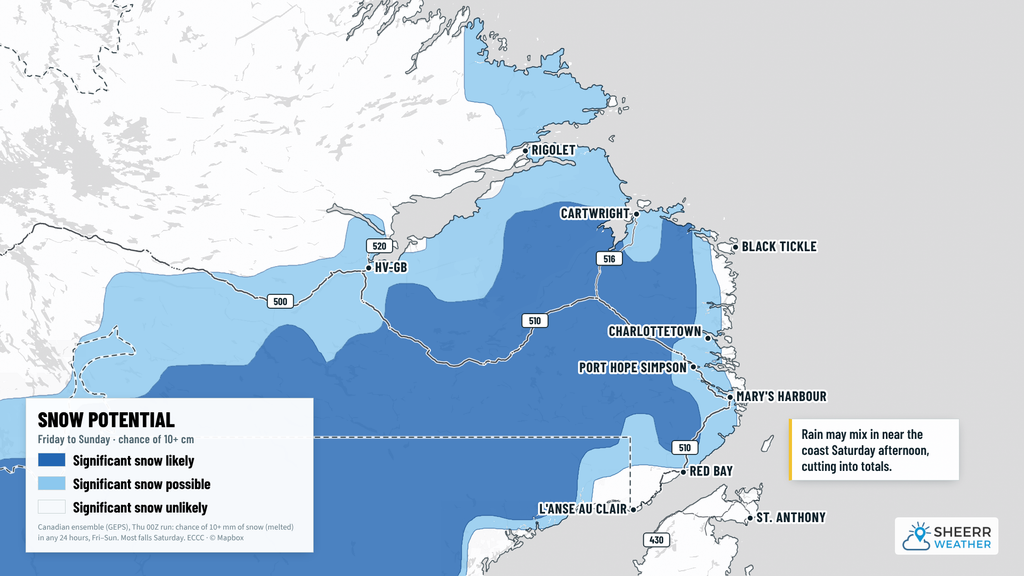
Looking ahead: Friday is the break between systems. It stays cloudy and windy in the east, with west-northwest gusts over 65 km/h at times and a high near 8 in St. John’s, while the rest of the Island sees more in the way of sun, with highs of 5 to 9. Our next storm arrives Saturday, intensifying rapidly as it passes near the Province. It brings rain and strong southwesterly winds to the Island, along with a mild day in the east, with highs of 15 to 17. In Labrador, snow moves into Lab West Friday night, with 3 to 7 cm possible, and Goose Bay and Cartwright could see 3 to 7 cm on Saturday. Right along the southeastern coast, from L’Anse au Loup to Mary’s Harbour, the latest guidance shows snow changing to rain on Saturday. Small changes in the track of this low will make a big difference, so I’ll keep a close eye on it for you.
📱 Get the Sheerr Weather App in the Apple App Store and Google Play Store.
🗺️ Check out the Map Room to see all the latest weather observations for the Province.
🎥 Check out the Provincial Highway Cams to see 👀 what’s going on around our highways.