
Wednesday Morning’s Weather Briefing — October 14, 2026
Good Wednesday Morning!
It’s a frosty start in many areas, with temperatures a few degrees below zero inland and down to -7 in Labrador West.
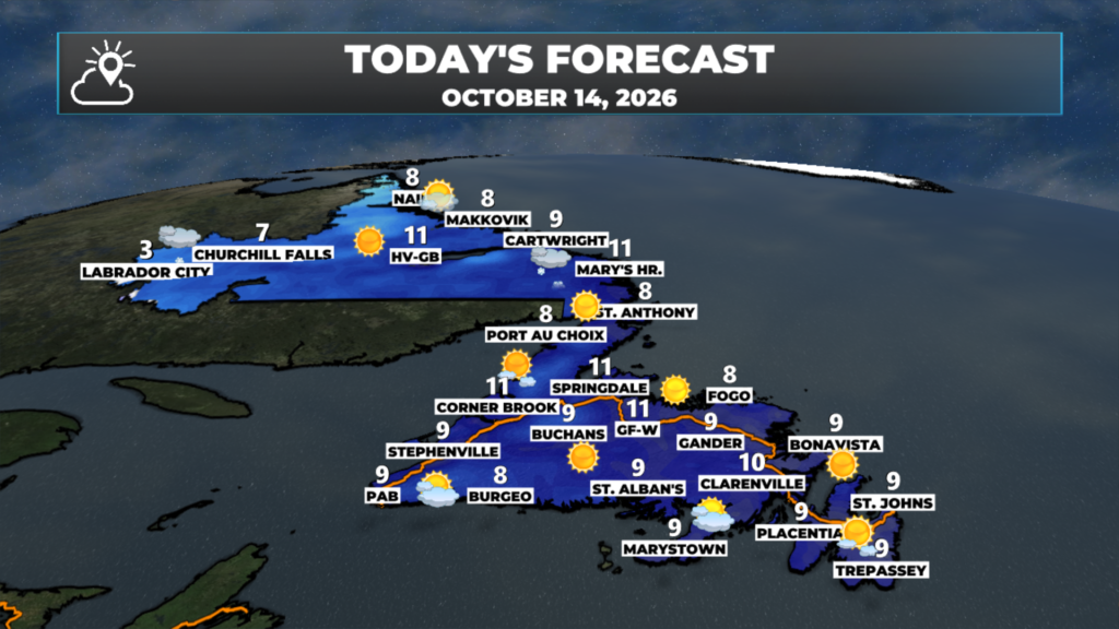
High pressure gives the Island a sunny, milder day, with highs climbing to 9 to 11 for most areas.
Our next system arrives from the southwest this afternoon and evening, with rain spreading across the Island tonight and continuing Thursday.
A Wreckhouse wind warning is in effect, with southeasterly gusts up to 100 km/h this evening until after midnight.
A wind warning is also in effect for the northern Avalon, St. John’s and the Bonavista Peninsula for Thursday morning, with gusts of 80 km/h and up to 100 along parts of the coast.
Snow showers move into Lab West this afternoon, and a much more potent storm is lining up for Friday night into Saturday.
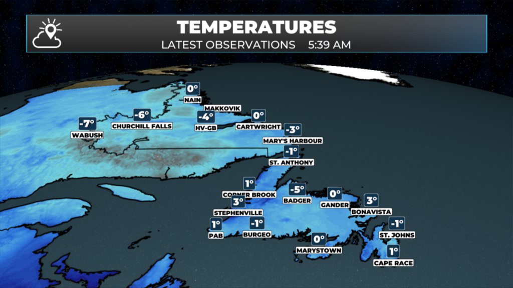
Enjoy the first half of today, because it’s a nice one. High pressure is sliding off to the east this morning, and that gives most of the Province a sunny and milder day after a frosty start. Grand Falls-Windsor is near -4 this morning, Clarenville and Springdale are a couple of degrees below zero, and Labrador West is down around -7, so scrape the windshield and give yourself a few extra minutes.
This afternoon, things start to change in the southwest. Clouds thicken and southeasterly winds pick up as the next area of low pressure approaches from the Maritimes. Rain reaches Port aux Basques and the Southwest Coast around suppertime, spreads along the South Coast and into the west this evening, and moves across Central and the Avalon after midnight.
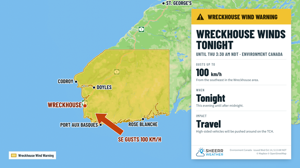
Wreckhouse wind warning: Environment Canada has a Wreckhouse wind warning in effect, with southeasterly gusts up to 100 km/h in the Wreckhouse area this evening until after midnight. Winds start ramping up this afternoon and peak this evening before slackening off overnight. Driving conditions will likely be difficult, and high-sided vehicles will be pushed around by the wind, so plan accordingly if you’re travelling through the area tonight.
The heaviest rain tonight falls along the South Coast, where 25 to 30 mm is possible from Burgeo to Harbour Breton and the Burin Peninsula. Most other areas of the Island see around 10 to 15 mm by Thursday morning.
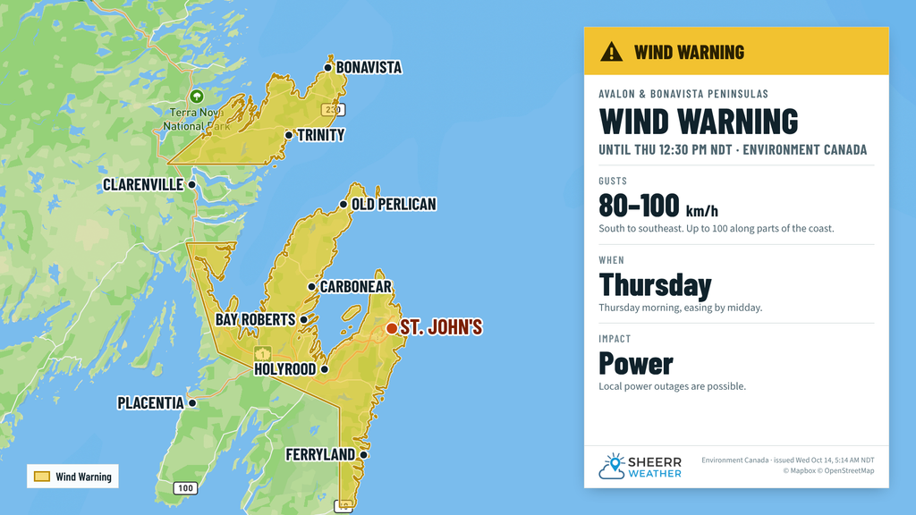
Wind warning for the Avalon and Bonavista Peninsula: Environment Canada has also issued a wind warning for the northern Avalon Peninsula, St. John’s and vicinity, and the Bonavista Peninsula for Thursday morning. As the rain moves in overnight, south to southeasterly winds ramp up, with gusts of 80 km/h expected and up to 100 km/h along parts of the coast. Local utility outages are possible, so take a few minutes this evening to secure loose objects like garbage bins, patio furniture and any outdoor decorations before the wind picks up.
This morning’s update is sponsored by Roebothan, McKay, Marshall.
Visit MakeTheCall.ca today to learn more about how the law firm can help you!
Eastern Newfoundland / the Avalon: Sunny and milder, highs 10 to 11, with a light west to southwest wind. Rain arrives after midnight and becomes heavy at times toward morning. Southerly winds increase overnight, and a wind warning is in effect for the northern Avalon, St. John’s and the Bonavista Peninsula for Thursday morning, with gusts of 80 km/h and up to 100 along parts of the coast. Temperatures rise overnight, to 6 to 8 by morning.
Central: A frosty start, then sunny, with highs 10 to 11. Rain moves in late this evening, with about 10 mm by Thursday morning. Southeasterly winds gust 40 to 55 km/h overnight, a little stronger toward Gander and the Northeast Coast. Lows near 3, rising overnight.
West Coast: Mostly sunny this morning and early afternoon, with highs 10 to 11 in Corner Brook and Deer Lake, and near 8 in Gros Morne. Rain arrives this evening, with 10 to 15 mm overnight. Lows near 5 or 6.
South Coast: Clouding over this morning, with highs near 9. Rain arrives this evening and is heavy at times overnight, with 25 to 30 mm from Burgeo to the Burin Peninsula. Southeasterly winds gust 50 to 65 km/h tonight. Temperatures hold near 7 to 8.
Southwest / Wreckhouse: Sun and cloud this morning, highs near 9, then rain developing late in the afternoon. A Wreckhouse wind warning is in effect, with southeasterly gusts up to 100 km/h in the Wreckhouse area this evening until after midnight. Gusts near 70 around Port aux Basques. About 15 to 20 mm of rain by Thursday morning.
GNP and the Straits: Partly cloudy and breezy from the west-southwest, with highs 8 to 9. Rain arrives late tonight, and Thursday turns wet and windy, with northeasterly winds gusting into the 40s and 50s.
Labrador / the Big Land: Lab West climbs from a frosty -7 to a high near 3, with snow showers this afternoon and evening and a centimetre or two possible by morning. Churchill Falls reaches about 6, with rain and snow tonight. Goose Bay is sunny with a high near 11, with a few showers late tonight. The South Coast is sunny, with highs 7 to 11, then rain late tonight that continues through Thursday. The North Coast is mostly sunny, with a high near 8 in Nain.
Looking ahead: Rain and wind continue Thursday, with highs 11 to 14 in the east, while the west cools down to 7 to 9 as the winds turn northwest behind the low. Southeastern Labrador sees 15 to 20 mm of rain on Thursday, mixing with some snow at times. Things quiet down Thursday night and Friday, but not for long. A much more potent storm is lining up for Friday night into Saturday. It’s expected to intensify very quickly as it moves northeast of Newfoundland, bringing high winds, heavy rain, and the potential for heavy snowfall in parts of southeastern Labrador. I’ll have more on that later today.
📱 Get the Sheerr Weather App in the Apple App Store and Google Play Store.
🗺️ Check out the Map Room to see all the latest weather observations for the Province.
🎥 Check out the Provincial Highway Cams to see 👀 what’s going on around our highways.
Thanks Eddie
Good Morning Eddie! Thanks for update. It looks like we’re in for a few nasty days….. that wind!!!!
Have a good day!