
Tuesday Morning Update — February 3,
Good Monday Morning!
Here are today’s weather highlights:
Our winter storm has departed and dropped heavy snow over much of eastern and parts of central Newfoundland. As of late last night, St. John’s International Airport’s weather observer had measured 44 cm of snow. Other weather observers around the Metro regions measured similar totals. I’ll have a full rundown of snowfall amounts when that becomes available.
Light flurries do remain in some areas this morning, and I do suspect there will be delayed openings for many things.
Gov NL offices open at 10:30 this morning.
Coastal flooding is also a concern today, and Yellow Level Coastal Flood Warnings are in effect for much of the Island from Cape Feels eastward to the Avalon Peninsula and then westward to the Burin Peninsula, specifically the eastern side. This will remain in effect through the morning high tide cycle, which starts around 9 AM and ends around 11 AM. Wave heights will be 4 to 6 metres.
A combination of storm surge coinciding with high tide will push water beyond its usual reach, exceeding the highest astronomical tide.
Roads and walkways may be difficult to navigate due to flooding and/or debris, such as driftwood and rocks. Properties in coastal locations will likely be affected by spray and wave overtopping.
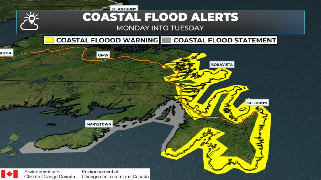
Coastal Flood Alerts as of February 3, 2026 at 6 AM
It’s breezy across parts of the Province this morning, but not as windy as it was last night when many areas in the eastern and northeastern parts of Newfoundland had gusts nearing 100+ km/h.
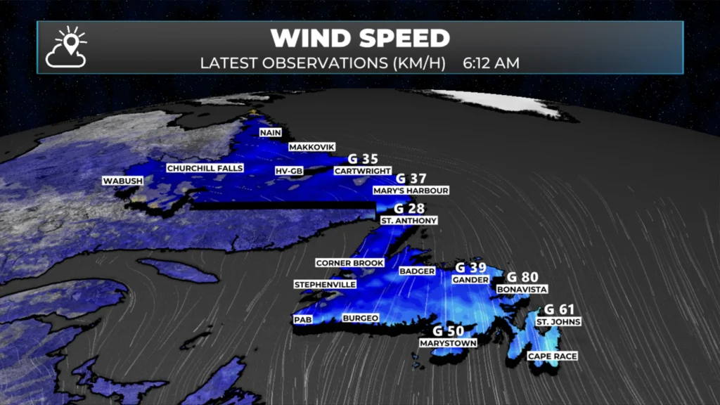
Observed wind gusts as of 6:12 AM NST
Outside of that, the weather across the Province today will be much calmer than yesterday, and this is the shortest morning blog I’ve been able to write in a long time. Expect partly to mosly cloudy skies on the Island today, with highs near freezing. Wind speeds will be much, much lower than yesterday and last night.
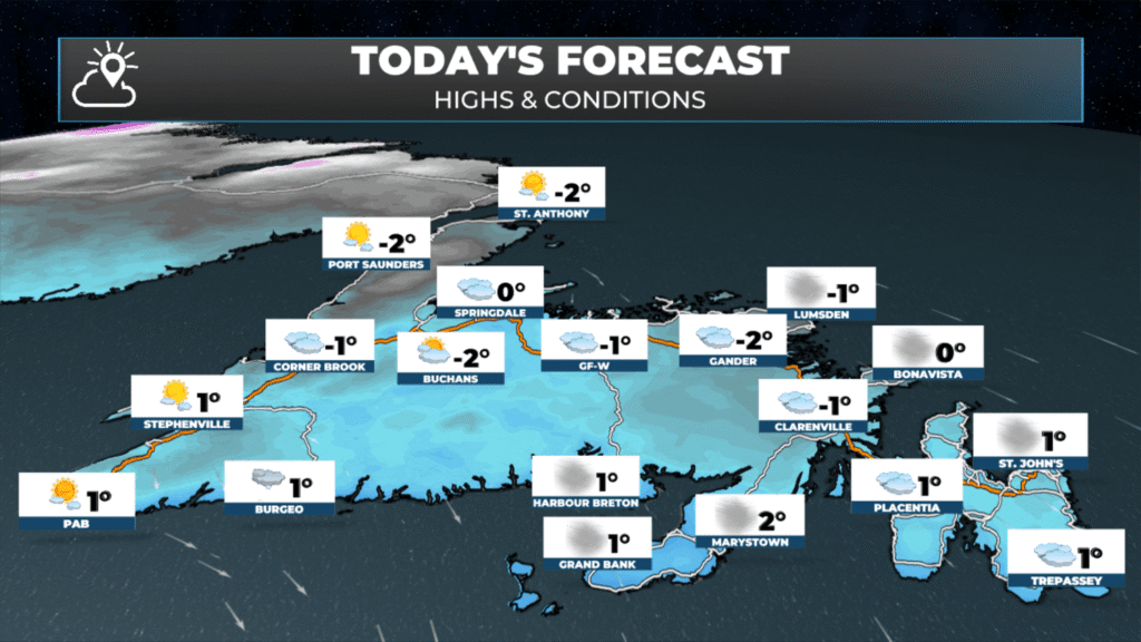
Newfoundland’s forecast for today – February 3, 2026.
Labrador will see highs today ranging from the minus teens to single digits, under mostly sunny skies. Overall, the nicest day the Big Land has had in quite a while!
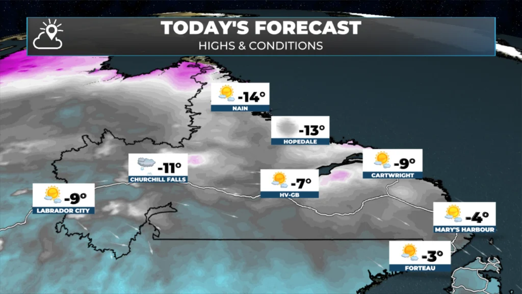
Labrador’s forecast for today — February 3, 2026
The next chance of any weather looks to be Thursday and Friday when flurries and pockets of light snow return to the Island. That system did look a bit more potent yesterday, but trends have been for a more southern track, keeping much of the significant snow offshore. That said, even pockets of flurries can be difficult to nail down locally. I’ll focus on that more today… in the meantime I must go clean up the driveway!
I’ll have updates for you throughout the day!
📱 Get the Sheerr Weather App in the Apple App Store and Google Play Store.
🗺️ Check out the Map Room to see all the latest weather observations for the Province.
🎥 Check out the Provincial Highway Cams to see 👀 what’s going on around our highways and
Thanks Eddie
Look forward to your forecasts every day
Thabks Eddie !
Stay safe and warm 🙂
Love the detail and appreciate the effort that takes.
Good Morning Eddie! Another winter storm in the books … it looks so much more peaceful out there this morning. Would we be as fortunate to have had our last storm of the season? Probably not! Thanks for the endless hours you spend keeping us updated!! Much appreciated!
Good morning Eddie, thanks for weather update.
Thanks Eddy I don’t know what we would do without you Trust you so very much
Thank you for everything you do to keep us so much in the know as to what is happening with, and because of, the weather. We truly appreciate all your efforts.
Thanks Eddie