Here is the weather making headlines across the Province as we close out the work week:
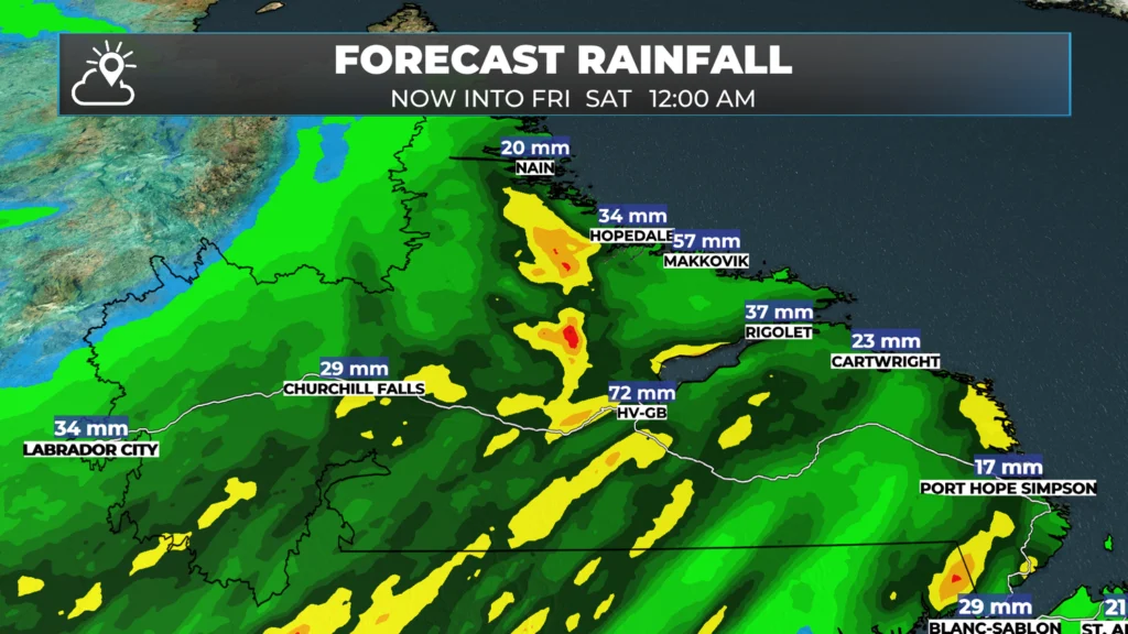
An intense area of low pressure will track through Labrador today. This will bring rainy and breezy conditions to much of the Big Land today and tonight. A Rainfall Warning is in effect for the Happy Valley-Goose Bay and Eagle River areas, predicting up to 60 mm of rain by late tonight, when the rain is expected to end.
The rainfall forecast from late last night thru midnight Friday night
Some high winds will be found along parts of the coast later today and this evening as well, with gusts nearing 70+ km/h from near Rigolet to north of Nain. Temperatures will vary across Labrador today, too, with southeastern areas reaching near 20 °C, while areas in the north and west will be closer to 10 °C. This is due to the circulation of the low-pressure centre.
Meanwhile, on the Island today it will be a bit of a different story. There are three main things about the weather you’ll notice:
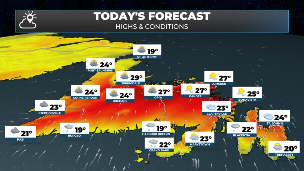
It’s going to be warm to almost hot again today… but not as hot as yesterday
It will be EXTREMELY muggy today!
The fog will be VERY dense along and near south-facing shores.
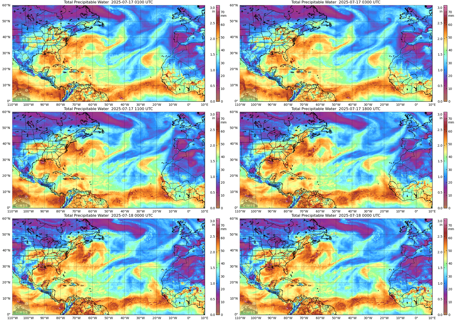
The reason for this is due to the Labrador Low. As that low passes west of the Island, it’s going to tap into some serious moisture. And that moisture is going to pass right over the Island. You can see that clearly in this loop. The bright colours represent moisture transport, and the more of that we see, the more muggy it’s going to feel.
Today will also not be as sunny as the last couple of days, but it will be breezy, with gusty winds from the south or southwest reaching speeds of about 60 km/h along parts of the coast. This may help fuel the flames of the Chance Harbour Fire somewhat, but because it’s so muggy, conditions for increased fire behavior aren’t as favorable as they were over the last two days. Temperatures today will peak in the teens and 20s, which is lower than the 30s of yesterday. However, with the high humidity, Humidex values will creep into the mid-30s in some areas.
Along with the RDF along the South Coast and south-facing shores (regardless of what the icons say), there will be some showers and possible thunderstorms across much of the Island today. They will arrive on the West Coast early this afternoon before heading east, and arriving in central late afternoon or early evening. The line of showers and thunderstorms appears to fizzle out before it reaches the Avalon Peninsula. Futurecast (below) does a good job of timing this out.
The showers and storms are associated with a cold front, and that front will push the muggy air offshore on Friday night. Behind it, for the weekend, we will see much more comfortable air in place, along with temperatures in the teens south to middle and upper 20s inland and farther north. While we are looking a great weekend, weather-wise, we still must remain vigilant about adhering to the fire ban. The fire hazard index will be very high again over the weekend.
Not so great on the muggy stuff, but love the idea of the weather brief. Thank you for bringing this to the weather scene in NL. Much needed. We have a very diverse climate, especially in CBS.
Thunder and lightning going on here in Bonne Bay right now but glad to see the rain! Can’t wait for the humidity to drop! Thanks for the great forecast, looking forwards to the clearer weekend!
⚠ Storm ModeGet warnings pushed to your phone the moment they’re issued.Get the app
By using this website, you agree to our use of cookies. We use cookies to provide you with a great experience and to help our website run effectively. Privacy Policy


Thanks eddie! Love the radar images on this one. 🙂
Thanks
Hoping to be able to fish in Triton area , hoping low wind , thoughts?
Eddie, loving your new app! Fantastic job on developing the app! Have recommended it to many family and friends! It will be a hit!
Great job Eddie. Thanks.
Congrats on developing this app. I follow you to obtain the weather info. I love your maps and models. Thanks Eddie.
Great job Eddie. I love your new app
Raining here in Mount Carmel now. Much needed. Great app
WTG.
Great post. Excellent graphics.
Thanks!
Thank you,looking forward to seeing the weekends forecast .
Not so great on the muggy stuff, but love the idea of the weather brief. Thank you for bringing this to the weather scene in NL. Much needed. We have a very diverse climate, especially in CBS.
Looking forward to tomorrow’s forecast! A wedding is happening!
Thank you Meteorologist Eddie Sheerr!
Tks Eddie. Always appreciate your detailed forecast each day 🤗
Love the warm temps but not so much the humidity
I’m loving your new app and the very detailed weather forecast. Great job Eddie
Thanks Eddie. Great update. Keep up the good work. 👍
Thank you Eddie.
Absolutely loving your new app! Very informative. I’ve deleted all others. Keep up the good work!!
Absolutely love that when i get up the outlook for the day is right there in my notifications. Great job on the app. Cheers
Thanks for the update Eddie
Thanks for the comments!! 🙂
Thank you for sharing Eddie. Hope you have a great weekend as well. 💖
Good morning Eddie. Happy wknd!
Awesome app Eddie! Miss your face
You are rocking this Eddie. Just saying 👊🏻
Awesome app. Eddie! Have a great weekend.
Great forecast there sheer
Great forecast Eddie
Awesome forecast for the island! Too bad I’m in Iqualuit sitting at 6 degrees….lol. At least it’s sunny today!
Thank you !! 😊
Thunder and lightning going on here in Bonne Bay right now but glad to see the rain! Can’t wait for the humidity to drop! Thanks for the great forecast, looking forwards to the clearer weekend!
Eddie
Your forecast is very informative. I enjoy reading it.Best of luck with your new venture