
Kingston Fire grew overnight; new evacuation ordered for Western Bay
Late last night, the Provincial Government ordered the mandatory evacuation of the town of Western Bay due to the Kingston Fire, and placed the town of Ochre Pit Cove on evacuation alert. This is in conjunction with the evacuation orders already issued for the Town of Small Point-Adam’s Cove-Blackhead-Borad Cove and Kingston. A separate fire burning near Holyrood and the southwest portion of Conception Bay South has also prompted evacuations.
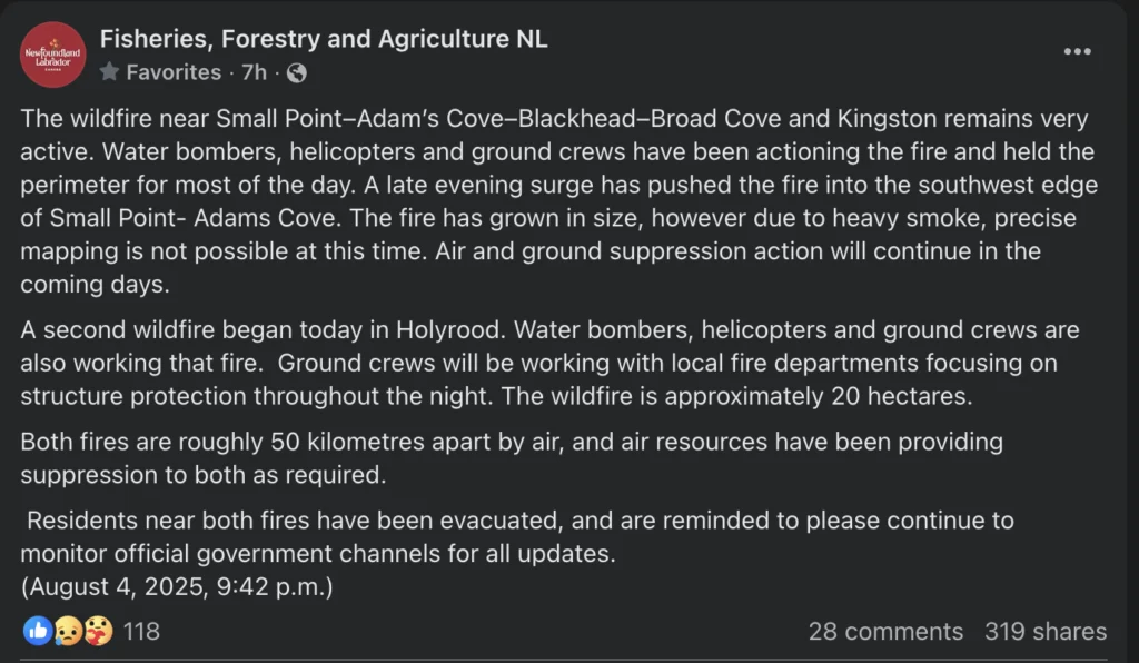
Tap the image to be taken the source of this screenshot.
This morning’s forecast is brought to you by Roebothan, McKay and Marshall.

Visit MakeTheCall.ca for more
NASA FIRMS imagery shows hot spots have grown toward the northeast on Monday and overnight, pushing the fire into Adam’s Cove and not far from Western Bay. This is due to southwesterly and south-southwesterly winds. The fire will move in the direction the wind is pushing it for the most part.

NASA FIRMS imagery showing the scope of the Kingston Fire as of early in the morning on August 5, 2025
NASA FIRMS stands for Fire Information for Resource Management System. It’s a tool that uses satellite data to detect heat and fire “hotspots” from space. These hotspots are shown as small colored squares on a map — usually red or orange — and they indicate areas where there may be a wildfire or significant heat. The service also shows the fire has grown significantly in size and is far bigger than the 256 hectares the Province states on the Fire Information Dashboard. This service estimates the fire to be around 1,400 hectares in size.
Holyrood Fire
Late last evening, the Town of Holyrood declared a STATE OF EMERGENCY due to the fire, for the area of Route 60 from Beaumont Place to the bridge of the entrance into Holyrood. including Duff’s Road and Green Acres Subdivision. The town goes on to say the following:
Pursuant to Section 196 of the Towns and Local Service Districts Act (2023), an evacuation order is hereby issued for this section of Holyrood.
All residents who have evacuated due to the wildfire are asked to please register with the Canadian Red Cross, in person, at the new Conception Bay South Arena, located at 13 Graham Mifflen Dr, Conception Bay South or by calling 709-729–0921.
NO RETURN to area until safe to do so has been declared by the Town of Holyrood.
Patrols and fire resources will be maintained throughout the night.
Please read the declaration of state of emergency and evacuation order attached.
The fire burning near Holyrood was estimated to be 20 hectares in size yesterday evening. There is no proof I currently have, but I suspect the fire is likely larger in size than that. By how much, I’m not sure.
Current Conception Bay South Evacuation Information
Evacuation Notice
An evacuation order is now in effect for the area from 1820 Conception Bay Highway to the western boundary of Conception Bay South. Anyone who has been evacuated, please register at the Conception Bay South Arena.
Preparedness Advisory
Residents from 1375 Conception Bay Highway to 1820 Conception Bay Highway, including all roads in between, are asked to prepare to evacuate should it become necessary. Residents in the advisory zone are not required to evacuate at this time but should be prepared in case the situation changes.
Additional information will be released as necessary.
Today’s expected weather conditions for fire locations
Kingston Fire
The thing that moves and spreads wildfire, above all else, is wind. The wind will push the fire in the direction it’s blowing. The wind direction yesterday was from the south-southwest, so the fire moved north-northeast. Today the wind will turn westerly, northerly, and eventually northeasterly. This should prevent the fire from advancing much farther north; however, it will initially push it toward the east. Current forecasts indicate that between 12 and 1 PM, the wind will shift toward the northeast in the area. That will start to push the fire back toward areas it has already burned. This will hopefully slow the fire growth and allow the action on the fire from the air and ground to continue in full force. Temperatures today are also expected to be lower (mid to upper teens), and the relative humidity is anticipated to be higher (above 50%). The combination of these elements should yield less extreme fire behavior today.
Holyrood Fire
The forecast for this area is a little different, but the winds are expected to also turn onshore, from the north northwest to north northeast this morning. Much like the Kingston Fire, the wind shift will cease pushing the fire toward CBS and will hopefully allow crews fighting the fire to do so more effectively. Temperatures here will be warmer (low 20s) and humidity levels lower (30-40%) than farther up the bay. So while not all factors are leading towards the potential of more fire growth today, the fire may still exhibit some less-than-ideal behavior.
Poor Air Quality
A Special Air Quality Statement is in effect for the Avalon Peninsula North and St. John’s and vicinity. Smoke from the wildfires over CBN and Holyrood is impacting air quality in these areas, and local smoke concentrations will vary with changing winds.
As smoke levels increase, health risks increase. Limit time outdoors. Consider reducing or rescheduling outdoor sports, activities and events. You may experience mild and common symptoms such as eye, nose, and throat irritation, headaches, or a mild cough. More serious but less common symptoms include wheezing, chest pains, or severe cough. If you think you are having a medical emergency, seek immediate medical assistance.
When indoors, keep windows and doors closed as much as possible. When there is an extreme heat event occurring with poor air quality, prioritize keeping cool. Protect your indoor air from wildfire smoke. Actions can include using a clean, good-quality air filter in your ventilation system and/or a certified portable air cleaner that can filter fine particles. If you must spend time outdoors, a well-constructed, well-fitting, and properly worn respirator-type mask (such as a NIOSH-certified N95 or equivalent respirator) can reduce your exposure to the fine particles in the smoke.
Even though exposure may be reduced, there can still be risks to health. Check in on others who are in your care or live nearby who may be more likely to be impacted by outdoor air pollution.
Provincial Forecast
Across the Province today, we are going to see lots of sunshine and very little, if any, rainfall. Temperatures will climb into the teens and 20s for many areas as a ridge of high pressure builds in. The weather for the remainder of the week will not be much different… in fact, as I mentioned yesterday, it will only get warmer.
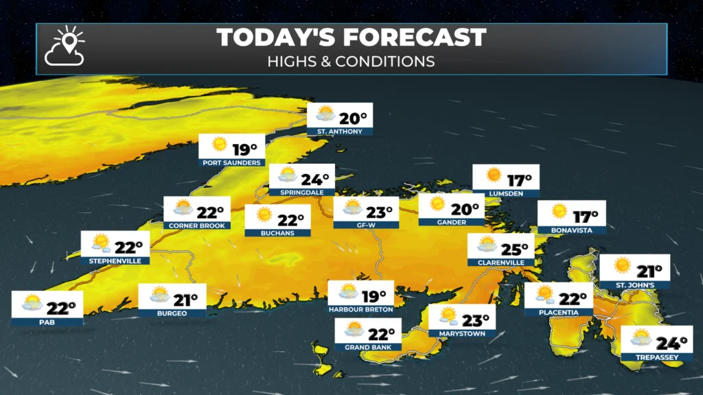
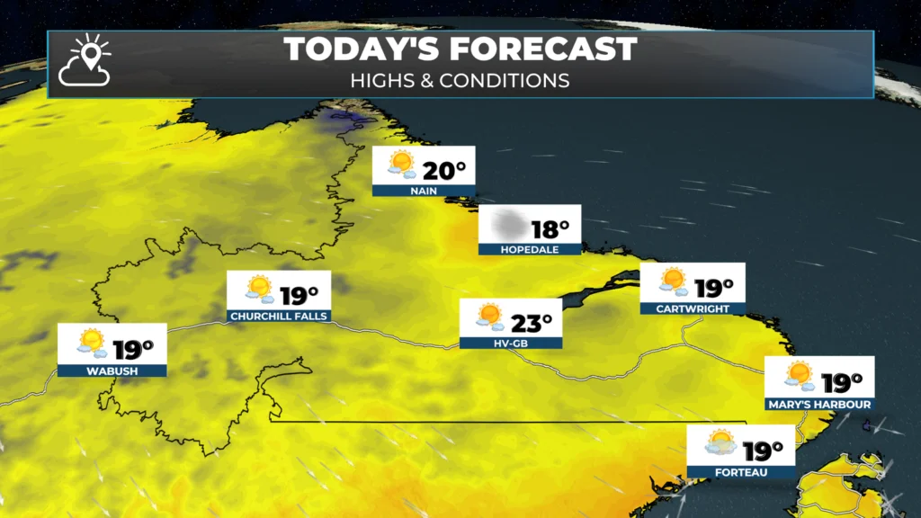
The fire danger is only going to increase, and I suspect the map below will show ‘Extreme’ for most areas later this week. Please follow all local regulations and guidelines. When multiple fires are ongoing, resources are stretched to the limit. A fire ban may also be in the works, if it isn’t already.
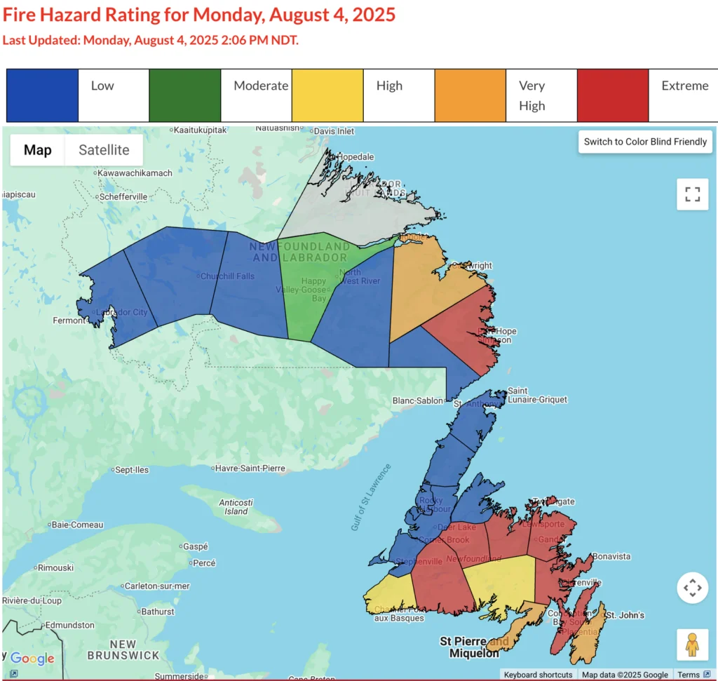
I’ll have more updates throughout the day. Check back here, follow me on socials, and get the app to be as up to date as I can get you about this situation and the weather across the Province.
Stay safe.
Eddie
Thanks for the detailed info. Greatly appreciated!
Good morning Eddie thanks for the info have a great day 👍👍
Tks for detailed update Eddie
Great update , Eddie.
Tks.
Thank you for the update
Wow! Very informative. Thanks!
Thank you for the informative update.
Thank-you, Eddie! So great to know your thoughtful, well-explained updates are available on this app.
Thank you for keeping us informed in such detail in all areas.
Thanks for the updates! Great work!
Thanks for the update Eddie
Hi Eddie, your new app is such a great resource. Not only for weather but for such things as fire information, especially this year as things are really bad. I suspect hurricane information will be a great benefit as well as our winter weather that we know is coming. I love reading your blog first thing in the morning and the alerts are always great. You are doing a remarkable service for everyone.
Thanks for the update, Eddie. Hopefully everyone stays safe especially the fire crews.
Absolutely love your new APP. It’s the only one I follow now. I used to check at least three before .
Great weather app best I’ve used keep up the good work Eddie
Great weather app, Eddie. Plus all the latest updates on the fires. Thanks !
Is the Holyrood fire under control.
Evacuation now for Perry’s Cove.