
Friday morning update — August 15, 2025
Good Friday morning.
Here is the latest on the fires from Fisheries, Forestry, and Agriculture, Newfoundland and Labrador
• THE KINGSTONE FIRE (SIZE: 8,019 HECTARES)
Water bombers and heavy helicopter worked the southern edge of the fire Thursday, with low ceilings delaying the start to the day and very heavy smoke impeding work at the northern edge. An evacuation alert has been issued for the unincorporated area of Job’s Cove. Residents are asked to be ready to evacuate on short notice if required.
Water bombers and helicopters will work on the northern edge this morning if conditions permit. The forecast indicates improving conditions for fire suppression with cooler weather and a chance of showers.
Ground crews will be on site this morning. We will continue working with RCMP and towns on structure loss assessment when safe to do so.
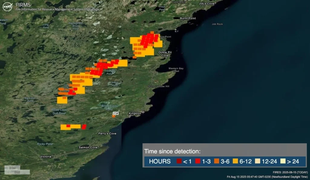
NASA FIRMS IMAGERY/ 5:51 AM / FIRE INFORMATION MANAGEMENT INFORMATION SYSTEM US/CANADA
THOUGHTS FROM ME THIS MORNING
The image above suggests that over the last 24 hours, the fire has been most active on the north and west flanks. Notice the red and orange squares? Those are all hot spots that have been detected within the last 12hours at most. This is likely why the evacuation ALERT was issued for Job’s Cove. This is also why FF&A plans to work on the northern edge this morning, if weather conditions allow.
Remember that flying is a dangerous business on a good day. Flying heavy aircraft at low altitudes loaded with water is more challenging and dangerous than many of us, including myself, an avid aviation enthusiast, fully appreciate. The decision to fly or not fly is not arbitrary and is based on a multitude of factors, with visibility being a significant part of it, as flying low requires having no doubts that visual references will not be obscured. I want these fires put out as much as anyone. However, the action from the air can only happen if it’s safe to fly.
The weather this morning should hopefully cooperate, as it appears we are starting the day with clear skies. However, the smoke being blown to the northeast may present some challenges.
• PADDY’S POND FIRE (SIZE: 306 HECTARES)
Water bombers and a bird dog aircraft were focused on the northern edge of the fire. Bucketing will continue Friday. Construction on a fire guard is complete and more work will continue in the morning with help from the Canadian Armed Forces.
• MARTIN LAKE FIRE (SIZE: 2,160 HECTARES)
Minimal growth was reported on the Martin Lake fire Thursday, and fire did not cross Route 360 (Bay d’Espoir Highway). Aerial suppression continued throughout the day, including structure protection. Route 360 remains closed until further notice
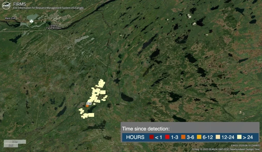
NASA FIRMS IMAGERY/ 5:51 AM / FIRE INFORMATION MANAGEMENT INFORMATION SYSTEM US/CANADA
The morning’s forecast is brought to you by Roebothan, McKay and Marshall.

Visit MakeTheCall.ca for more!
Today’s Forecast
A cold front will sweep across the Island today. As the cold front moves through, there will be an area of rain, showers, and thunderstorms that accompany it. The area of rain this morning is located just inland from the West Coast and east of the GNP.
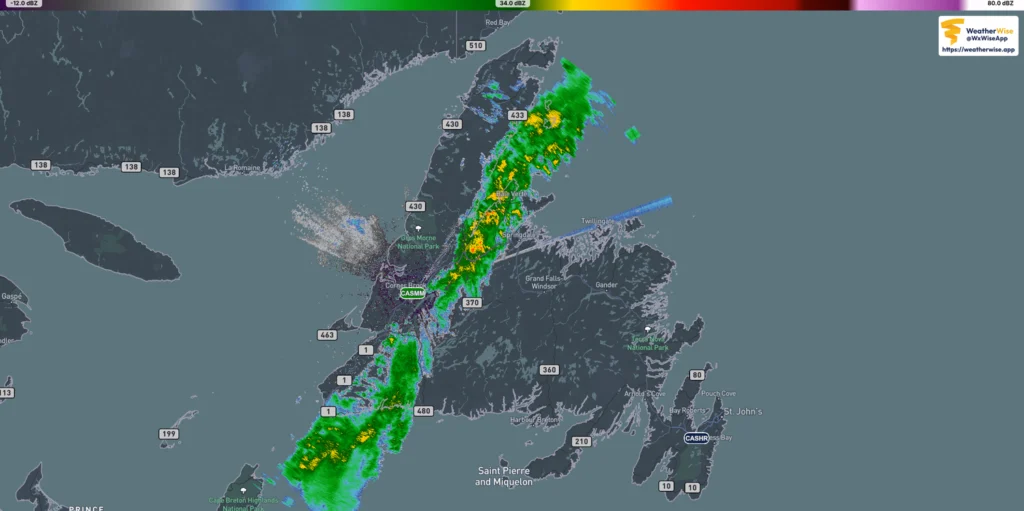
We will watch this line move eastward today. Computer guidance suggests the rain will get less widespread through the day and the showers and thunderstorms will become more of what is seen over eastern and northeast Newfoundland this afternoon and this evening. Futurecast shows this well; however, keep in mind that shower placement is hard to forecast.
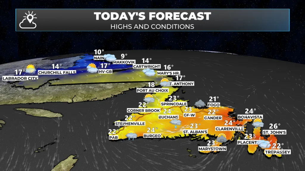
Temperatures today will not be as hot as yesterday and the day before; however, southerly winds will continue over eastern Newfoundland until the evening, when the wind changes to northerly. The shift in the wind will lead to a drop in temperatures and should mitigate the extreme behavior of the Kingston Fire and Martin Lake Fire for at least the next couple of days.
Temperatures will drop sharply today and tonight behind the front, and we are only looking at highs in the lower to mid-teens for much of the region tomorrow. Similar to what Labrador dis going to see today. Sadly, there isn’t much rain in the forecast for the next 5 days or so, even behind this front. I’ll have that forecast for you later today.
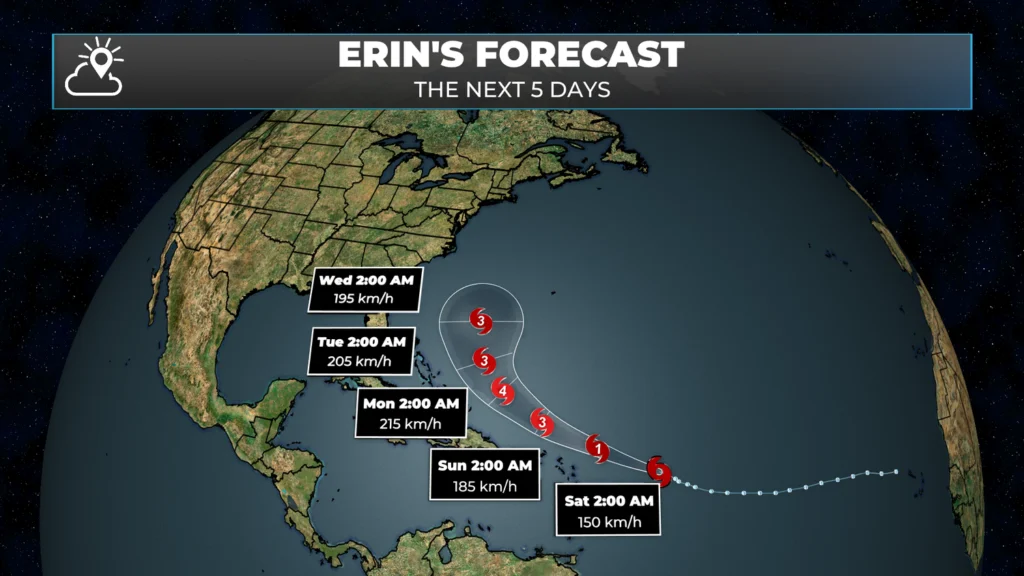
Beyond this, our attention turns to Tropical Storm Erin. The storm is still thousands of kilometers to our south, but may impact the weather near/in our region toward the middle or end of next week. Right now, that’s something to watch. If that changes, you know I’ll be here to let you know!
Stay safe.
Be sure to get my app if you haven’t yet!
Thanks,Eddie! Near Horsechops pond this early morning in Travel trailer, but being very fire aware.
My first look each morning is Sheer App
Thanks for the update, loving this app
Thank you Eddie for your amazing updates. I check every morning. I cant wait for the cooler temps. My curly hair and asthma is not thriving in the heat and humidity lol
Thanks for the update Eddie
Good morning Eddie, thanks for update.. love your app!
Thank you for everything you’re doing with the updates and imagery. Do you have the NASA image for Paddy’s Pond for this morning? Thanks again!
Good morning Eddie, hopefully good news with these cooler temps!
Thanks Eddie
Thank you ever so much for all your doing.
I’m loving your app
Happy Friday! 😁
Love your app. Miss you on the news.
Good Morning! A very detailed weather report Eddie. Oh how I wish this situation was in the past, my heart goes out to those who’ve lost everything …. and it’s not over yet
This app is fantastic. I’m in PEI and last night I was receiving alerts about lightning being detected close to my location! Big dry thunder and lightning storm moved in.
Thank you Eddie. You are doing an amazing job at keeping us up to date on everything that’s going on here at the moment. You are truly appreciated. An Yes! I have your app Lovin it
I start my day with your app and weather blog. Thanks Eddie!
Hope those lovely clouds drop some rain on us today. Sounds like quite a bit of activity in the air this morning as well. Feeling more positive today and praying for all evacuees, firefighters and decision makers. Thanks for the update this morning, it’s becoming part of my morning routine.
Thanks Eddy. Appreciate the indepth info.
First thing I go for in the morning is your weather app. Thanks for all the updates Eddie, you are very much appreciated!
Thank you, as always for the great job Eddie!
Thanks Eddie. My go to app
Never thought I’d be rooting for hurricane remnants to hit the island yet here we are….thanks for your work
Love your APP, Eddie. It is the first thing I open each morning, especially with the updates about the fires. WTG
Excellent update Eddie.
Tks.
Thanks for your updates and the app is the best!You rock Wddie Scheer!
Looking forward to the rain. Very strange to be saying it. Question Eddie, will it be enough for the ground to hold the roots of many of my big trees, if we get a lot of wind
TYVM for my morning update. I live in GFW. Several of my family and friends are impacted by the Martin Lake fires.
Thanks for the update Eddie
Thanks for the updates Eddie. Love your app…Always a fan!
Great app eddie
Thanks Eddie; I always count on you for an accurate forecast. Keep up the good work!!!