
Thursday morning weather brief | August 7, 2025
Good Thursday morning!
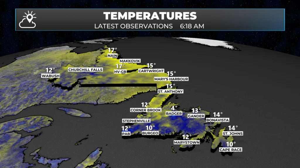
We are waking up to clear skies and comfortable temperatures across the majority of the Province. Readings are generally into the teens, with a few exceptions.
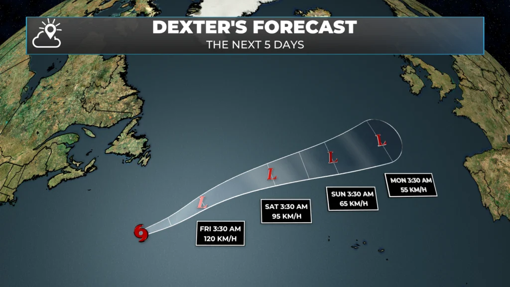
The weather across the region today will be dominated by high pressure moving in. This will result in another sunny day across Atlantic Canada. The wind will be slightly higher today and will generally blow from a westerly direction. The exception may be on the Avalon, where wind direction varies slightly from place to place. Guidance suggests the wind will be from the west this morning, turning north this afternoon, and then going south this evening. This is partly due to the high building and partly due to Tropical Storm Dexter passing well to our southeast today.
This morning’s update is brought to you by Roebothan, McKay and Marshall

Visit MakeTheCall.ca for more
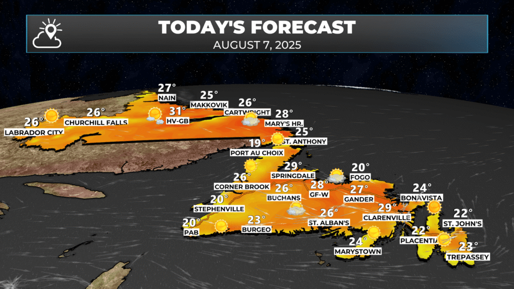
Temperatures today will climb into the middle and upper 20s for much of the region. Parts of Labrador are under a HEAT WARNING for the next several days due to temperatures expected to be near 30 and lows above 16. I suspect the Heat Warning may be expanded to more areas as the entire Province is going experience some of the most widespread heat I can remember forecasting in my 12+ years living here. Temperatures are forecast to run as warm as 10º above normal for the next several days.
Additionally, very little rain is forecasted for the same time frame. The image below shows the predicted precipitation over the next 10 days. While this means we are in for some great summer weather, it means we are not going to see any help from Mother Nature with respect to the ongoing fires. In fact, the fire risk is expected to continue increasing. Please remember there is a Provincial (NL) Fire Ban in place until at least September 7, 2025.
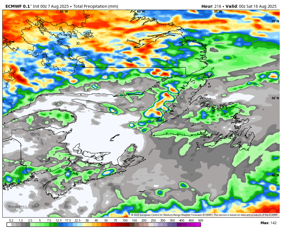
Forecast for rainfall over the Province through Friday, August 15, 2025. Note the lack on the Island?
AIR QUALITY ALERTS
Ash from ongoing wildfires has been reported falling in Victoria and the surrounding area. Wildfires significantly impact air quality, as smoke contains fine particles and pollutants that can pose health risks, particularly to vulnerable groups such as children, seniors, and individuals with respiratory conditions.
High pressure building across the region will lead to sinking air and may result in air quality becoming worse for some areas near the fires over the coming days.
For the latest air quality conditions and health guidance, visit the Air Quality Health Index (AQHI) and AQmap.
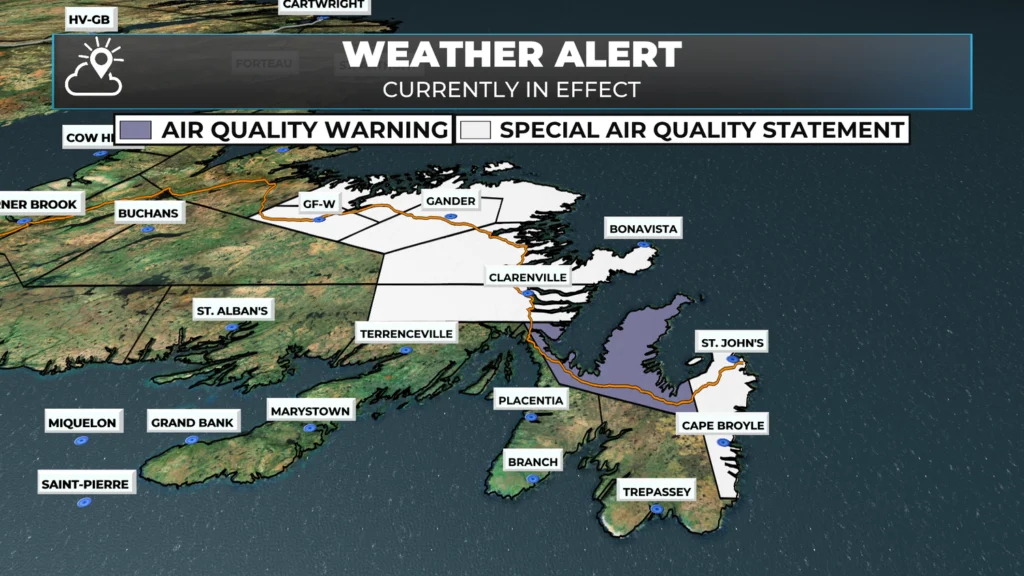
Special Air Quality Statements remain in effect for:
St. John’s and vicinity
Bonavista North
Gander and vicinity
Terra Nova
Clarenville and vicinity
Bonavista Peninsula
Air Quality Warnings have been issued for:
Avalon Peninsula North
Grand Falls-Windsor and vicinity
Bay of Exploits
AQHI (Air Quality Health Index) Forecasts:
St. John’s: Low risk today with maximum values of 2 (Low Risk), except 7 (High Risk) in areas impacted by smoke, through Thursday night.
Grand Falls-Windsor: Forecasted as Moderate Risk overall, with peak values of 10 (High Risk) in smoke on Wednesday, and 2 (Low Risk), except 7 (High Risk) in smoke, through Thursday night.
Residents are advised to limit outdoor activity during periods of heavy smoke and to follow public health recommendations, especially if experiencing symptoms such as coughing, throat irritation, or difficulty breathing.
WILDFIRE UPDATE
Late last evening, Fisheries, Forestry, and Agriculture, Newfoundland and Labrador, released a statement about the status of the fires burning on the Island.
The Kingston wildfire remains very hot and smoky. Today ground crews concentrated their efforts on the southern edge while three water bombers, three helicopters, and a bird dog aircraft provided aerial suppression. Monitoring will continue overnight. The Incident Management Team anticipates taking a similar approach to attack the fire tomorrow.
Crews are reporting a good day on the wildfire in Holyrood. Air and ground crews have made progress suppressing hot spots within the area, however, there is still fire activity on the western edge. Tomorrow will see a continuation of this approach, with one helicopter and ground crews continuing to work hot spots. Additional air support will be provided if needed.
The Martin Lake wildfire has expanded along the southern edge but remains contained along the northeast edge. The approximate size of the fire is 220 hectares. Three 802 aircrafts provided by New Brunswick worked the southwest edge. Sprinklers have been installed on the cabins closest to the fire along Martin Lake for added structure protection. Tomorrow, one water bomber, three 802 aircrafts and three helicopters will continue with arial suppression with ground support when possible.
CURRENT EVACUATION ORDERS AND POTENTIAL EVACUATION NOTICES
AS OF AUGUST 7th AT 6 AM
Small Point–Adam’s Cove–Blackhead–Broad Cove, Kingston, Western Bay & Perry’s Cove are under mandatory evacuation. Residents must register with the Red Cross either in person at Persalvic School in Victoria or by calling the registration line.
Holyrood: Sections from the town boundary to 377 Conception Bay Highway and westward to the boundary with CBS remain under an evacuation order. Registration is taking place at Villanova Junior High.
Conception Bay South: The area west of 1820 Conception Bay Highway is under evacuation.
Cabin areas near Martin Lake, Great Rattling Brook, and Rushy Pond (off Route 360) have been ordered evacuated due to nearby wildfire activity. Travelers are urged to avoid the area, as Route 360 may be closed without notice.
Evacuation Alerts (be ready to leave):
Salmon Cove and Ochre Pit Cove remain under evacuation alert. Residents should be ready to leave at a moment’s notice.
A section of CBS between 1375 and 1820 Conception Bay Highway is also under evacuation alert.
A province-wide fire ban remains in effect until at least September 7, and backcountry travel in Gros Morne National Park is prohibited due to redirected emergency resources. In addition, air quality warnings remain in place for parts of the Avalon Peninsula due to smoke.
For the most up-to-date information and detailed instructions, visit gov.nl.ca/alerts and follow official government sources.
As more details become available today, I will pass them along. Please heed all alerts and do our part to prevent the ignition of new fires. Be sure to get the Sheerr Weather App for my latest updates!
Thanks so much.
Thanks Eddie…love your app it’s the first thing I check everyday and look forward to your updates
Good morning Eddie
Thank you for the update!….Have great day!…..Love your app
Love your app. Great updates…
My “go to” app! Appreciate and now depend that you always the most current updates
Love you app; very detailed information again. Thanks.
Good morning!! Thank you for the update!! You are doing a fantastic job!! Keep up the great work!!
So appreciative of your morning updates! Clear, concise and tailored to what we need and want to see. Living near the CBN fire being able to read your thoughts each morning has been a big help in reframing to focus on facts rather than let fear take over.
Tks Eddie. You r always soooo explanatory with the weather update 🤗Love the app and your detail.
Thank you, Eddie. Your detailed posts help me maintain perspective and make decisions while away from home in Upper Gullies.
Keep up the good work reporting the weather enjoying your app
I find myself checking in with your site first thing in the morning
You are right up there with my morning wordle.
Thanks GREAT WORK
Good morning, thanks for the update on everything today.
Take care.
Thanks so much Eddie! Your updates are great and we depend on them.
Good Morning Eddie. Another beautiful day. It’s a shame we finally get sunny, hot days, then we have to cope with disastrous wild fires. There’s no happy medium. Thoughts going out to the less fortunate families having to leave their homes, not knowing what the end result will be.
Thanks for the update Eddie. Much appreciated!
Thank you! Good info
Great updates