
Monday morning weather brief — August 11, 2025
This morning’s update is brought to you by Roebothan, McKay and Marshall.

Visit www.makethecall.ca for more!
Good Monday morning.
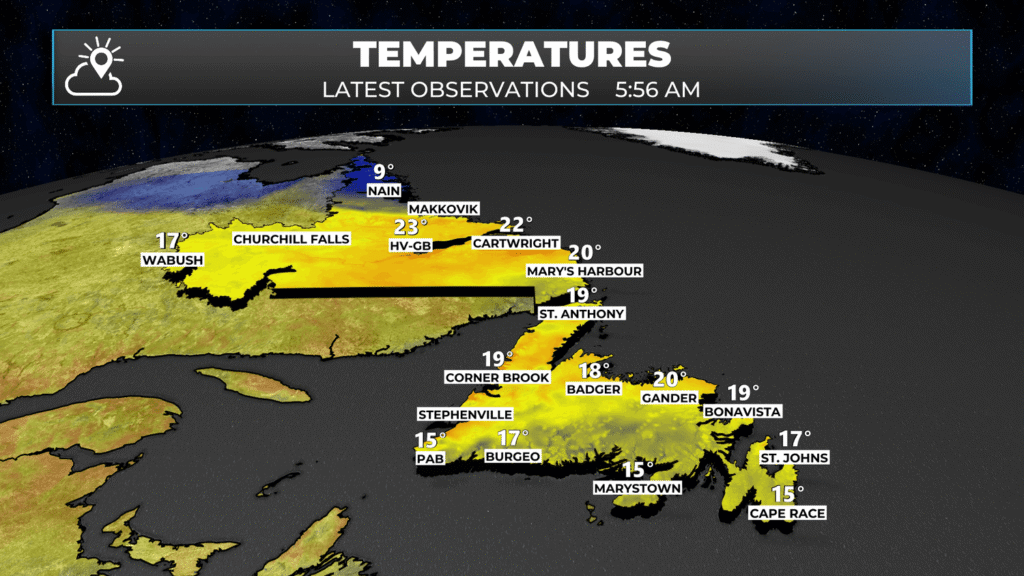
We are starting off the day with partly cloudy skies and temperatures in the upper teens and low 20s. The exception is Nain, where the current temperature is 9º.
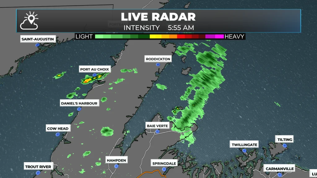
There are a few showers around the Island to begin the day, and radar shows they are located over the Northern Peninsula, Baie Verte Peninsula, and potentially around Notre Dame Bay.
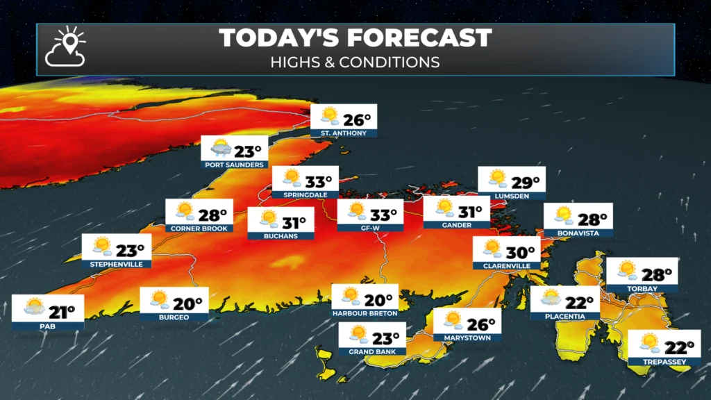
The weather today will be much like the last few, with some slight changes. It will be sunny, warm to hot, and dry on the Island, with highs climbing into the mid-to-upper 20s for most areas. The exception will be near south-facing shores, where onshore winds will keep readings closer to 20º.
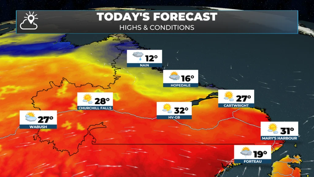
In Labrador, temperatures will also climb into the 20s to near 30º for most areas today. There will be some scattered showers and thunderstorms this afternoon, particularly in the west.
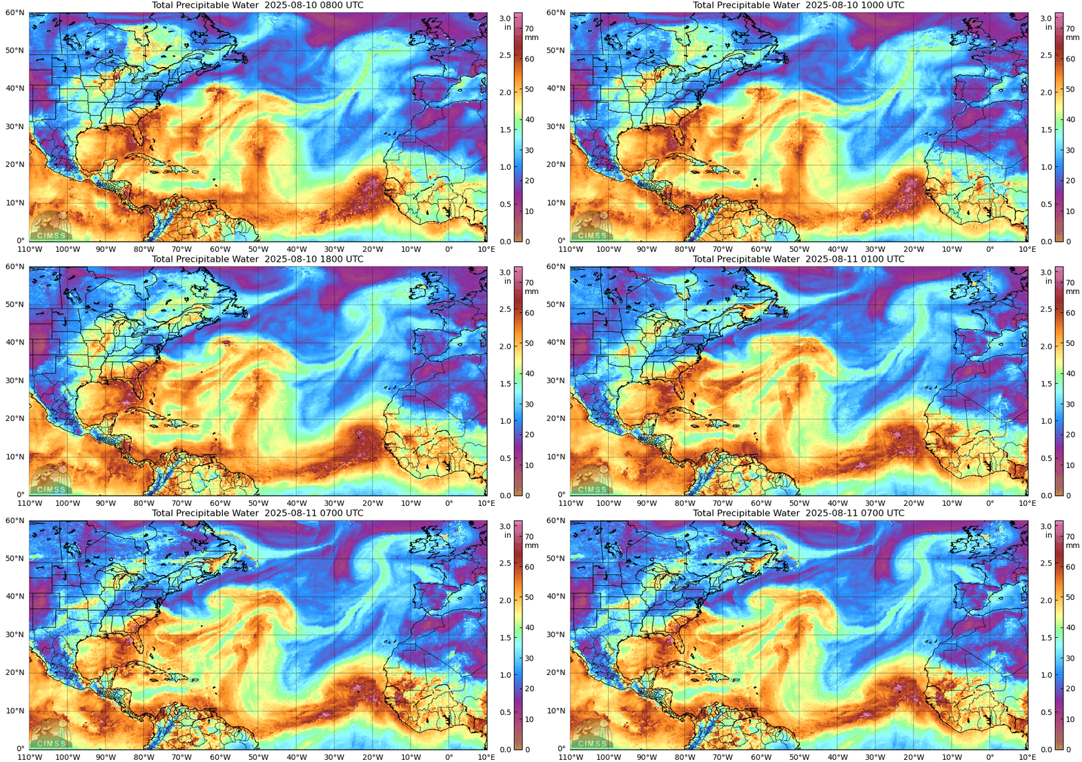
One of the things you’ll notice today is that the air will be a bit more humid. We are seeing increasing amounts of moisture in the air, known as precipitable water, which will increase humidex values above the air temperature value by quite a bit in some locations. The animated GIF below shows this well. The bright colours indicate air with more moisture, or humidity, in it.
The Next Chance of Rain…
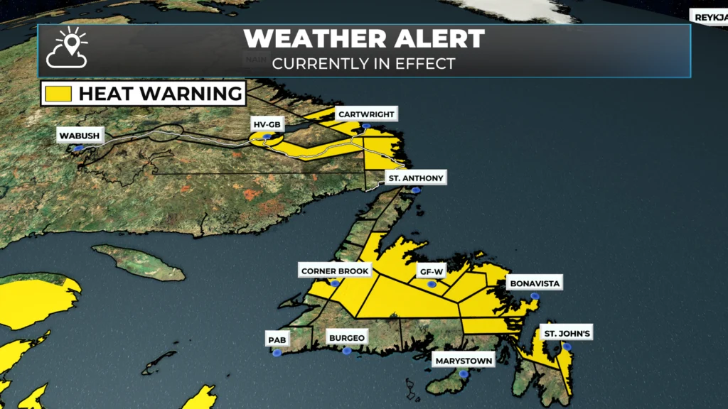
Computer guidance indicates the next chance of meaningful rainfall over parts of eastern and central Newfoundland could be Thursday as what’s left of a tropical system moves onto the Island. I’ll have more updates on this later today when I have a chance to dig into the data a bit more. Beyond that, the weather remains largely unchanged, minus the increase in humidity, until then. Heat Warnings remain in effect until Wednesday or Thursday, as it looks now.
WILDFIRE UPDATE
Fisheries, Forestry, and Agriculture, Newfoundland and Labrador, provided an update on the wildfire status at 9:30 PM last evening. I’ve copied and pasted it below this section for your convenience. Here are some key highlights:
Kingston Fire: Crews expanded the southern fuel break near Salmon Cove and held the northern edge with water bombers, slowing growth to over 5,000 ha. Additional structures impacted in Adams Cove/Kingston and Western Bay, but counts remain unclear.
Holyrood Fire: Still at 22 hectares, Being Held with full containment via hose lines. Crews and helicopters continue to monitor and address hotspots.
Martin Lake Fire: Minimal growth as crews completed nearly 1 km of fuel break. Air support held the northern edge; Route 360 remains open with no cabins impacted.
HV-GB Fire: Lightning-caused blaze south of Happy Valley-Goose Bay held to a few hundred meters by helicopters and ground crews.
Late Evening Update from Fisheries, Forestry and Agriculture, Newfoundland and Labrador
Wildfire ground crews were able to remain on the Kingston fire throughout the day today and made progress on expanding the fuel break on the southern edge of the fire near Salmon Cove.
Work continued to remove fuel and expand the size of the fuel break along the sections constructed by heavy equipment. The Incident Command Team hopes to continue this work in the coming days to create large fuel break along the entire southern edge of the fire.
Water bombers were focused along the northern edge of the fire and were able to mostly contain fire spread on the north leading into the early evening.
The effectiveness of this suppression means the fire is not expected to reach as far north as was previously projected.
The helicopters including two from the Canadian Coast Guard were used to assist with fuel break construction, bucketing spot fires in and around homes, and to transport crews and fire-fighting foam to the fire.
Ground crews on the southern edge today were joined by a 20-person crew from Ontario, bringing the ground crew numbers on the fire up to 50, as well as local fire departments working on structure protection.
The fire has grown to over 5,000 ha, but growth today was substantially slower than yesterday. Additional structures have been impacted in Adams Cove/Kingston, and Western Bay based on fire growth since yesterday but heavy smoke and difficult conditions made estimating the number of structures and exact properties difficult.
The Holyrood fire remains at 22 hectares with no growth reported. The fire is classified as Being Held, with minimal fire behavior observed and the fire fully contained with hose lines. Crews continue to work on the fire.
Helicopter bucketing and monitoring are ongoing. Crews are working with support from local fire departments with water supplies to handle any hot spots. Search and Rescue are scanning for hotspots this evening.
The Martin Lake fire was active today, challenging fire crews attempting to keep the fire pinned to the western edge of the lake. Construction of the fuel break between Martin Lake and Great Rattling Brook continued with nearly 1 km of the fuel break completed. Water bombers, air tractors and bucketing helicopters worked to keep continuous suppression on the northern edge of the fire, holding it back and allowing crews to work on the fuel break. Fire growth was minimal and crews are now better positioned to continue holding the fire tomorrow. There remains no impact on Route 360. Officials continue to closely monitor the status of the highway. No cabins have been impacted.
A lightning-caused fire about 20 km due south of Happy Valley-Goose Bay flared up today. Two bucketing helicopters and ground crews from Happy Valley-Goose Bay were able to respond quickly and have kept the fire limited to several hundred meters in size. Helicopters and ground crews will return to work on the fire in the morning.”
— Fisheries, Forestry and Agriculture Newfoundland and Labrador | August 10, 9:30 PM
The quote above made the point that the fire behavior for the Kingston Fire wasn’t as extreme yesterday. This is likely due to the increasing amount of humidity in the air. The amount of moisture in the air over the next few days will hold steady or increase. And while that may make it a little more uncomfortable to be outside, it could be a help in the fight against the Kingston Fire.
Wildfires need three things to burn hot (wildfires burn at different temperatures) and fast. They need dry air, wind, and hot/warm temperatures. If you play with that formula, even a little bit, the fires often don’t behave as extreme. I’m hopeful that’s the case today.
The wind direction today will be from the southwest, meaning the smoke and fire will be pushed toward the northeast. Again, as stated above, a significant amount of work has been done on the north end of the fire to prevent it from spreading in that direction. Between that and the increased humidity, I’m hopeful today is like yesterday.
You can view the wind direction and weather forecast for today via the app or in the Map Room.
Updates to follow.
Thank you Eddie 🙂
Thanks for the update Eddie have a great day
Thanks Eddie for the updates
Thanks Eddy for the update.
Thanks and look forward to your greattvupdates
Thanks Eddie
Thanks for all the updates
Thank you for keeping me updated .
Tina , Salmon Cove
W0W this is awesome it’s all here for us to read thank you Eddie and God bless you ♥