Wednesday Morning’s Weather Brief — August 27, 2025
By Eddie Sheerr·
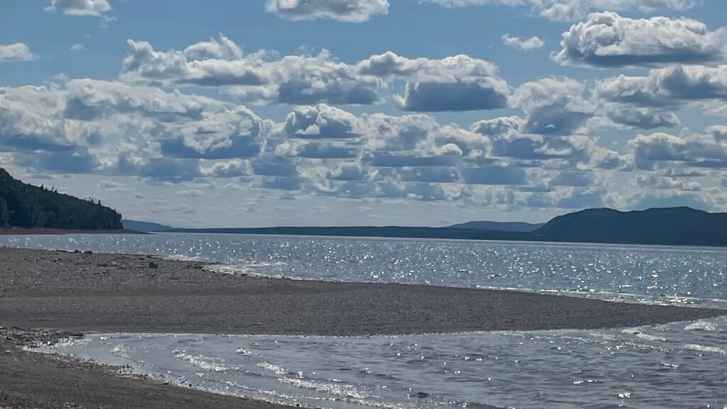
A photo of Beothuk Lake taken by Roxanne Hancock in July of 2025.
Good Wednesday morning!
Newfoundland and Labrador Premier John Hogan will brief the Province on the wildfires today at 9:30 AM. The Government of Newfoundland and Labrador’s YouTube channel will stream this live. I’ll also have the stream on my website and will send it to Facebook and X as well.
The Paddy’s Pond Fire has been declared OUT by the Province. No press release was issued, but the information was reported in a CBC article posted yesterday.
35 mm of rain fell on the Kingson Fire yesterday (August 26, 2025).
The fire is still listed as ‘Out of Control’ and is just over 10,000 hectares in size.
Most of the activity continues to be on the fire’s western boundary
Sponsored
This morning’s update is brought to you by Roebothan, McKay and Marshall.
Visit MakeTheCall.ca to find out what the law firm can do you for you!
Tuesday was a rainy day across much of the Province, and as Luke Bryan says in one of his songs, rain is a good thing! Many areas experienced drought conditions throughout the summer, and a heavy rain event was needed. Over 60 mm was recorded in Pool’s Cove, with lesser amounts found elsewhere. That being said, the ~30 mm of the Avalon received is nothing to sneeze at!
Beneficial rains over the past 24 hours across southern and eastern Newfoundland. Lesser amounts into Central, but every bit helps. #nlwxpic.twitter.com/ljsxqFYNi2
The rain we saw yesterday in St. John’s was a rarity this summer. In fact, the amount measured at St. John’s International Airport yesterday made it the wettest day since the end of April, according to the X account, YYT_Weather.
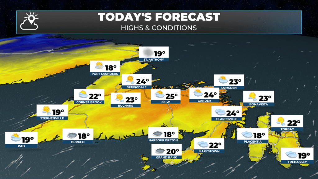
Today will be much drier than yesterday for the Island portion of the Province. I expect a mix of sun and cloud for most areas for most of the day. Clouds will increase from south to north this afternoon, and that will become more noticeable after 4 or 5 PM. Temperatures will peak in the lower to middle 20s for parts of central and eastern Newfoundland, with teens to near 20 being found west and on the GNP. Areas along and near south-facing shores will have highs in the mid-teens, with areas of fog.
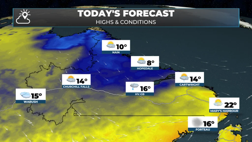
Showers will persist along and near the coast of Labrador from near Port Hope Simpson to the Torngats through much of the day. The showers become less widespread during the second half of the day. The showers will be more scattered from Goose Bay back to Labrador City and Wabush. High temperatures will be 10 to 15 degrees.
To see the forecast for YOUR area of the Province, be sure to check out the forecast pages on the website.
Tonight’s Forecast Highlights
A weak area of low pressure will pass east of the Avalon Peninsula tonight, and this will bring a few hours of light rain or showers to the Avalon and Burin Peninsulas overnight, especially in the southeast. Rainfall amounts do not look to be overly significant, but downpours may be locally heavy.
Lows dip into the teens over much of the Island and single digits and teens in Labrador.
Thunderstorms Thursday?
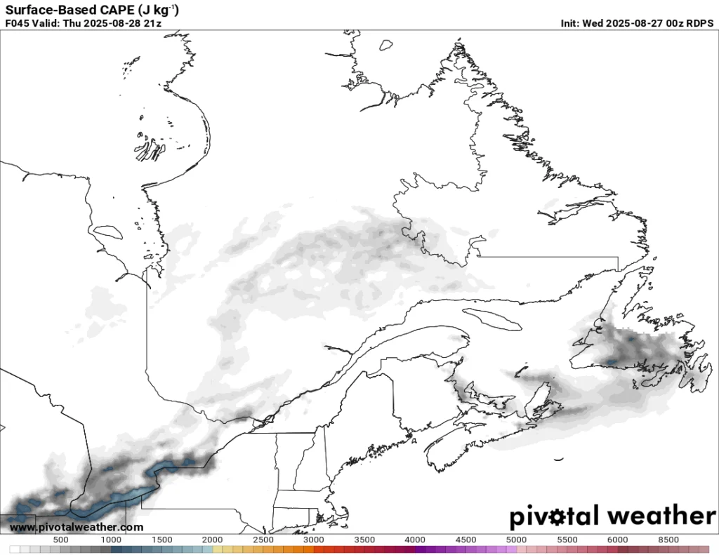
A cold front will move through on Thursday, and it looks like it will kick off some showers and thunderstorms over central and eastern Newfoundland in the afternoon. The best chance of storms right now appears to be for the interior, central, and eastern areas of the Island, including Avalon.
Thursday’s risk of thunderstorms as denoted by CAPE. Where you see shading on the map, the risk of thunderstorm exists. The brighter the colour, the higher the risk.
The best chance of storms on the Avalon will be in the north. Highs will be in the upper teens to lower 20s before the storms and showers, and in the teens after, as colder air moves in from the north. The Great Northern Peninsula and much of Labrador will see highs in the lower to middle teens on Thursday.
I’ll have a more detailed look at your long weekend forecast in my next update this afternoon. Have a great Wednesday and stay safe!
⚠ Storm ModeGet warnings pushed to your phone the moment they’re issued.Get the app
By using this website, you agree to our use of cookies. We use cookies to provide you with a great experience and to help our website run effectively. Privacy Policy


Thanks for the update
Thanks for update Eddie
Thanks for the update!
Great update Eddie. Love your ap.