
Both Record Warmth And Fluries Are In Tonight’s Forecast!
Unseasonably Warm Air Returns Briefly Before a Big Cool Down
We’re seeing near-record warmth across Labrador West this afternoon, with temperatures climbing into the upper teens and low 20s. Similar warmth is being felt across much of the Island. But this stretch will be short-lived as a cold front brings showers, cooler air, and even flurries for parts of Labrador later this week
Tonight & Thursday
Rain is spreading across Labrador tonight as a low pressure system tracks through the north. Behind it, cooler air quickly takes hold in western Labrador, setting up a sharp drop in temperatures by Thursday.
On the Island, however, a surge of warm air will arrive tomorrow. St. John’s could reach 22°C, which would mark the 80th day this year with a high of 20°C or warmer — breaking a record that dates back to 1942 at St. John’s International Airport.

This forecast is sponsored by Heat Pump Solutions. Heat Pump Solutions serves the Avalon and Burin Peninsula. Visit HeatPumpSolutions.ca to learn more about the products and services offered.
Friday & the Weekend
The warmth won’t last long. By Friday, Labrador will be much cooler, with highs of just 6°C in Labrador West and 7°C in Churchill Falls. St. Anthony also shows a cooler trend, with highs near 11°C. The rest of the Island will still be relatively mild Friday with highs in the upper teens and low 20s, but by the weekend, highs across Newfoundland will only reach the mid-teens — about 10 degrees cooler than Thursday.
In western Labrador, the first accumulating snow of the season may arrive late Friday night into Saturday, especially in higher terrain. Even a light coating would count as the season’s first measurable snowfall.
Tropics Update
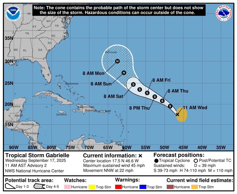
Meanwhile, in the Atlantic, Tropical Storm Gabrielle has formed with winds near 95 km/h. It is forecast to strengthen into a hurricane early next week. Current model guidance keeps the system recurving well southeast of Newfoundland and Labrador, posing no immediate threat to Atlantic Canada. Still, it will be monitored closely in the coming days.
Excellent work Eddie!
Only at the letter G in Hurricane names..what happened to all the Hurricanes due to Global Warming???
There is NO Climate Change,MOTHER NATURE controls our weather and the polar caps are from the last ice age, more warmth to come not by man but by HER !!
Thanks Eddie for the update