
Wednesday Morning’s Weather Briefing — September 23, 2026
Good Wednesday Morning! Here are today’s highlights
A chilly start this morning turns into a beautiful day across NL.
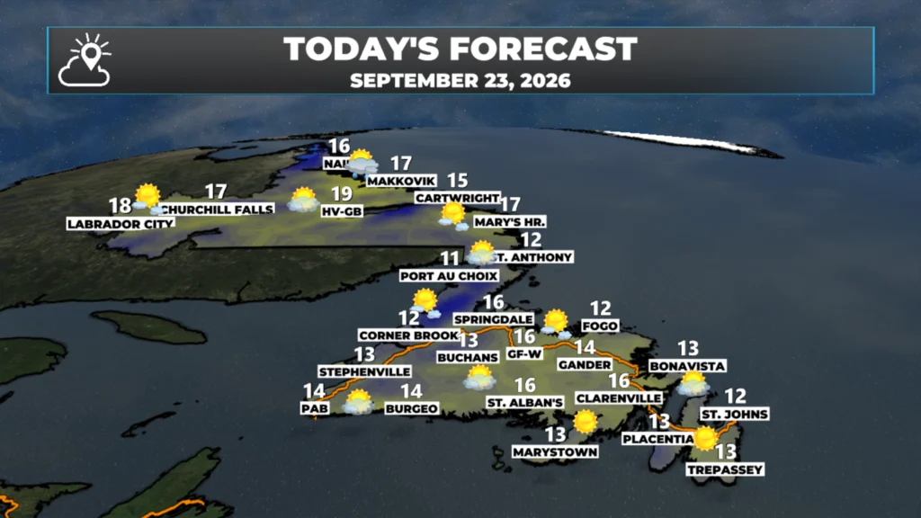
Expect sunshine and highs in the teens to near 20ºC this afternoon.
High pressure builds in and brings a prolonged stretch of quiet weather with it.
This morning’s update is sponsored by Roebothan, McKay, Marshall.

Visit MakeTheCall.ca today to learn more about how the law firm can help you!
We are off to a bit of a chilly start across the Province this morning, with temperatures ranging from near freezing to about the middle and upper single digits. The coolest readings are found in parts of central Newfoundland and in Labrador West. Luckily, wind speeds are light, so we don’t have to worry about much of a wind chill as we start the day.


Radar imagery shows a few lingering showers over the Avalon at this early hour, but once those pass south in the next little while, skies across the Avalon will turn sunny, which will be the main trend across the Province today. Sunny skies will be the rule rather than the exception.
For the remainder of the day, expect sunny skies across Newfoundland and Labrador with highs reaching the teens to near 20º this afternoon. Wind speeds will be light to moderate. This is the shortest forecast I’ve written in a long time!
NOR’EASTER TAKES SHAPE SOUTH OF NL LATER THIS WEEK (NO IMPACTS TO NL EXPECTED AT THIS TIME)
A large high will keep the weather across Atlantic Canada dry and sunny for the next several days. South of that high, a Nor’easter will take shape and looks like it will batter parts of the Northeastern United States and Maritime Provinces with rain, wind, and possible storm surge later this week or by the weekend. While this storm will garner plenty of attention due to its proximity to major cities like New York, Boston, and Philly, at this time this system does not pose a threat to our weather. The high-pressure center setting up shop will keep this low well to our south, and that is how it will stay unless there are some major changes to the pattern and subsequent forecasts. I’ll be watching just in case that happens.

I’ll have a fully updated forecast this afternoon; until then, make sure to check out the link below!
📱 Get the Sheerr Weather App in the Apple App Store and Google Play Store.
🗺️ Check out the Map Room to see all the latest weather observations for the Province.
🎥 Check out the Provincial Highway Cams to see 👀 what’s going on around our highways and
Thanks Eddie
Thanks Eddie, have a great day and stay safe
Thank you, Eddie, for keeping us updated. Great work!
Always there for all of us! And….so are we for you!
Thanks Eddie…I love these fall mornings. Have a great day.
Thanks Eddie
Have a Great Day ‼️
Eddie you are the best! Thank you for all the info each day.
Good morning Eddie,thanks for weather update.
Good morning Eddie!Thanks for the update….
Good morning Eddie, thanks for the update . Have a great day.
Good m
Good morning Eddie, thanks for the update. Looking forward to the nice weather! Have a great day 😊
Good morning from New Brunswick Eddie, it’s a sunny day here, great weather here for our little road trip from NL, have a wonderful day