Good Tuesday morning! Here are today’s weather highlights:
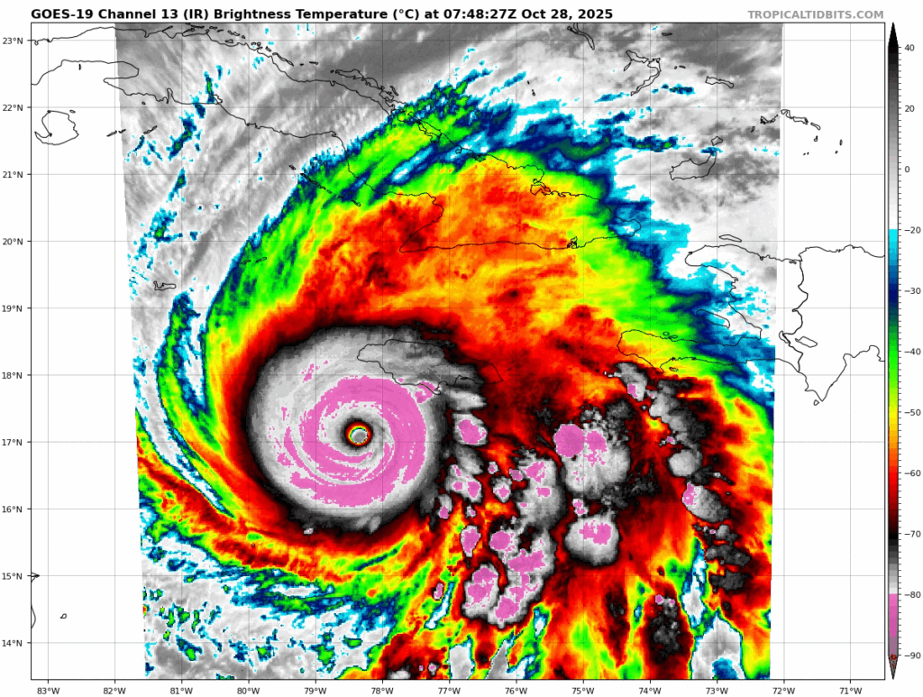
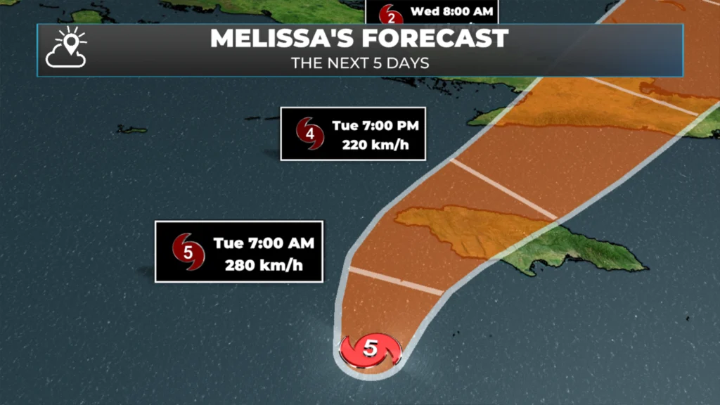
Hurricane Melissa is south of Jamaica this morning and is slowly moving northward. The Category 5 storm will increase its speed today, and the core will cross over the island nation. The question isn’t whether there will be damage, destruction, and devastation but where and how severe it will be.
An area of low pressure spinning south of Newfoundland and and an area of high pressure over Quebec will combine to bring a dry day to most of NL.
There will be some pockets of drizzle and fog along and near east and northeast facing shores of eastern Newfoundland today in onshore flow.
Expect sunshine in most of Labrador today, and decreasing amounts of cloud on the Island from west to east this afternoon.
This morning’s update is sponsored by Roebothan, McKay, Marshall.
Sponsored
Visit MakeTheCall.ca today to find out what the law firm can do for you!
Hurricane Melissa continues to spin south of Jamaica this morning and is crawling northward. As of 3:30 AM NDT, the strom was located 215 kilometres southwest of Kingston, Jamaica. The maximum sustained winds were an astonishing 280 km/h with higher gusts. Hurricane-force winds extend 45 km out from the centre. The movement is toward the north northeast at 4 km/h and the central pressure is 901 mb.
Melissa bearing down on Jamaica this morning with recon data that continues to support the rarest group of hurricanes to ever roam the atlantic in our lifetime. There have only been 6 hurricanes with sub 900mb pressures in the basin. Melissa could join them before landfall.… pic.twitter.com/Mkjt8KjUAV
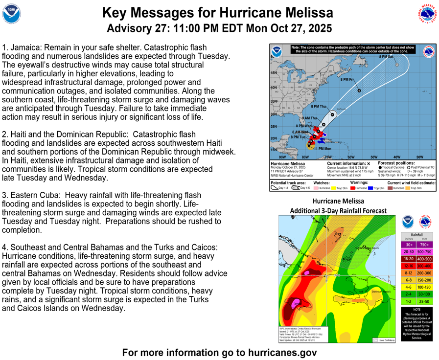
The storm will accelerate in forward speed today, and the core will pass over the Island of Jamaica. Catastrophic flash flooding and numerous landslides are expected through Tuesday. The eyewall’s destructive winds will cause total structural failure, particularly in higher elevations where wind speeds may be as much as 30% higher. Widespread infrastructure damage, prolonged power and communication outages, and communities becoming isolated will occur. Along the southern coast, a storm surge of nearly 4 meters will be life-threatening when combined with damaging waves. The National Hurricane Center in the US states that failure to take immediate action to find a safe place may result in serious injury or loss of life.
Once the storm crosses Jamaica, it will move north and affect Cuba, southwestern Haiti, and the southern portions of the Dominican Republic. Catastrophic flash flooding and landslides are expected across parts of those areas through midweek. Rainfall through much of the region, including Jamaica, will be 300 to 750+ mm.
Across our region today, the weather will be less severe. An area of low pressure south of Newfoundland and a high pressure system over Quebec will combine to bring onshore flow to eastern and northeast Newfoundland. The high pressure center will keep the low to the south, meaning any precipitation from it should stay offshore. Because of the onshore flow, some locations from the Avalon to Bonavista Bay will experience pockets of fog and drizzle today.
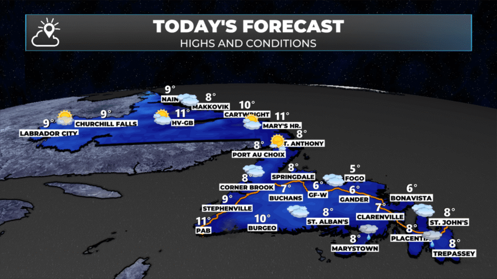
We can expect sunshine over the Big Land today and the western third of the Island. Farther east, it will be generally cloudy this morning, with decreasing clouds throughout the day. In the east, the clouds will linger today but will clear overnight. I expect more widespread sunshine tomorrow. Highs will be in the 7ºC to 10ºC range today.
The animation below shows the cloud cover moving out from west to east throughout the day. This will lead to a dry Wednesday, Thursday, and Friday. After that, it looks like we might see some significant rainfall from an area of low pressure spinning through Labrador and possibly the remnants of Hurricane Melissa. Stay tuned for updates on this.
⚠ Storm ModeGet warnings pushed to your phone the moment they’re issued.Get the app
By using this website, you agree to our use of cookies. We use cookies to provide you with a great experience and to help our website run effectively. Privacy Policy



Good morning, thanks for the update
Good Morning Eddie! Not a bad forecast for Newfoundland. Thinking of the people of Jamaica today
Good morning Eddie, thanks for weather update.
Thinking and praying for all the people in the path of this monstrous hurricane!! 🙏🏻🙏🏻