
Coastal Flooding and Storm Surge Risks for Newfoundland this week
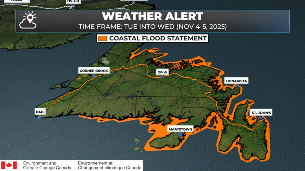
Coastal Flood Statements are in effect for much of Newfoundland’s coastline | November 3, 2025
Environment Canada has issued multiple statements warning of higher than normal water levels, large waves, and potential coastal flooding for parts of Newfoundland between Tuesday and Friday as a powerful low-pressure system tracks across the region.
South Coast (Ramea to the Burin Peninsula)
Regions affected: West of Ramea to the Burin Peninsula
What’s expected
Moderate storm surge and large waves will impact the south-facing shorelines from west of Ramea to the Burin Peninsula.
Maximum wave heights: 4 to 6 metres, breaking on approach to shore
Timing
Tuesday afternoon and evening
Greatest impact near high tide (6 p.m. – 8 p.m.)
Potential impacts
Pounding surf and elevated water levels may lead to localized flooding and coastal erosion
Infrastructure along vulnerable coastlines could be at risk, especially where similar past events have caused damage
Southern Avalon Peninsula
Regions affected:
Southern coastline of the Avalon Peninsula
Eastern and northern shorelines of Placentia Bay, including the Ragged Islands
What’s expected
Higher than normal water levels and large waves are expected along the southern Avalon, especially on south-facing shorelines.
Maximum wave heights: 6 to 9 metres, breaking near shore
Timing
Tuesday afternoon through Wednesday morning
Most significant impacts near high tide
High Tides:
First: 6 p.m. – 8 p.m. Tuesday
Second: 6 a.m. – 8 a.m. Wednesday
Potential impacts
Large waves and pounding surf could cause coastal erosion and damage to shoreline infrastructure
Areas historically prone to surge and wave impacts may experience renewed coastal effects
East and Northeast Coasts Including Northern Avalon
Regions affected:
White Bay – Baie Verte – La Scie | Green Bay | Bay of Exploits | Gander Bay to Lumsden | Bonavista Bay (north, west, south shores) | Trinity Bay (all shores) | Conception Bay (all shores including Bell Island) | Eastern Avalon coastline
What’s expected
High storm surge and large waves will combine with higher than normal water levels along north-facing shorelines of the northeast and east coasts.
Maximum wave heights: 4 to 6 metres
Timing
Wednesday afternoon through Friday morning
Highest risk coincides with high tide
High Tide Times:
• First: 6 p.m. – 8 p.m. Wednesday
• 2nd: 6 a.m. – 8 a.m. Thursday
• 3rd: 6 p.m. – 8 p.m. Thursday
• 4th: 6 a.m. – 8 a.m. Friday
Potential impacts
Coastal flooding possible in low-lying and exposed areas
Wave action and storm surge may cause erosion and shoreline damage, particularly where exposure to open water is greatest
⚠️ Stay Informed
Environment Canada advises coastal residents and mariners to monitor forecasts, warnings, and tide times closely. Sheerr Weather will provide updates as the system intensifies through Tuesday and Wednesday, with onshore winds and wave action peaking near high tide.
How bad in Fox Harbour area
Excellent Eddie. Tks
Thanks for the update
Thanks so much Eddie for the updates. We appreciate it. Everyone stay safe.
Nothing for us on the Westcoast?
Thanks Eddie for weather update
Thank you Eddie for the very informative weather update!
Have a great day!…Stay safe!
Thanks. We are preparing now. Generator all ready in the event of power outage. 😊
Always prepared thanks to Eddie… he has saved countless lives over the years with his accurate weather reporting
Thank You for our much appreciated detailed weather forecast. Stay safe everyone!!
Thanks Eddie!!!!
Thanks Eddie