
Historic November Storm Sets New Pressure Records Across Newfoundland and Labrador
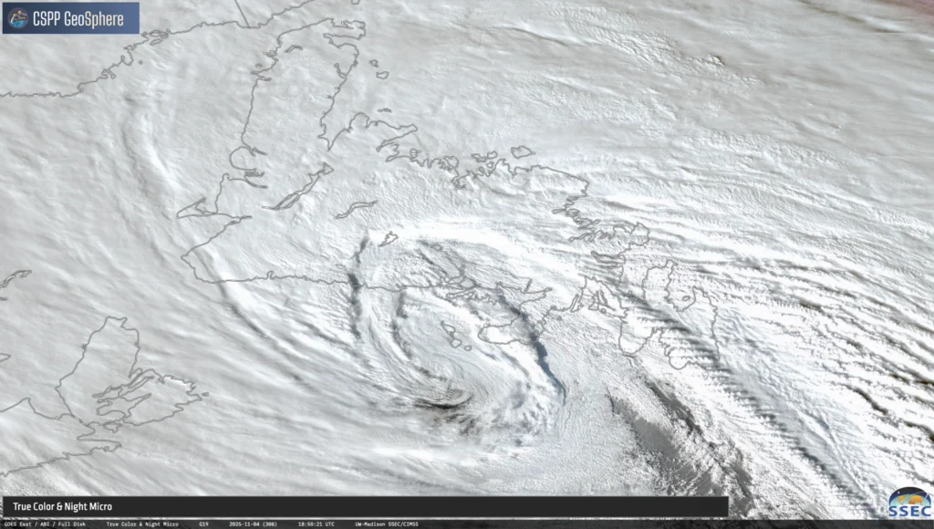
A snapshot of Tuesday’s low as it approached the Burin Peninsula. Image take at 3:20 PM NST
An intense storm system that formed off Cape Hatteras on Monday brought historic weather to Newfoundland and Labrador. The low-pressure system rapidly intensified as it tracked south of Nova Scotia and into Placentia Bay on Tuesday (November 4, 2025), undergoing what meteorologists call explosive cyclogenesis—or “bombogenesis.”
To meet the criteria for bombogenesis, a storm’s central pressure must fall by at least 24 millibars within 24 hours. This system far exceeded that threshold, dropping 60 millibars in just one day—a rate 2.5 times stronger than required.
Record-Breaking Pressure Readings
The storm set preliminary new records for the lowest mean sea level pressure (MSLP) ever recorded in November across the province.
Marticot Island recorded a pressure of 944.7 mb, the lowest November value on record for Newfoundland and Labrador. This breaks the previous record of 950.7 mb measured in Nain on November 7, 1987 (records since 1984).
St. John’s International Airport dropped to 950.5 mb, shattering its previous November record of 963.1 mb from November 30, 2019 (records since 1959).
Widespread Wind and Coastal Impacts
Winds reached hurricane-force in many coastal areas, leading to widespread damage and flooding. Massive waves washed over roadways, scattered debris, and flooded low-lying coastal infrastructure. Thousands across the Island experienced power and communication outages as the storm moved through Tuesday night.
Top wind gusts (km/h):
Cape St. Mary’s: 172*
Trepassey (Powles Head): 171*
Cape Race: 162^
Cape Pine: 156*
Sagona Island: 155
Musgrave Harbour: 136*
Calvert: 135*
Fort Point (Trinity Bay): 119*
Twillingate: 119
Lamaline: 116*
St. John’s Int’l Airport: 109
(* = unofficial reporting station; ^ = data under review)
Several weather stations stopped reporting late Tuesday, likely due to power or communication failures, meaning some peak wind data may still be missing.
Rain and Snowfall Totals
While wind and storm surge caused the most severe impacts, precipitation totals were more modest. Rain dominated eastern Newfoundland, while central and western regions saw a mix of rain and wet snow.
Rainfall (mm):
Burin Bay Arm: 57.0*
Lamaline: 54.5*
Winterland (Branch Hill): 51.4
St. Lawrence: 44.3
(* = unofficial reporting station)
Snow-on-ground sensors indicated 2 to 7 cm of wet snow accumulation across central and western areas. Slippery roads and reduced visibility led to difficult driving conditions through Tuesday evening.
A Storm for the Record Books
Environment and Climate Change Canada notes that these figures are preliminary and may be updated after data verification. Still, with pressures never before recorded in November and wind gusts topping 170 km/h, this event will likely go down as one of Newfoundland and Labrador’s most powerful November storms on record.
Thanks Eddie for the update, it was definitely a windy one
Wow!!!
Thanks, Eddie, for all your weather reporting.
This just may be a precursor to what we will have in store for the coming years. Storms are becoming stronger and more frequent. Hold on to your hats, it’s just the beginning.
Thanks Eddie for afternoon weather update.
Thanks Eddie , for keeping us so informed
Thank you
Thanks Eddie for all ur updates 👍🏻 it was a rocking night for sure 🤦♀️