
Wednesday Morning Weather Brief — November 12, 2025
Good Wednesday morning!
The latest radar loop shows the rain has finally ended on the eastern side of the Island. Western areas are still experiencing rain and showers in response to a developing area of low pressure tracking into the Lower North Shore of Quebec and southern Labrador at this hour.

This update is sponsored by Roebothan, McKay, Marshall. Accident and Injury Law.
Rainfall amounts over the last 24 hours have been significant, and a few areas in southern Newfoundland are reporting totals near or exceeding 100 mm. Here is a list of some totals. Note that not all areas have rain gauges, and subsequently, there are more places where I don’t know how much rain fell than where I do.
St. Albans – 94.3 mm
St. Lawrence – 93.5 mm
Winterland – 78.4 mm
Burgeo – 72.2 mm
PAB – 66.3 mm
St. John’s West – 50.2 mm
Millertown – 47.4 mm
Argentia – 45.6 mm
Terra Nova – 42.1 mm
Badger – 39.1 mm
Wreckhouse – 37.6 mm
La Scie – 37.6 mm
St. John’s YYT – 36.6 mm
Ferolle Point – 34.8 mm
Cormack – 33.4 mm
Cape Race – 33.0 mm
Stephenville – 32.2 mm
Hopedale – 32.0 mm
Mary’s Harbour – 31.3 mm
HV-GB – 21.8 mm
Nain – 23.6 mm
Deer Lake – 27.7 mm
Bonavista – 21.5 mm
Rocky Harbour – 15.7 mm
St. Anthony – 14.6 mm
I have seen reports on Facebook of localized flooding in parts of the Burin Peninsula. I know there was some minor flooding in the area around St. Lawrence. There are reports of more significant flooding in the Baine Harbouor area. As more information on that becomes available, I will be sure to post updates.
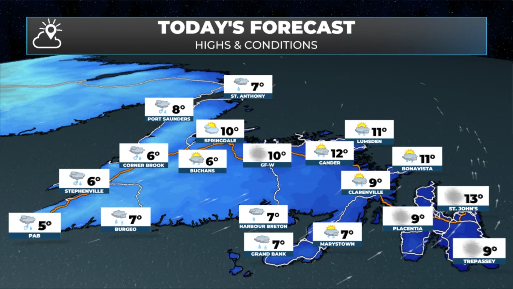
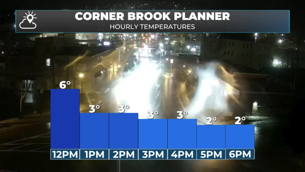
The rain on the Island is pretty well done for today, outside of the West Coast. On and near the West Coast, the rain showers will end this morning, but onshore rain and snow showers will develop through the day as colder air moves in. Speaking of cool air, it’s quite mild in many areas, but temperatures will either remain steady or drop through the afternoon.
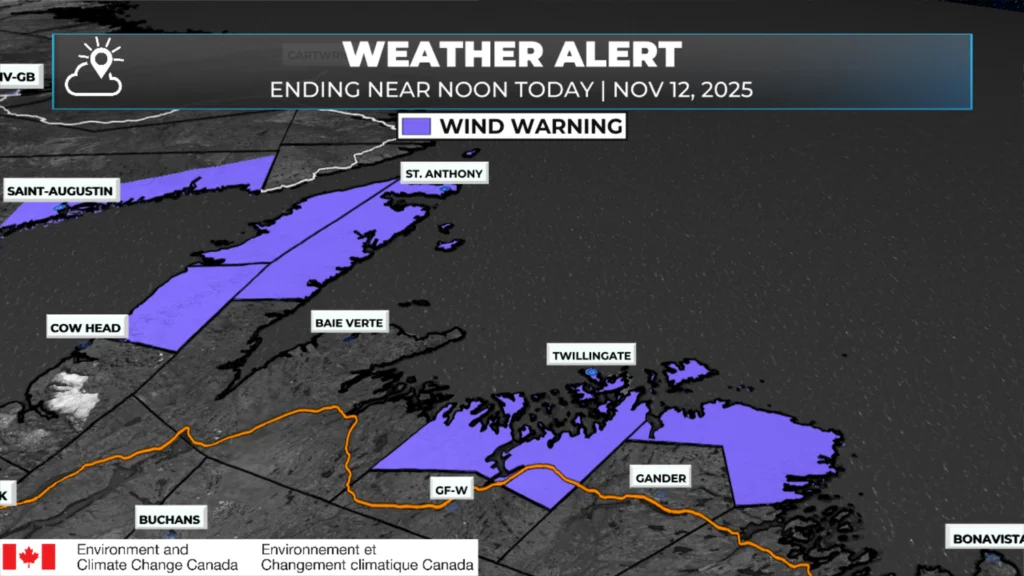
Wind Warnings remain in effect for parts of Central and northern Newfoundland this morning for gusts as high as 100 km/h. Those are slated to be ended by noon as wind speeds decrease throughout the day.
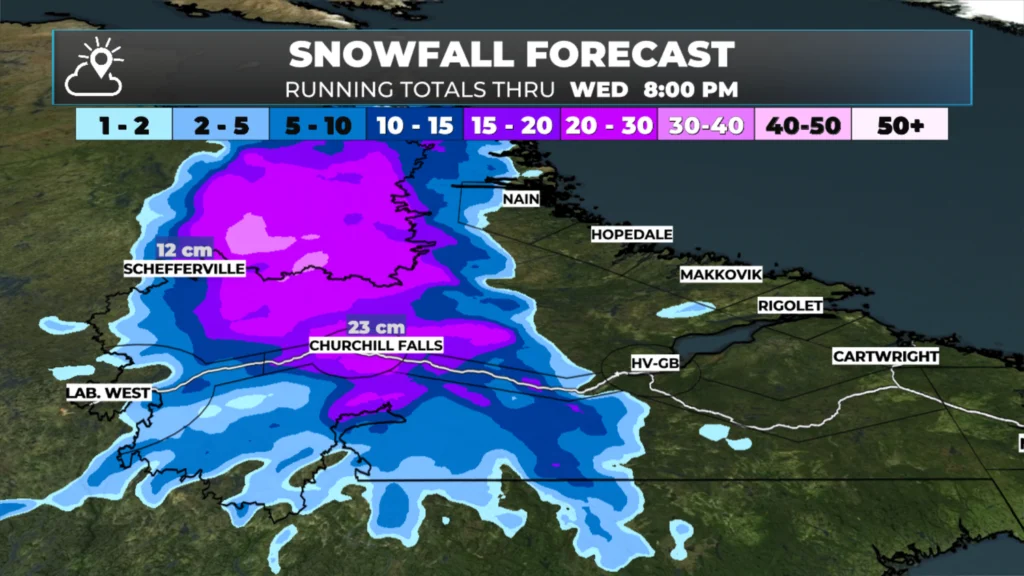
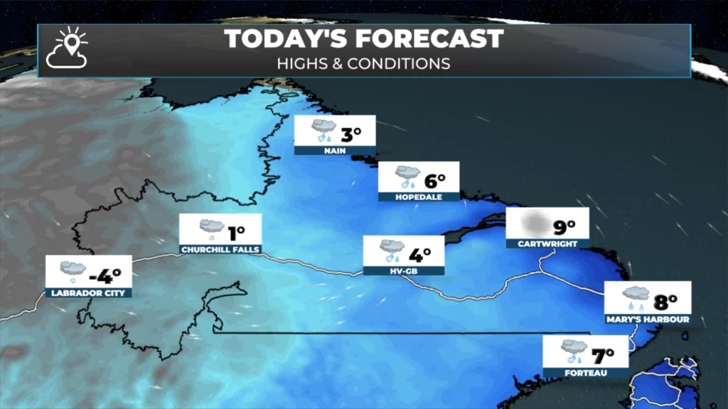
While the weather improves on the Island and in some of Labrador, the central part of the Big Land will not be so lucky. An area of low pressure will bring more significant snowfall to the Churchill Valley and Churchill Falls through today. A Snowfall Warning remains in effect for these areas and will be in effect through the remainder of the day or this evening.
The area of low pressure bringing the snow to central Labrador will keep the rain and wind ongoing along much of the coast today. As that moves north of the area by evening, the weather in the Big Land will improve overnight, and Thursday should be much calmer. I do think flights to the coast will resume Thursday and for some of Friday before the next weather-maker rolls in.
The weather is unlikely to remain calm for long, as another low will bring more rain and possibly snow to Newfoundland and Labrador tomorrow and Friday. I’ll have an update on this later today.
📱 Get the Sheerr Weather App in the Apple App Store and Google Play Store.
🗺️ Check out the Map Room to see all the latest weather observations for the Province.
🎥 Check out the Provincial Highway Cams to see 👀 what’s going on around our highways and byways!
What’s the weather from Fox Harbour to St John’s on Thursday